
Groundwater/Surface-Water Interactions
Groundwater/Surface-Water Interactions
Filter Total Items: 6
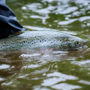
Thermal Imaging to Detect Cold-Water Habitat for Atlantic Salmon and Brook Trout at Katahdin Woods and Waters National Monument
The U.S. Geological Survey (USGS), in cooperation with the National Park Service (NPS), is using airborne thermal infrared remote sensing to characterize cold-water habitat for the federally designated endangered species Atlantic salmon ( Salmo salar) and wild brook trout ( Salvelinus fontinalis) in the East Branch of the Penobscot River system within Katahdin Woods and Waters National Monument...

Regional Regression Equations for Estimating Selected Low-flow Statistics at Ungaged Stream Sites in Massachusetts
The U.S. Geological Survey, in cooperation with the Massachusetts Department of Recreation and Conservation, Office of Water Resources, began a study in 2019 to update the regional regression equations for estimating selected low-flow statistics at ungaged sites in Massachusetts.

Effects of Sea-Level Rise and Climate Change on the Groundwater-Flow System of Martha’s Vineyard, Massachusetts
The U.S. Geological Survey (USGS), in cooperation with the Massachusetts Department of Environmental Protection (MassDEP), is investigating the effects of sea-level rise and climate change on the groundwater resources of Martha’s Vineyard, Massachusetts.

Hydrologic Monitoring in the Three Bays Watershed in Support of Nutrient Management Activities, Cape Cod, Massachusetts
In 2019 the USGS began a partnership with the U.S. Environmental Protection Agency (EPA) Office of Research and Development (ORD), EPA Region 1 Southeast New England Program for Coastal Watershed Restoration (SNEP), Barnstable Clean Water Coalition (BCWC), and other stakeholders to conduct hydrologic monitoring and assessment in support of multifaceted nutrient-management activities in the Three...

Assessment of Hydrologic and Water-Quality Changes in Shallow Groundwater Beneath a Coastal Neighborhood Being Converted from Septic Systems to Municipal Sewers
The U.S. Geological Survey and the U.S. Environmental Protection Agency are collaborating on a study to better understand changes to groundwater quality beneath a densely developed coastal neighborhood as it undergoes conversion from onsite wastewater disposal to municipal sewering.

Groundwater and Surface-Water Monitoring in the Mill Creek Watershed, Wellfleet and Truro, Massachusetts
The Herring River estuary and salt marsh system, within the Cape Cod National Seashore in Wellfleet, Massachusetts, has been diked off from the ocean for more than 100 years. The National Park Service is now preparing to restore the 1,100 acre estuary-marsh system.