
USGS Technician Kaitlin Zoida, using an EXO2 water quality probe to sample the Cedar Creek
Images
Images intro.
Filter Total Items: 269

Good day to sample
USGS Technician Kaitlin Zoida, using an EXO2 water quality probe to sample the Cedar Creek
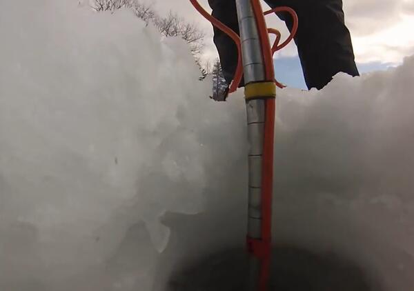
Ice Flow Sampling
USGS Scientist lowering a current meter into an Ice Bore Hole from the USGS "Under The Ice" video linked
USGS Scientist lowering a current meter into an Ice Bore Hole from the USGS "Under The Ice" video linked

Weir on the rahway
Standard design broad crested weir control for streamgage on the Rahway River in NJ.
Standard design broad crested weir control for streamgage on the Rahway River in NJ.

Hydrogeology controls contaminant transport in fractured rock
Hydrogeology controls contaminant transport in fractured rockCross section shows interpreted paths of contaminant transport during a field experiment to quantify transport and reaction rates of TCE and other contaminants in fractured sedimentary rock at the former Naval Air Warfare Center, West Trenton, N.J.

Weir on the Saddle River
Close up of gradually sloping broad crested weir providing stable control for streamgage along the Saddle River in NJ.
Close up of gradually sloping broad crested weir providing stable control for streamgage along the Saddle River in NJ.

Barnegat Light from across the Bay
View of Barnegat Light from the side of a USGS boat looking past the GPS on a recording mast.
View of Barnegat Light from the side of a USGS boat looking past the GPS on a recording mast.

Swabbing Wood Frog Tadpoles
Scientist swabbing a wood frog tadpole for the fungal pathogen, Batrachochytrium dendrobatidis (Bd)
Scientist swabbing a wood frog tadpole for the fungal pathogen, Batrachochytrium dendrobatidis (Bd)

Installation of a basestation
USGS Geologist Francis Ashland and USGS Hydrologist Alex Fiore installing a base station at the OBB monitoring site
USGS Geologist Francis Ashland and USGS Hydrologist Alex Fiore installing a base station at the OBB monitoring site

Sediment Sample seperation
Scientist screening and seprating sediment sample for storage during a Post-Sandy sampling trip.
Scientist screening and seprating sediment sample for storage during a Post-Sandy sampling trip.

Sampling Sediment
Scientist retrieving sedimant from a ponar during Post-Sandy sampling
Scientist retrieving sedimant from a ponar during Post-Sandy sampling

01409110.3.JPG
USGS New Jersey WSC Tide Network Site 01409110, Barnegat Bay at Waretown as found following Hurricane Sandy.
USGS New Jersey WSC Tide Network Site 01409110, Barnegat Bay at Waretown as found following Hurricane Sandy.
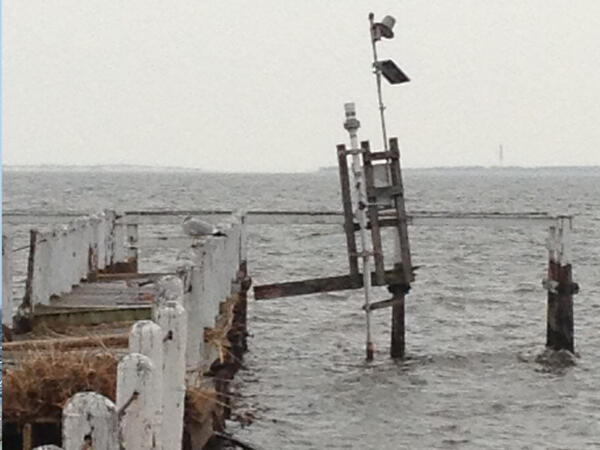
Waretown post-Sandy
Closer view of USGS New Jersey WSC Tide Network site 01409110, Barnegat Bay at Waretown as found following Hurricane Sandy.
Closer view of USGS New Jersey WSC Tide Network site 01409110, Barnegat Bay at Waretown as found following Hurricane Sandy.

Flooded House in Mantoloking
Flooded house in the aftermath of Hurricane Sandy in Mantoloking, New Jersey
Flooded house in the aftermath of Hurricane Sandy in Mantoloking, New Jersey

Hurricane Sandy flood effects 2012, Seaside Heights NJ
Hurricane Sandy flood effects 2012, Seaside Heights NJHurricane Sandy struck the New Jersey shore Oct. 29-31, 2012. Houses, cars and a street in Seaside Heights, NJ were covered in beach sand after Hurricane Sandy's storm tide receded.
Hurricane Sandy flood effects 2012, Seaside Heights NJ
Hurricane Sandy flood effects 2012, Seaside Heights NJHurricane Sandy struck the New Jersey shore Oct. 29-31, 2012. Houses, cars and a street in Seaside Heights, NJ were covered in beach sand after Hurricane Sandy's storm tide receded.

Hurricane Sandy flood effects 2012, Mantoloking, NJ
Hurricane Sandy flood effects 2012, Mantoloking, NJHurricane Sandy struck the New Jersey shore Oct. 29-31, 2012. This house in Mantoloking, NJ was partly collapsed after Hurricane Sandy's storm tide receded.
Hurricane Sandy flood effects 2012, Mantoloking, NJ
Hurricane Sandy flood effects 2012, Mantoloking, NJHurricane Sandy struck the New Jersey shore Oct. 29-31, 2012. This house in Mantoloking, NJ was partly collapsed after Hurricane Sandy's storm tide receded.

Hurricane Sandy flood effects 2012, Seaside Heights, NJ
Hurricane Sandy flood effects 2012, Seaside Heights, NJHurricane Sandy struck the New Jersey shore Oct. 29-31, 2012. This house in Seaside Heights, NJ lost part of its foundation, leaving a front porch suspended in mid-air.
Hurricane Sandy flood effects 2012, Seaside Heights, NJ
Hurricane Sandy flood effects 2012, Seaside Heights, NJHurricane Sandy struck the New Jersey shore Oct. 29-31, 2012. This house in Seaside Heights, NJ lost part of its foundation, leaving a front porch suspended in mid-air.

Checking Tide Sensors
New Jersey Ambar docked at tide sensor on a bridge footer at East Thorofare at Ship Bottom, NJ (01409146).
New Jersey Ambar docked at tide sensor on a bridge footer at East Thorofare at Ship Bottom, NJ (01409146).

Blossoming Cherry in New Jersey
The back walk-up to the New Jersey Water Science Center with a bright pink chery tree in blossom.
The back walk-up to the New Jersey Water Science Center with a bright pink chery tree in blossom.
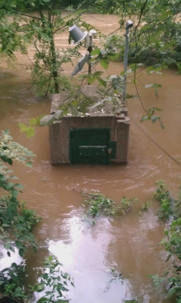
Flooded Gage
Flooding at the streamgaging station on the Saddle River at Lodi, NJ (U.S.Geological Survey station 01391500), after the peak on August 28, 2011.
Flooding at the streamgaging station on the Saddle River at Lodi, NJ (U.S.Geological Survey station 01391500), after the peak on August 28, 2011.
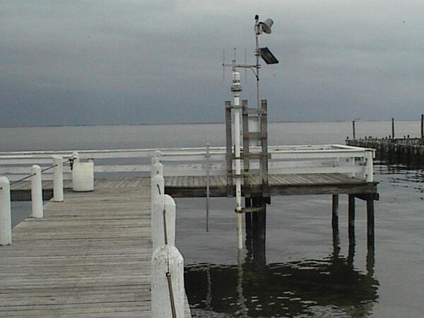
Waretown pre-Sandy
The USGS 01409110 Barnegat Bay near Waretown, New Jersey tide station before Hurricane Sandy destroyed it.
The USGS 01409110 Barnegat Bay near Waretown, New Jersey tide station before Hurricane Sandy destroyed it.

Atsion Lake
Mist on surface of Atsion Lake as seen from the spillway in Atsion, New Jersey
Mist on surface of Atsion Lake as seen from the spillway in Atsion, New Jersey