
Pamela Reilly, Hydrologist
Images
Images intro.
Filter Total Items: 280

Pam Reilly
Pamela Reilly, Hydrologist

Del_Riv_at_Montique
Looking upstream at the Delaware River at Montique (01438500) USGS gage house tower.
Looking upstream at the Delaware River at Montique (01438500) USGS gage house tower.

Data Collection Platform
Data Collection Platform (DCP) setup at a private well monitoring site.
Data Collection Platform (DCP) setup at a private well monitoring site.

Dragonfly on tagline
Northeast Region Photo Contest Winner | Sept 2019 | Honorable Mention
Dragonfly on tagline
Northeast Region Photo Contest Winner | Sept 2019 | Honorable Mention
Dragonfly on tagline

Hopatcong Buoy
USGS scientists deploy a monitoring buoy on Lake Hopatcong, New Jersey, to monitor water-quality conditions and a harmful algal bloom in near real-time. USGS scientist Karl Braun is photographed.
USGS scientists deploy a monitoring buoy on Lake Hopatcong, New Jersey, to monitor water-quality conditions and a harmful algal bloom in near real-time. USGS scientist Karl Braun is photographed.

Sampling Hopatcong
USGS scientists Brad Bjorklund and Jon Cohl collect a water-quality sample at Lake Hopatcong, New Jersey, to monitor a harmful algal bloom on the lake.
USGS scientists Brad Bjorklund and Jon Cohl collect a water-quality sample at Lake Hopatcong, New Jersey, to monitor a harmful algal bloom on the lake.

Hopatcong Warning
The New Jersey Department of Environmental Protection advised the public to avoid swimming in or contact with Lake Hopatcong water due to a harmful algal bloom confirmed in June 2019 by aerial surveillance. To help study water-quality conditions and the bloom’s severity, the USGS installed a monitoring buoy on the lake in July.
The New Jersey Department of Environmental Protection advised the public to avoid swimming in or contact with Lake Hopatcong water due to a harmful algal bloom confirmed in June 2019 by aerial surveillance. To help study water-quality conditions and the bloom’s severity, the USGS installed a monitoring buoy on the lake in July.

Hopatcong Monitor
USGS scientists Lisa Carper and Jon Cohl deploy a monitoring buoy at Lake Hopatcong, New Jersey, to monitor water-quality conditions and a harmful algal bloom in near real-time.
USGS scientists Lisa Carper and Jon Cohl deploy a monitoring buoy at Lake Hopatcong, New Jersey, to monitor water-quality conditions and a harmful algal bloom in near real-time.

Algal Bloom on Hopatcong
Harmful Algal Bloom on Lake Hopatcong.
Harmful Algal Bloom on Lake Hopatcong.

Decontamination
Hydrographer Jonathan Cohl sprays down the boat and trailer, used to deploy a Harmful Algal Bloom (HAB) water quality monitoring buoy on Lake Hopatcong, with a decontamination solution. This is a very important step between missions when vessels are used in multiple bodies of water.
Hydrographer Jonathan Cohl sprays down the boat and trailer, used to deploy a Harmful Algal Bloom (HAB) water quality monitoring buoy on Lake Hopatcong, with a decontamination solution. This is a very important step between missions when vessels are used in multiple bodies of water.

Monitor Buoy
USGS monitoring buoy deployed on Lake Hopatcong, New Jersey, to monitor water-quality conditions and a harmful algal bloom in near real-time.
USGS monitoring buoy deployed on Lake Hopatcong, New Jersey, to monitor water-quality conditions and a harmful algal bloom in near real-time.

Waretown2019
USGS New Jersey WSC Tide Network Station 014090110, Barnegat Bay at Waretown, after Storm Hardening upgrades following Hurricane Sandy
USGS New Jersey WSC Tide Network Station 014090110, Barnegat Bay at Waretown, after Storm Hardening upgrades following Hurricane Sandy
Acoustic Tide Gage
The sensor and vent head of an acoustic type tide gage at USGS 01409125 Barnegat Bay at Barnegat Light, New Jersey.
The sensor and vent head of an acoustic type tide gage at USGS 01409125 Barnegat Bay at Barnegat Light, New Jersey.
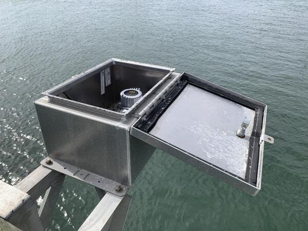
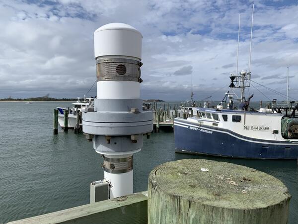
Radar Tide Gage
Looking into the housing box of a radar tide gage deployed at the USGS 01409125 Barnegat Bay at Barnegat Light, New Jersey, tide station.
Looking into the housing box of a radar tide gage deployed at the USGS 01409125 Barnegat Bay at Barnegat Light, New Jersey, tide station.

Delaware River at Lambertville, NJ and New Hope, PA
Delaware River at Lambertville, NJ and New Hope, PAPhoto of the Deleware River near Lambertville, NJ and New Hope, PA.
Delaware River at Lambertville, NJ and New Hope, PA
Delaware River at Lambertville, NJ and New Hope, PAPhoto of the Deleware River near Lambertville, NJ and New Hope, PA.

NAWQA Sampling
USGS Scientists collecting Biological samples in stream bed
USGS Scientists collecting Biological samples in stream bed

DeadForest4
Sun setting behind a dead forest and scrubland in the Sandy Hook National Recreation Area Study Area
Sun setting behind a dead forest and scrubland in the Sandy Hook National Recreation Area Study Area

DeadForest3
Sandy roadway through a dead forest in the Sandy Hook National Recreation Area Study Area
Sandy roadway through a dead forest in the Sandy Hook National Recreation Area Study Area

Recording Groundwater Levels
USGS Hydrologist Robert Rosman sketching site information at a production well during a water-level-site visit, Camden County.
USGS Hydrologist Robert Rosman sketching site information at a production well during a water-level-site visit, Camden County.

Worthington groundwater tapedown
USGS Hydrologist Robert Rosman using an electric tape to measure static water level in a production well, Burlington County.
USGS Hydrologist Robert Rosman using an electric tape to measure static water level in a production well, Burlington County.

Layne Tapedown
USGS Scientist Robert Rossman checking groundwater levels with a steel tape
USGS Scientist Robert Rossman checking groundwater levels with a steel tape