
Hydrologic Modeling
Hydrologic Modeling
Numerical and statistical models provide tools to integrate our understanding of hydrologic processes with field data at a range of spatial and temporal scales to assess and evaluate the effects of human activities on hydrologic systems.
Filter Total Items: 10

Water Levels in the Ten Major Confined Aquifers of the New Jersey Coastal Plain
The Coastal Plain aquifers of New Jersey provide an important source of water for more than 3.5 million people. The USGS, in cooperation with the New Jersey Department of Environmental Protection, has been measuring water levels in the confined aquifers of the New Jersey Coastal Plain every five years beginning in 1978. Persistent, regionally extensive cones of depression are present in Ocean and...
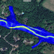
Flooded Roadway and Bridge Crossing Mapping and Early Warning System for Selected Communities in Hunterdon County, New Jersey
This project seeks to develop methods to identify when a flooded roadway or bridge crossing condition may exist and to provide a tool for users to select rainfall scenarios in addition to the selected river condition to estimate if road flooding may occur with the selected combination. These tools will provide officials in Hunterdon County and at the state level of management better early warning...

New Jersey: Coastal Flood Inundation Mapping
The U.S. Geological Survey (USGS) in cooperation with the New Jersey Department of Environmental Protection and New Jersey Office of Emergency Management conducted a study to produce flood-inundation maps for storm surge flooding scenarios in the coastal areas of 10 New Jersey counties. The coastal storm-surge inundation maps were created from data modelled in the FEMA Region II Coastal Storm...

Program to Maintain and Update Groundwater Models
The Model Maintenance program, in cooperation with the N.J. Department of Environmental Protection (NJDEP), archives, maintains, updates, and shares groundwater-flow models that have been developed by the New Jersey Water Science Center (NJWSC). The program was started in 1995 to maintain existing groundwater flow models, use standardized procedures to archive the models, update models with recent...

Investigations and Technical Assistance to the Joint Base McGuire-Dix-Lakehurst, New Jersey, in Assessing the Distribution and Transport of Perfluorinated Compounds in Groundwater and Surface Water
The USGS New Jersey Water Science Center provides hydrologic technical assistance to the U.S. Air Force Civil Engineer Center at Joint Base McGuire-Dix-Lakehurst (JBMDL) in New Jersey, regarding contamination issues associated with perfluoroalkyl substances (PFAS), such as perfluorooctanesulfonic acid (PFOS) and perfluorooctanoic acid (PFOA), in groundwater and surface water.

Barnegat Bay Restoration Science
The U.S. Geological Survey (USGS), in cooperation with the New Jersey Department of Environmental Protection (NJDEP) and other partners, is conducting an extensive, coordinated study of physical, chemical, and biological processes in the Barnegat Bay-Little Egg Harbor estuary. The study integrates findings of teams from the USGS New Jersey Water Science Center and USGS Coastal and Marine Science...

Current Period Statistics
The Current Period Streamflow Statistics project is computing low flow statistics for both a historic (1950-1979) and more recent (1990-2019) 30-year period. The computed statistics will provide information about streamflow changes over time and an evaluation of more recent streamflow conditions. The project will also present land-use changes, precipitation patterns, and water use in the...

Research and Investigations
The NJWSC conducts research and investigations related to topics such as groundwater and surface-water quality related to anthropogenic and agricultural activities, hydraulic and hydrologic modeling, tracking the movement of groundwater contamination, groundwater resource assessments and modeling, ecological assessments and response to urbanization, and estimating water-use for human and...

Groundwater Mounding
Simulation of Groundwater Mounding beneath Hypothetical Stormwater Infiltration Basins

Galloway Mathematical Models
The Galloway research team has developed and documented three computer programs for simulating flow and transport in the unsaturated zone that are available to the public. These programs were funded by the Toxics Substances Hydrology Program. The computer codes are written in Fortran F77 and run on a variety of computer systems, including mainframe and personal computers, with only minor...