
W.S. Tyler RX-29-16 ROTAP Machine, USGS - NMWSC
Images
All images in this gallery are considered public domain unless otherwise noted.
Filter Total Items: 102

W.S. Tyler RX-29-16 ROTAP Machine, USGS - NMWSC
W.S. Tyler RX-29-16 ROTAP Machine, USGS - NMWSC

PFAS Surface Water Sampling
Photograph of PFAS sampling at Rio Grande above Buckman Diversion near White Rock, NM, USGS - New Mexico Water Science Center
Photograph of PFAS sampling at Rio Grande above Buckman Diversion near White Rock, NM, USGS - New Mexico Water Science Center

PCB Project Field Photograph, USGS - New Mexico Water Science Center
PCB Project Field Photograph, USGS - New Mexico Water Science CenterField photograph taken for Polychlorinated Biphenyl (PCB) In Albuquerque Stormwater Channels Project, USGS - New Mexico Water Science Center
PCB Project Field Photograph, USGS - New Mexico Water Science Center
PCB Project Field Photograph, USGS - New Mexico Water Science CenterField photograph taken for Polychlorinated Biphenyl (PCB) In Albuquerque Stormwater Channels Project, USGS - New Mexico Water Science Center

Photograph of Zuni Salt Lake, New Mexico
Photograph taken for a USGS project to collect imagery, topographic, and bathymetric data and sources of water and salts of Zuni Salt Lake in west-central New Mexico, 2019.
Photograph taken for a USGS project to collect imagery, topographic, and bathymetric data and sources of water and salts of Zuni Salt Lake in west-central New Mexico, 2019.

Sampling Suspended-sediment Concentration
Tyson Hatch and Fletcher Brinkerhoff sampling suspended-sediment concentration upstream of the Buckman Diversion for the city of Santa Fe on the Rio Grande (08313150 Rio Grande above Buckman Diversion, near White Rock, NM)
Tyson Hatch and Fletcher Brinkerhoff sampling suspended-sediment concentration upstream of the Buckman Diversion for the city of Santa Fe on the Rio Grande (08313150 Rio Grande above Buckman Diversion, near White Rock, NM)
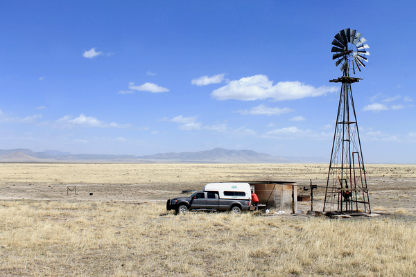
Water quality sampling in the western Plains of San Agustin
Water quality sampling in the western Plains of San AgustinUSGS scientist Mike Carlson works to collect a water quality sample from a windmill in the western Plains of San Agustin. Photo taken by Jeff Pepin on April 10th, 2019.
Water quality sampling in the western Plains of San Agustin
Water quality sampling in the western Plains of San AgustinUSGS scientist Mike Carlson works to collect a water quality sample from a windmill in the western Plains of San Agustin. Photo taken by Jeff Pepin on April 10th, 2019.

Stock tank in the western Plains of San Agustin
USGS scientist Hal Nelson wades in a stock tank to install a fitting on the discharge pipe of a groundwater well to facilitate water quality sampling in the western Plains of San Agustin. Photo taken by Jeff Pepin on April 4th, 2019.
USGS scientist Hal Nelson wades in a stock tank to install a fitting on the discharge pipe of a groundwater well to facilitate water quality sampling in the western Plains of San Agustin. Photo taken by Jeff Pepin on April 4th, 2019.

Gallinas Creek discharge measurement, USGS
Hydrologic Technician Chris Peskuski making a discharge measurement above Gallinas Creek near Montezuma, NM (site data available at: https://waterdata.usgs.gov/nm/nwis/uv?site_no=08380500)
Hydrologic Technician Chris Peskuski making a discharge measurement above Gallinas Creek near Montezuma, NM (site data available at: https://waterdata.usgs.gov/nm/nwis/uv?site_no=08380500)

Stormwater runoff in the Albuquerque urban area, NMWSC
Stormwater runoff in the Albuquerque urban area, NMWSCStormwater runoff in the Albuquerque urban area, NMWSC
Stormwater runoff in the Albuquerque urban area, NMWSC
Stormwater runoff in the Albuquerque urban area, NMWSCStormwater runoff in the Albuquerque urban area, NMWSC
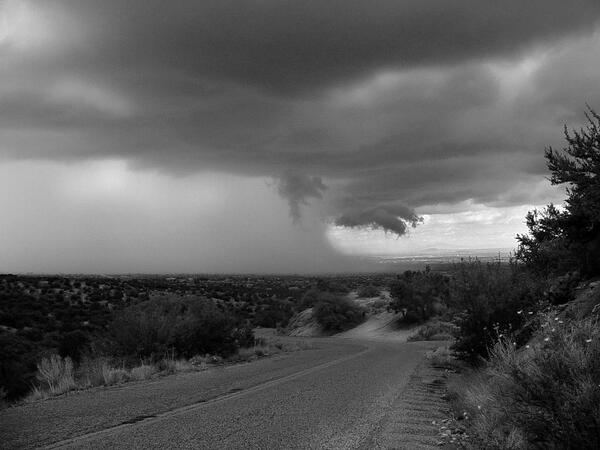
Storm in New Mexico, New Mexico Water Science Center
Storm in New Mexico, New Mexico Water Science CenterThis is a photograph of a storm in New Mexico, USGS - New Mexico Water Science Center
Storm in New Mexico, New Mexico Water Science Center
Storm in New Mexico, New Mexico Water Science CenterThis is a photograph of a storm in New Mexico, USGS - New Mexico Water Science Center

USGS - Roswell Field Office, USGS/BLM
USGS - Roswell Field Office, USGS/BLM
USGS - Roswell Field Office, USGS/BLM

Met Station at Valle de Oro National Wildlife Refuge
Met Station at Valle de Oro National Wildlife RefugeImage of a Met Station at Valle de Oro National Wildlife Refuge, New Mexico, USGS - New Mexico Water Science Center (NMWSC)
Met Station at Valle de Oro National Wildlife Refuge
Met Station at Valle de Oro National Wildlife RefugeImage of a Met Station at Valle de Oro National Wildlife Refuge, New Mexico, USGS - New Mexico Water Science Center (NMWSC)

Rio Grande Gaging Station Sign
Attendees of the 86th Annual Western Snow Conference held in Albuquerque, New Mexico gather at the first streamgaging station established by the United States Geological Survey in 1889 to learn about USGS streamgaging techniques.
Attendees of the 86th Annual Western Snow Conference held in Albuquerque, New Mexico gather at the first streamgaging station established by the United States Geological Survey in 1889 to learn about USGS streamgaging techniques.

Rio Grande at Embudo, NM - First Gaging Station
Staff from the New Mexico Water Science Center pose next to the "First Gaging Station" sign after hosting a technical tour of the site as part of the 86th annual Western Snow Conference.
Staff from the New Mexico Water Science Center pose next to the "First Gaging Station" sign after hosting a technical tour of the site as part of the 86th annual Western Snow Conference.

Sediment Sampling Techniques
Attendees of the 86th Annual Western Snow Conference listen as Tyson Hatch of the New Mexico Water Science Center discusses current and past sediment gaging techniques.
Attendees of the 86th Annual Western Snow Conference listen as Tyson Hatch of the New Mexico Water Science Center discusses current and past sediment gaging techniques.

Discussion on Complexities of the Rio Grande Watershed
Discussion on Complexities of the Rio Grande WatershedStreamside talk about a water managers perspectives on the complexities of the Rio Grande Watershed and the history / need for runoff forecasts for downstream water users.
Discussion on Complexities of the Rio Grande Watershed
Discussion on Complexities of the Rio Grande WatershedStreamside talk about a water managers perspectives on the complexities of the Rio Grande Watershed and the history / need for runoff forecasts for downstream water users.

Jeb Brown Discusses Sediment Sampling Techniques
Attendees of the 86th Annual Western Snow Conference listen as Jeb Brown of the New Mexico Water Science Center discusses current and past sediment gaging techniques.
Attendees of the 86th Annual Western Snow Conference listen as Jeb Brown of the New Mexico Water Science Center discusses current and past sediment gaging techniques.

Digital Elevation Model Created by an Unmanned Aerial System
Digital Elevation Model Created by an Unmanned Aerial SystemThis digital elevation model was created using structure from motion software mounted to an Unmanned Aerial System (UAS) to analyze bridge scour. Studies using UAS have included stream temperature analyses, bird and mammal surveys, coastal change mapping, sandbar habitat surveys, fluvial erosion rates, microclimate mapping, air quality analysis, plant stress as

Field work at Vermejo River in New Mexico
Hydrologic Technician Jacob Wikle snapped this photo of the Vermejo River while he was out searching for groundwater wells near the ghost town of Dawson, New Mexico, as part of the statewide groundwater monitoring network.
Hydrologic Technician Jacob Wikle snapped this photo of the Vermejo River while he was out searching for groundwater wells near the ghost town of Dawson, New Mexico, as part of the statewide groundwater monitoring network.

Unmanned Aerial System
This small unmanned aerial system with digital camera has been used to create digital elevation models to answer questions about erosion, bridge scour, and other hydraulics analyses.
This small unmanned aerial system with digital camera has been used to create digital elevation models to answer questions about erosion, bridge scour, and other hydraulics analyses.

Unmanned Aerial System in Flight
Small Unmanned Aerial System (UAS) collecting digital photos to create digital elevation models. UAS are an increasingly important tool for monitoring, assessing, and conducting targeted scientific research for the nation.
Small Unmanned Aerial System (UAS) collecting digital photos to create digital elevation models. UAS are an increasingly important tool for monitoring, assessing, and conducting targeted scientific research for the nation.