
Water Data for New Mexico
Access real-time data for surface water, groundwater, water quality, and water use in the state of New Mexico
Access real-time data for surface water, groundwater, water quality, and water use in the state of New Mexico
National Ground-Water Monitoring Network
The NGWMN Data Portal provides access to groundwater data from multiple, dispersed databases in a web-based mapping application
The NGWMN Data Portal provides access to groundwater data from multiple, dispersed databases in a web-based mapping application
New Mexico National Water Dashboard
The National Water Dashboard (NWD) is a mobile, interactive tool that provides real-time information on water levels, weather, and flood forecasts - all in one place on a computer, smartphone, or other mobile device.
The National Water Dashboard (NWD) is a mobile, interactive tool that provides real-time information on water levels, weather, and flood forecasts - all in one place on a computer, smartphone, or other mobile device.
WaterWatch
USGS site for displaying water data: maps, graphs, and tables describing real-time, recent, and past streamflow conditions for the United States
USGS site for displaying water data: maps, graphs, and tables describing real-time, recent, and past streamflow conditions for the United States
New Mexico Water Science Center Webcams
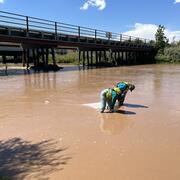
Webcams have been installed at three real-time stream-gaging sites
Webcams have been installed at three real-time stream-gaging sites
USGS Water Resources
Water information is fundamental to national and local economic well-being, protection of life and property, and effective management of the Nation’s water resources
Water information is fundamental to national and local economic well-being, protection of life and property, and effective management of the Nation’s water resources
New Mexico Water Science Center
Welcome to the U.S. Geological Survey (USGS) website for the New Mexico Water Science Center; this is your direct link to water-resource information. This site provides data and information on New Mexico's rivers and streams, groundwater, water quality, and many other water-related topics.
Storrie Lake Diversion Webcam
Storrie Lake Diversion Webcam

A webcam has been placed at the Storrie Lake Diversion near Montezuma, NM to monitor real-time conditions
New Mexico Water Science Center Featured Project:
New Mexico Water Science Center Featured Project:
Investigating PCB, PFAS, and Microplastics in Urban Runoff Contributing to the Rio Grande near Albuquerque, New Mexico
Popular Links
Popular Links
New Mexico Water Science Center's most popular pages and external links:
News
StreamStats regression equation updates for New Mexico
StreamStats regression equation updates for New Mexico
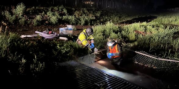
USGS Scientists Deploy to New Mexico Fire to Enhance Water Monitoring
USGS Scientists Deploy to New Mexico Fire to Enhance Water Monitoring
Studies Reveal Presence and Distribution of PFAS in New Mexico's Water Resources
Studies Reveal Presence and Distribution of PFAS in New Mexico's Water Resources
Publications
Beaver dam analogs as nature-based solutions to mitigate snowpack loss in northern New Mexico Beaver dam analogs as nature-based solutions to mitigate snowpack loss in northern New Mexico
Reductions in snow have left many streams in northern New Mexico dry or with very low flows during the summer. Base flow, defined as the contribution of groundwater to streamflow, can sustain streamflow during the summer and during drought conditions. Beaver dam analogs can be used to “slow the flow,” or increase the infiltration of rain-based runoff to replenish shallow groundwater...
Geochemical and hydrological investigations of historical data collected at the Lee Acres Landfill and Giant Bloomfield Refinery, New Mexico, 1985–2020 Geochemical and hydrological investigations of historical data collected at the Lee Acres Landfill and Giant Bloomfield Refinery, New Mexico, 1985–2020
The Lee Acres Landfill and Giant Bloomfield Refinery are adjacent properties near the City of Farmington, New Mexico, each having undergone monitoring and remediation related to historical site activities. At the landfill, site cleanup has included the installation of a capillary barrier over former liquid waste lagoons and periodic monitoring of groundwater elevations and groundwater...
Tracking the sources of metals to the San Juan River, Four Corners Region, USA: An introduction to the thematic issue Tracking the sources of metals to the San Juan River, Four Corners Region, USA: An introduction to the thematic issue
Surface water quantity and quality is important for arid and semi-arid regions where many people, including underserved and Indigenous communities, rely on a scarce resource for drinking water, irrigation, livestock and ceremonial uses. The southwestern United States, and specifically the Four Corners Region (Colorado, Arizona, New Mexico and Utah), is an example of this situation...
Science
Investigating PCB, PFAS, and Microplastics in Urban Runoff Contributing to the Rio Grande near Albuquerque, New Mexico
Stormwater outfalls in Albuquerque collect urban runoff from precipitation events which include physical materials and chemical contaminants that contribute directly into the Rio Grande. Among these contaminants are polychlorinated biphenyls (PCB), and per- and polyfluoroalkyl substances (PFAS), present in consumer and industrial products, some of which were banned decades ago but are still found...
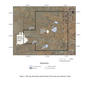
Saturated thickness mapping of the Southern High Plains Aquifer in Eastern New Mexico
The overall objective of this study is to assist Cannon AFB in understanding and interpreting current and local hydrological conditions by developing an estimate of saturated thickness of the aquifer underlying Cannon AFB and surrounding areas. The Southern High Plains aquifer is the principal source of water for Cannon AFB, the nearby towns of Clovis and Portales, and the local agriculture. The...

Decoding Harmful Algal Blooms: Unraveling the Mystery
Harmful algal blooms (HABs) are a significant environmental concern due to their potential effects on health, ecosystems, and economies. Algal toxins, which are toxic compounds produced by certain species of cyanobacteria and algae, are commonly linked to these blooms. It's important to note that algal toxins can still be present even when a bloom is not visible, highlighting the need for ongoing...
By
Ecosystems Mission Area, Contaminant Biology, Environmental Health Program, Toxic Substances Hydrology, California Water Science Center, Caribbean-Florida Water Science Center (CFWSC), Maryland-Delaware-D.C. Water Science Center, National Wildlife Health Center, Nevada Water Science Center, New England Water Science Center, New Jersey Water Science Center, New Mexico Water Science Center, South Atlantic Water Science Center (SAWSC), St. Petersburg Coastal and Marine Science Center, Upper Midwest Environmental Sciences Center, Upper Midwest Water Science Center