U.S. flag

An official website of the United States government

Images

Ohio-Kentucky-Indiana Water Science Center images.

Filter Total Items: 602
Volumetric model cross section through Allen, DeKalb, and Steuben Counties in Indiana

Volumetric model cross section through Allen, DeKalb, and Steuben Counties in Indiana created by the scientists of the Ohio-Kentucky-Indiana Water Science Center


Block diagram showing the textural classes of lithologies in the study area

Block diagram showing the textural classes of lithologies in the study area, produced by the Ohio Kentucky Indiana Water Science Center

Description: Maps showing the distribution of wells completed in glacial deposits used to create maps of hydrogeologic information and a three-dimensional volumetric model for the glacial deposits.
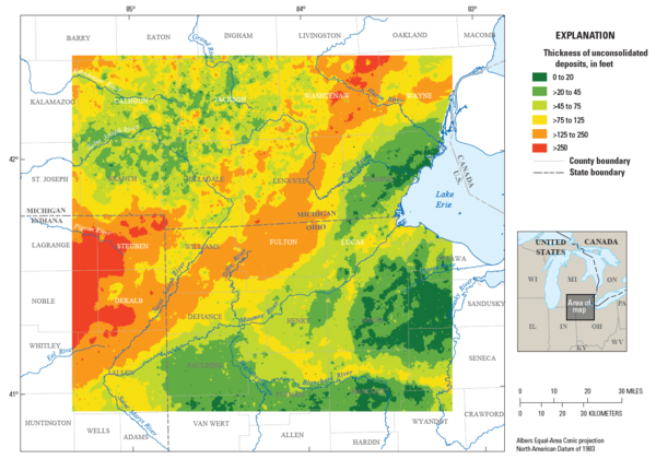
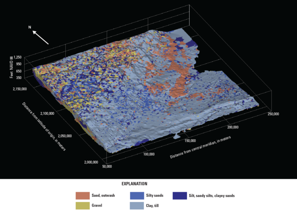
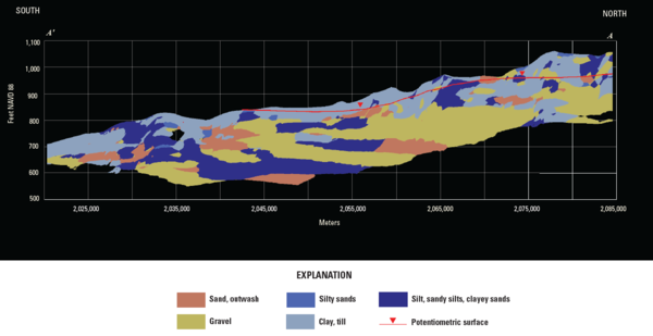
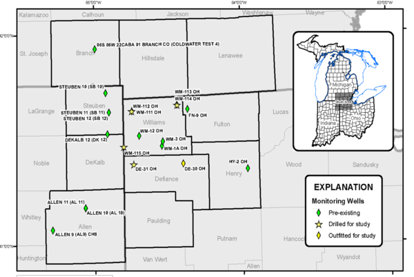
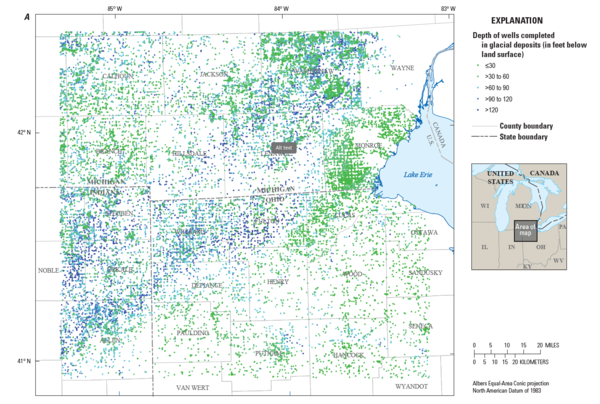
Map showing the distribution of wells in glacial deposits

Description: Maps showing the distribution of wells completed in glacial deposits used to create maps of hydrogeologic information and a three-dimensional volumetric model for the glacial deposits.

Description: Maps showing the distribution of wells completed in glacial deposits used to create maps of hydrogeologic information and a three-dimensional volumetric model for the glacial deposits.

Map showing thickness of coarse-grained deposits  Sources/Usage: USGS OKI Water Science Center, 2025
Map showing thickness of coarse-grained deposits

Map showing thickness of coarse-grained deposits created by scientists at the Ohio-Kentucky-Indiana Water Science Center


Map showing existing groundwater-level networks enhanced through adding drilled wells and converting discrete wells
Existing USGS groundwater-level networks enhanced map

Existing USGS groundwater-level networks were enhanced through: 1) the addition of newly drilled deep wells that nearly reach bedrock, and 2) conversion of discrete wells to continuous, real-time wells 

Existing USGS groundwater-level networks were enhanced through: 1) the addition of newly drilled deep wells that nearly reach bedrock, and 2) conversion of discrete wells to continuous, real-time wells 

Ben Sperl USGS
Ben_Sperl_Photo.JPG
Ben_Sperl_Photo.JPG
Ben_Sperl_Photo.JPG

Ben Sperl is a Hydrologic Technician with the Indianapolis Office of the Ohio-Kentucky-Indiana (OKI) WSC.

Ben Sperl is a Hydrologic Technician with the Indianapolis Office of the Ohio-Kentucky-Indiana (OKI) WSC.

USGS hydrologists record field notes for dip and equal-width increment (EWI) water samples as an EWI streamflow measurement
USGS hydrologists record field notes for dip and equal-width increment (EWI) water samples as an EWI streamflow measurement is made.
Current discharge from Chase Street
Current discharge from Chase Street. January 2023 Pollard

A photo of current discharge from Chase Street. This was taken in January of 2023 by Harvie Pollard.

View of the park and Chase Street flowing well
View of the park and Chase Street flowing well. January 2023 Pollard
USGS staff collecting water quality samples at USGS well B-8
USGS staff collecting water quality samples at USGS well B-8. October 2022 Pollard
USGS KY sediment lab - Kyle and Elisabeth
USGS KY sediment lab employees

Kyle Barnett and Elisabeth Hernandez analyzing sediment samples using the sand/fine break method

USGS staff conducting Borehole Geophysics at Chase Street
USGS staff conducting Borehole Geophysics at Chase Street. June 2022 Pollard
USGS groundwater monitoring well WM-111 in Williams County Ohio before and after conversion
USGS Groundwater Monitoring Well WM-111 Before and After Conversion

Picture of the USGS Groundwater Monitoring Well WM-111 in Williams County, Ohio before and after conversion to a Real-Time Monitoring well. 

USGS scientist crouching down in shallow lake collecting water sample with sampling equipment in orange raft
Water sampling at DeSoto National Wildlife Refuge

Microbiologist Erin Stelzer samples a wetland for infectious avian influenza virus at DeSoto National Wildlife Refuge, Iowa.

a brown outhouse-like structure sits beneath a bridge over the Wabash River
Super streamgage on the Wabash River near New Harmony, IN.

A super streamgage sits inside the brown structure underneath the bridge over the Wabash River linking Indiana and Illinois. The closest town is New Harmony, IN. 

USGS KY Sediment Lab - sample storage space
The Kentucky Sediment Laboratory's sample storage space, samples are stored in a temperature and light controlled environment.
USGS Kentucky Sediment Laboratory oven full of filtration crucibles to be dried
USGS Kentucky Sediment Laboratory's oven full of filtration crucibles to be dried
Perfluoroalkyl and polyfluoroalkyl substances in groundwater cover
Perfluoroalkyl and polyfluoroalkyl substances in groundwater Cover

Environ. Sci. Technol. cover featuring Perfluoroalkyl and Polyfluoroalkyl Substances in Groundwater Used as a Source of Drinking Water in the Eastern United States

USGS with DOT
USGS with Ohio DOT
USGS with Ohio DOT
USGS with Ohio DOT

The soil amendments consisted of a mixture of compost plus sand or compost plus expanded shale that were rototilled into the existing soil to depths of 4 or 6 inches. The amended soils were then topped with a compost blanket, seeded, and covered with erosion-control matting

The soil amendments consisted of a mixture of compost plus sand or compost plus expanded shale that were rototilled into the existing soil to depths of 4 or 6 inches. The amended soils were then topped with a compost blanket, seeded, and covered with erosion-control matting

Was this page helpful?