Large-scale poster describing USGS work.
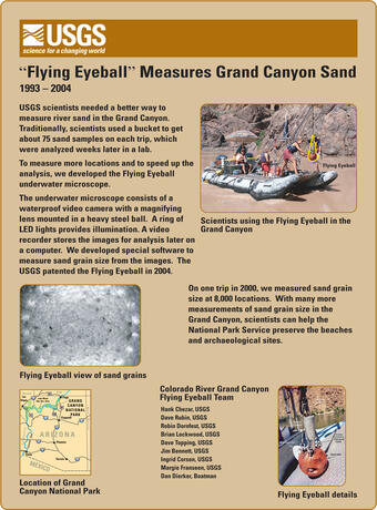
USGS scientists needed a better way to measure river sand in the Grand Canyon. Traditionally, scientists used a bucket to get about 75 sand samples on each trip, which were analyzed weeks later in a lab.

Official websites use .gov
A .gov website belongs to an official government organization in the United States.
Secure .gov websites use HTTPS
A lock () or https:// means you’ve safely connected to the .gov website. Share sensitive information only on official, secure websites.
Information about the USGS Pacific Coastal and Marine Science Center's development of an instrument called the "flying eyeball" to measure river sand, from 1993-2004.
USGS Sound Waves newsletter article:
“Sedimentologic Engineering in Grand Canyon”
Publications by USGS collaborators:
Buscombe, D., 2008, Estimation of grain size distributions and associated parameters from digital images of sediment: Sedimentary Geology, v. 210, i. 1-2, p. 1-10, doi: 10.1016/j.sedgeo.2008.06.007
Buscombe, D., and Masselink, G., 2009, Grain size information from the statistical properties of digital images of sediment: Sedimentology, v. 56, i. 2, p. 421-438, doi:10.1111/j.1365-3091.2008.00977.x
Full-scale poster image file

Large-scale poster describing USGS work.
USGS scientists needed a better way to measure river sand in the Grand Canyon. Traditionally, scientists used a bucket to get about 75 sand samples on each trip, which were analyzed weeks later in a lab.
Large-scale poster describing USGS work.
USGS scientists needed a better way to measure river sand in the Grand Canyon. Traditionally, scientists used a bucket to get about 75 sand samples on each trip, which were analyzed weeks later in a lab.
Information about the USGS Pacific Coastal and Marine Science Center's development of an instrument called the "flying eyeball" to measure river sand, from 1993-2004.
USGS Sound Waves newsletter article:
“Sedimentologic Engineering in Grand Canyon”
Publications by USGS collaborators:
Buscombe, D., 2008, Estimation of grain size distributions and associated parameters from digital images of sediment: Sedimentary Geology, v. 210, i. 1-2, p. 1-10, doi: 10.1016/j.sedgeo.2008.06.007
Buscombe, D., and Masselink, G., 2009, Grain size information from the statistical properties of digital images of sediment: Sedimentology, v. 56, i. 2, p. 421-438, doi:10.1111/j.1365-3091.2008.00977.x
Full-scale poster image file
Large-scale poster describing USGS work.
USGS scientists needed a better way to measure river sand in the Grand Canyon. Traditionally, scientists used a bucket to get about 75 sand samples on each trip, which were analyzed weeks later in a lab.
Large-scale poster describing USGS work.
USGS scientists needed a better way to measure river sand in the Grand Canyon. Traditionally, scientists used a bucket to get about 75 sand samples on each trip, which were analyzed weeks later in a lab.