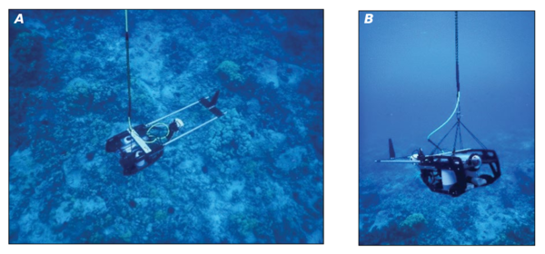
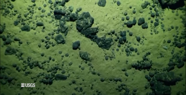
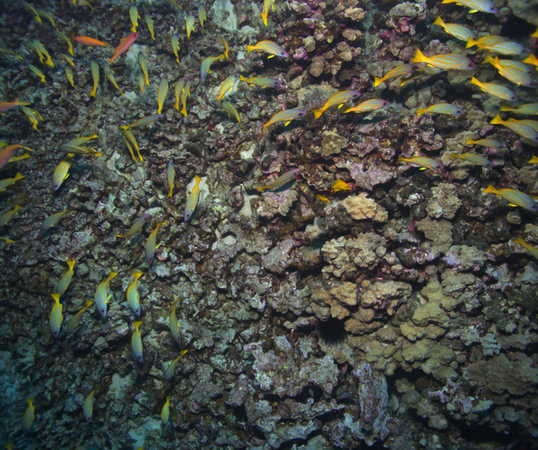
U.S. flag

An official website of the United States government

Images

Pacific Coastal and Marine Science Center images.

Filter Total Items: 1369
Underwater photos of the tethered drop-camera system
Tethered drop-camera system used to assess coral cover

Tethered drop-camera system used to assess coral cover. A) Camera system lowered below the vessel. B) Camera system held roughly 1–3 meters above the seabed. From the study Evaluation of Benthic Habitat Change within the National Historic Sites of Hawaiʻi’s Kona Coast.

Maps of spatial patterns of live coral cover and change by site at Puʻukoholā Heiau National Historic Site

Maps of spatial patterns of live coral cover and change by site at Puʻukoholā Heiau National Historic Site. A) Mean baseline survey of percentage of live coral cover. B) Mean resurvey of percentage of live coral. C) Percent change of live coral cover between the baseline and resurvey.

Map depicting Valle De Lajas and Río Loco drainage, Puerto Rico

Map depicting Valle De Lajas and Río Loco drainage, the westernmost zone of the study area. Pie charts summarizing Sr isotope mixing model results. River sediment sample locations are represented by an X, bedrock sampling locations by open circles. An infilled black rectangle shows Bahía de Guánica sediment sampling location (NS-01).

Map depicting Valle De Lajas and Río Loco drainage, the westernmost zone of the study area. Pie charts summarizing Sr isotope mixing model results. River sediment sample locations are represented by an X, bedrock sampling locations by open circles. An infilled black rectangle shows Bahía de Guánica sediment sampling location (NS-01).

Rotating x-ray computed tomography scanner with coral core

Rotating x-ray computed tomography scanner with coral core. Inset photograph shows a coral core (Orbicella spp.) inside an aluminum sleeve together with coral density standards on the top used for calibration.

Rotating x-ray computed tomography scanner with coral core. Inset photograph shows a coral core (Orbicella spp.) inside an aluminum sleeve together with coral density standards on the top used for calibration.

Scientists analyzing material extracted from sediment cores

USGS scientists collect core samples from estuaries, lakes, coasts, and marine environments to study a range of physical and chemical properties preserved in sediments over time. They process and analyze these core samples in the Pacific Coastal and Marine Science Center’s Core Labs.

USGS scientists collect core samples from estuaries, lakes, coasts, and marine environments to study a range of physical and chemical properties preserved in sediments over time. They process and analyze these core samples in the Pacific Coastal and Marine Science Center’s Core Labs.

Scientists wrapping a split sediment core in plastic

USGS scientists collect core samples from estuaries, lakes, coasts, and marine environments to study a range of physical and chemical properties preserved in sediments over time. They process and analyze these core samples in the Pacific Coastal and Marine Science Center’s Core Labs.

USGS scientists collect core samples from estuaries, lakes, coasts, and marine environments to study a range of physical and chemical properties preserved in sediments over time. They process and analyze these core samples in the Pacific Coastal and Marine Science Center’s Core Labs.

Scientists sub-sampling split sediment cores
Scientists sub-sampling split sediment cores_2

USGS scientists collect core samples from estuaries, lakes, coasts, and marine environments to study a range of physical and chemical properties preserved in sediments over time. They process and analyze these core samples in the Pacific Coastal and Marine Science Center’s Core Labs.

USGS scientists collect core samples from estuaries, lakes, coasts, and marine environments to study a range of physical and chemical properties preserved in sediments over time. They process and analyze these core samples in the Pacific Coastal and Marine Science Center’s Core Labs.

Scientists analyzing material extracted from sediment cores
Scientists analyzing material extracted from sediment cores_3

USGS scientists collect core samples from estuaries, lakes, coasts, and marine environments to study a range of physical and chemical properties preserved in sediments over time. They process and analyze these core samples in the Pacific Coastal and Marine Science Center’s Core Labs. 

USGS scientists collect core samples from estuaries, lakes, coasts, and marine environments to study a range of physical and chemical properties preserved in sediments over time. They process and analyze these core samples in the Pacific Coastal and Marine Science Center’s Core Labs. 

Scientists separating a sediment core split lengthwise
Scientists separating a sediment core split lengthwise_2

USGS scientists collect core samples from estuaries, lakes, coasts, and marine environments to study a range of physical and chemical properties preserved in sediments over time. They process and analyze these core samples in the Pacific Coastal and Marine Science Center’s Core Labs.

USGS scientists collect core samples from estuaries, lakes, coasts, and marine environments to study a range of physical and chemical properties preserved in sediments over time. They process and analyze these core samples in the Pacific Coastal and Marine Science Center’s Core Labs.

Scientists separating a sediment core split lengthwise

USGS scientists collect core samples from estuaries, lakes, coasts, and marine environments to study a range of physical and chemical properties preserved in sediments over time. They process and analyze these core samples in the Pacific Coastal and Marine Science Center’s Core Labs.

USGS scientists collect core samples from estuaries, lakes, coasts, and marine environments to study a range of physical and chemical properties preserved in sediments over time. They process and analyze these core samples in the Pacific Coastal and Marine Science Center’s Core Labs.

Scientists sub-sampling split sediment cores

USGS scientists collect core samples from estuaries, lakes, coasts, and marine environments to study a range of physical and chemical properties preserved in sediments over time. They process and analyze these core samples in the Pacific Coastal and Marine Science Center’s Core Labs. 

USGS scientists collect core samples from estuaries, lakes, coasts, and marine environments to study a range of physical and chemical properties preserved in sediments over time. They process and analyze these core samples in the Pacific Coastal and Marine Science Center’s Core Labs. 

Scientist retrieving a sediment core from the refrigerated core repository

USGS scientists collect core samples from estuaries, lakes, coasts, and marine environments to study a range of physical and chemical properties preserved in sediments over time. They process and analyze these core samples in the Pacific Coastal and Marine Science Center’s Core Labs. 

USGS scientists collect core samples from estuaries, lakes, coasts, and marine environments to study a range of physical and chemical properties preserved in sediments over time. They process and analyze these core samples in the Pacific Coastal and Marine Science Center’s Core Labs. 

Scientists splitting a sediment core with the GeoTek core splitter
Scientists splitting a sediment core with the GeoTek core splitter_2

USGS scientists collect core samples from estuaries, lakes, coasts, and marine environments to study a range of physical and chemical properties preserved in sediments over time. They process and analyze these core samples in the Pacific Coastal and Marine Science Center’s Core Labs.

USGS scientists collect core samples from estuaries, lakes, coasts, and marine environments to study a range of physical and chemical properties preserved in sediments over time. They process and analyze these core samples in the Pacific Coastal and Marine Science Center’s Core Labs.

Scientists splitting a sediment core with the GeoTek core splitter

USGS scientists collect core samples from estuaries, lakes, coasts, and marine environments to study a range of physical and chemical properties preserved in sediments over time. They process and analyze these core samples in the Pacific Coastal and Marine Science Center’s Core Labs.

USGS scientists collect core samples from estuaries, lakes, coasts, and marine environments to study a range of physical and chemical properties preserved in sediments over time. They process and analyze these core samples in the Pacific Coastal and Marine Science Center’s Core Labs.

Was this page helpful?