
Linking climate variability to shoreline change in the Pacific Northwest
Sandy beaches worldwide are constantly shifting, sometimes subtly, sometimes dramatically. Now, new research focused on the U.S. Pacific Northwest coast finds that climate patterns such as El Niño and La Niña don’t just influence beaches seasonally—they shape their year-to-year evolution in measurable and predictable ways.
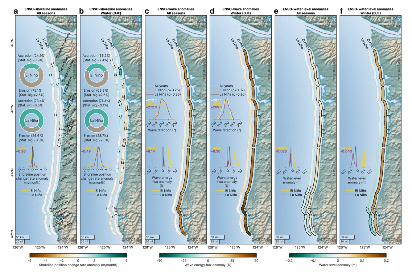
Analyzing 40 years of satellite data from 1984 to 2024, scientists examined roughly 750 kilometers of coastline spanning Washington and Oregon. Using high-resolution shoreline mapping derived from Landsat imagery across more than 10,000 shore-perpendicular transects, the study reconstructed how beaches expanded and eroded over four decades, linking those changes directly to large-scale climate cycles in the Pacific Ocean.
El Niño Erodes, La Niña Builds
The study confirms what many coastal scientists have long observed during dramatic winters: strong El Niño-Southern Oscillation (ENSO) events significantly reshape shorelines.
- During strong El Niño years, 75.1% of measured beach transects showed erosion.
- During strong La Niña years, 73.4% showed accretion, or beach growth.
El Niño winters typically bring higher water levels and more energetic wave conditions to the Pacific Northwest, accelerating sand loss. La Niña years often produce conditions more favorable for sand accumulation.
Beyond Seasonal Swings, a Long-Term Signal
Using an analytical method called Convergent Cross Mapping—designed to detect causal relationships in complex systems—the team demonstrated for the first time that ENSO causes significant changes in seasonal and interannual shoreline erosion.
They also identified a second, longer-term driver: the Pacific Decadal Oscillation (PDO). Unlike ENSO, which operates on seasonal timescales, PDO shifts occur over decades.
The study found that:
- ENSO significantly influences interannual shoreline behavior in 95% of littoral cells (coastal sediment-sharing regions).
- PDO influences were statistically significant in 100% of littoral cells.
- Fluctuations in regional water levels play a critical mediating role in both climate-beach connections.
This establishes that Pacific climate variability leaves a persistent imprint on shoreline position—not just during headline-making storm years, but across decades.
USGS Research Oceanographer Dr. Sean Vitousek said of the study, “Mohsen [Taherkhani; study's first author]’s research is the first application that I’ve seen in coastal science to use Convergent Cross Mapping to explore the causes and effects of shoreline erosion. We now have a tool that goes beyond simple correlation-based analyses to understand erosion patterns we’re experiencing across the US West Coast.”
Why It Matters
Sandy beaches act as natural buffers against coastal hazards, absorbing wave energy and protecting infrastructure and ecosystems. Understanding how and why shorelines migrate over time is critical for:
- Coastal hazard assessments
- Sediment management planning
- Infrastructure siting
- Climate adaptation strategies
By clarifying how major Pacific climate modes shape beach morphology from season-to-season and year-to-year, the study gives coastal managers stronger scientific footing for long-term planning.
Related

Remote Sensing Coastal Change
Related