U.S. flag

An official website of the United States government

Images

Below are images associated with SBSC's science and staff. Images appear according to the year they were taken. To search, type a keyword or select a year from the dropdown menu. Or, click through the pages using the arrows at the bottom of the page. 

Filter Total Items: 641
A sandbar/sand dune along the Colorado River in Grand Canyon prior to vegetation removal
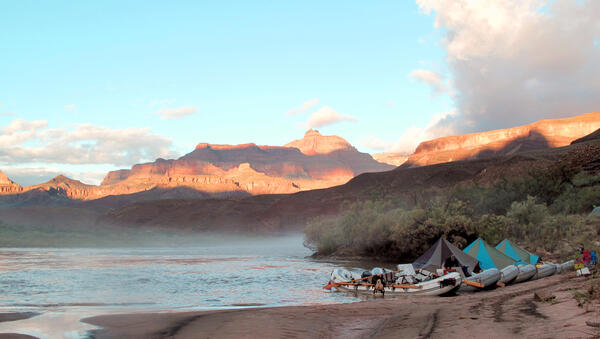
A sandbar/sand dune along the Colorado River near an archaeological site in Grand Canyon prior to vegetation removal

A research and monitoring area at a sandbar/sand dune near an archaeological site along the Colorado River in Grand Canyon before encroaching vegetation removal. Photo courtesy of Joel Sankey, USGS, Southwest Biological Science Center, Grand Canyon Monitoring and Research Center.

Photograph of an archaeological site threatened by gully erosion of sediment on a river terrace in Grand Canyon National Park
An archaeological site in Grand Canyon National Park with nearby gully erosion

A partially-buried archaeological site in Grand Canyon National Park threatened by gully erosion of sediment on a river terrace near the Colorado River. Photo by Helen Fairley, USGS, SBSC, Grand Canyon Monitoring and Research Center, May 2019.


A partially-buried archaeological site in Grand Canyon National Park threatened by gully erosion of sediment on a river terrace near the Colorado River. Photo by Helen Fairley, USGS, SBSC, Grand Canyon Monitoring and Research Center, May 2019.


A Park Service land manager and a USGS scientist install a flowering plant.
Working Together to Support Pollinators

The USGS RAMPS program partnered with Saguaro National Park and the NPS Sonoran Desert Network Inventory and Monitoring Program to share knowledge about techniques for improving pollinator habitat at the NPS Desert Research and Learning Center in Tucson, AZ.

The USGS RAMPS program partnered with Saguaro National Park and the NPS Sonoran Desert Network Inventory and Monitoring Program to share knowledge about techniques for improving pollinator habitat at the NPS Desert Research and Learning Center in Tucson, AZ.

A woman waters newly seeded trays in a greenhouse while her colleague looks on.
Navajo Nation Greenhouse

The Restoration Assessment and Monitoring Program for the Southwest (RAMPS) is working with the Navajo Nation Natural Heritage Program's Dine Native Plant Program to increase tribal native seed sovereignty by developing educational workshops, restoration experiments, and opportunities for famers to grow native seeds for restoration.

The Restoration Assessment and Monitoring Program for the Southwest (RAMPS) is working with the Navajo Nation Natural Heritage Program's Dine Native Plant Program to increase tribal native seed sovereignty by developing educational workshops, restoration experiments, and opportunities for famers to grow native seeds for restoration.

Inside view of research boat on Lake Powell

Inside view of a research boat on Lake Powell. SBSC conducts water quality monitoring in collaboration with the U.S. Bureau of Reclamation. 

Inside view of a research boat on Lake Powell. SBSC conducts water quality monitoring in collaboration with the U.S. Bureau of Reclamation. 

Panorama of Lake Powell with research boat

Panorama of Lake Powell with water quality monitoring research boat. Photo by SBSC, 2019.

Wind energy solar power photos blended
Wind energy facility and a solar power tower - cropped

Original photos by P. Cryan (wind farm) and M. Huso (solar power tower), USGS. Blended photo created by S. Kemp, USGS.

A map with an area marked in colors to define soil maps in the Colorado River Basin
30m resolution soil map for the Colorado River Basin, Four Corners region
Boats along a beach on the Colorado River in Grand Canyon

View of the Colorado River in Eastern Grand Canyon below Basalt Creek, Grand Canyon National Park. Photo by Mike Moran, USGS.

Aquatic insect eggs laid on a rock at the water line in the Colorado River in Grand Canyon
Aquatic insect eggs just above the waterline along the Colorado River in Grand Canyon

Aquatic insect eggs are laid on rocks just at the waterline along the Colorado River in Grand Canyon and here they are exposed as the water levels fluctuate. Aquatic insects are an important part of the food base in the Colorado River, providing food for fish, bats, and birds. Aquatic insects need to stay damp to survive and hatch.

Aquatic insect eggs are laid on rocks just at the waterline along the Colorado River in Grand Canyon and here they are exposed as the water levels fluctuate. Aquatic insects are an important part of the food base in the Colorado River, providing food for fish, bats, and birds. Aquatic insects need to stay damp to survive and hatch.

Biocrusts with lichen

Mature biocrust with lichen. Photo taken by SBSC during surveys, 2018, courtesy of Erika Geiger.

Mature biocrust with lichen. Photo taken by SBSC during surveys, 2018, courtesy of Erika Geiger.

Well pad reclamation experiment

Well pad reclamation experiment, Vernal, Utah, December 8, 2018. Photo by Rebecca Mann, USGS, SBSC.

Well pad reclamation experiment, Vernal, Utah, December 8, 2018. Photo by Rebecca Mann, USGS, SBSC.

Two women write on a white board.
Grassland Climate Adaptation Project

Working to develop climate adaptation actions on National Park Service lands on the Colorado Plateau and 4-corners region.

Working to develop climate adaptation actions on National Park Service lands on the Colorado Plateau and 4-corners region.

Four pits filled with water.
RestoreNet treatments

RestoreNet locations are testing commonly used restoration techniques, including pitting, mulching, and above-ground micro sites. Here, pits have filled with water, illustrating how this technique increases soil moisture by capturing rainwater.

RestoreNet locations are testing commonly used restoration techniques, including pitting, mulching, and above-ground micro sites. Here, pits have filled with water, illustrating how this technique increases soil moisture by capturing rainwater.

Mulch treatment
RestoreNet treatments

RestoreNet locations are testing commonly used restoration techniques, including pitting, mulching, and above-ground micro sites. This photo shows the mulching treatment, which can increase soil moisture and lead to higher plant survival under some conditions.

RestoreNet locations are testing commonly used restoration techniques, including pitting, mulching, and above-ground micro sites. This photo shows the mulching treatment, which can increase soil moisture and lead to higher plant survival under some conditions.

Wire crosses, called ConMods installed at a RestoreNet site.
RestoreNet treatments

RestoreNet locations are testing commonly used restoration techniques, including pitting, mulching, and above-ground micro sites. Here, metal crosses create an above-ground microsite that can increase soil moisture by providing shade and collecting debris under some conditions.

RestoreNet locations are testing commonly used restoration techniques, including pitting, mulching, and above-ground micro sites. Here, metal crosses create an above-ground microsite that can increase soil moisture by providing shade and collecting debris under some conditions.

Criollo cows run into a corral with autumn yellow trees in the background in Canyonlands
Criollo cattle, a heritage breed, at Canyonlands Research Center, Utah

Criollo cattle, a heritage breed of cows, at Canyonlands Research Center, Utah. Photo by Mike Duniway, USGS, SBSC.

Two cows stand in a corral in Utah, on the Colorado Plateau, with red rock in the background
Criollo heritage cattle in a corral at Canyonlands Research Center, Utah

Criollo heritage cattle stand in a corral at Canyonlands Research Center, Utah. Criollo cows are descended from Iberian, or Spanish, stock brought to Mexico hundreds of years ago. They are hardier than Angus cattle and better suited to dry climates.

Criollo heritage cattle stand in a corral at Canyonlands Research Center, Utah. Criollo cows are descended from Iberian, or Spanish, stock brought to Mexico hundreds of years ago. They are hardier than Angus cattle and better suited to dry climates.

A kit fox walks through the grass next to a solar panel at Panoche Solar Farm
A kit fox at Panoche Solar Farm

San Joaquin kit fox (Vulpes macrotis mutica) with a radio collar inside the Panoche Solar Farm in the San Joaquin Desert. Photo by Tory Westall (Stanislaus State).

Information about species and solar facilities can be found in this paper:

San Joaquin kit fox (Vulpes macrotis mutica) with a radio collar inside the Panoche Solar Farm in the San Joaquin Desert. Photo by Tory Westall (Stanislaus State).

Information about species and solar facilities can be found in this paper:

Glen Canyon Dam jet tubes releasing water into the Colorado River for a high flow experiment.
Glen Canyon Dam jet tubes releasing water for a high flow experiment

Looking down on Glen Canyon Dam jet tubes releasing water into the Colorado River for a November 2018 high flow experiment. The increase in flow of the Colorado River downstream of the dam mobilizes sand at the bottom of the river and that sand rebuilds sandbars in Grand Canyon.

Looking down on Glen Canyon Dam jet tubes releasing water into the Colorado River for a November 2018 high flow experiment. The increase in flow of the Colorado River downstream of the dam mobilizes sand at the bottom of the river and that sand rebuilds sandbars in Grand Canyon.

Was this page helpful?