
Riparian Vegetation
Riparian Vegetation
Filter Total Items: 18

Lake Powell Research
Lake Powell is a large arid reservoir that represents about 70% of the water storage capacity for the Upper Colorado River Basin. It is the second largest reservoir in the United States by capacity (second only to Lake Mead). Lake Powell is an oligotrophic reservoir, which means that nutrient concentrations and algal production are generally low. This often results in very clear-water conditions...

SBSC: Providing Unbiased Actionable Science & Information to Support Natural Resource Management Needs of the U.S. & Department of the Interior Priorities
The U.S. Geological Survey Southwest Biological Science Center (SBSC) is uniquely positioned in the Colorado River Basin to provide sound information, specialized expertise, and innovative tools to support the management and sustained use of natural resources on public and Tribal lands in the Southwest U.S.
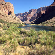
Vegetation monitoring: How one square meter can tell the story of 255 river miles along the Colorado River
The goal of SBSC's Grand Canyon Monitoring and Research Center’s (GCMRC) riparian vegetation monitoring program is to assess changes and trends in plant species composition and cover and relate those changes to river hydrology, climate, geomorphology, and the operations of Glen Canyon Dam.
Riparian Vegetation in Grand Canyon: An Overview
Riparian plant communities, associated with rivers and streams, are ecologically and culturally important areas in the southwestern U.S. Despite covering less than 2% of the land area in the southwest, the resources provided by these communities make them valuable to wildlife, the public, scientists, and resource managers.

SBSC science supports invasive species management
Invasive species can harm ecosystems, increase wildfires, damage forests, and outcompete native species. The US Geological Survey's Southwest Biological Science Center conducts research that provides our federal and state partners, cooperators and land managers with the tools, data and strategies to enhance biosecurity management. Scroll through the information below to read about different SBSC...

Colorado River Basin Science
The Grand Canyon Monitoring and Research Center, a branch of the Southwest Biological Science Center, conducts scientific assessments of the Colorado River in Grand Canyon, focused primarily on Lake Powell and the river ecosystem downstream of Glen Canyon Dam. On this page, we'd like to share related interactive tools and projects by other USGS Centers that cover science across the upper and lower...

Rio Grande/Rio Bravo Research
The Rio Grande/Rio Bravo (hereafter referred to as the Rio Grande) in the Big Bend region of Texas, USA, and Chihuahua and Coahuila, Mexico, has substantially narrowed since the early 1900s. This narrowing has been caused by the construction and operation of dams and irrigation diversions in upstream reaches of the Rio Grande in the U.S. and the Rio Conchos in Mexico that has reduced flows without...

SBSC Tribal Partnerships
The Southwest Biological Science Center (SBSC) conducts and provides scientific information as part of our mission and Federal Trust Responsibility to strengthen relationships and build partnerships with sovereign tribal nations. Here, we highlight a few examples of projects with tribal partners.

GCMRC Science Informs Hydropower and Invasive Species Management
USGS Southwest Biological Science Center's Grand Canyon Monitoring and Research Center provided scientific expertise to evaluate potential effects of reservoir management on various resources in Lake Powell and Grand Canyon. This information, published in a cooperator report, was requested and used by the Bureau of Reclamation for decision-making on water flows from Glen Canyon Dam.

Grand Canyon Monitoring and Research Projects
The Grand Canyon Monitoring and Research Center currently functions under a Triennial Work Plan (TWP) which is thoroughly reviewed and vetted both internally within the Center and through the GCDAMP Technical Work Group (TWG) and the Adaptive Management Work Group (AMWG). These advisory panels have been a part of the Glen Canyon Dam adaptive management process since the inception of the GCDAMP...

Airborne Remote Sensing in Grand Canyon
A high-resolution image collection in 2021 will be the most recent in a rich archive of aerial imagery that is used to track changes of the Colorado River in the Grand Canyon. Imagery will be acquired from an airplane in Grand Canyon National Park along the Colorado River corridor and the Little Colorado River starting Memorial Day weekend and continuing through the first week of June 2021. This...

Is timing really everything? Evaluating Resource Response to Spring Disturbance Flows
Glen Canyon Dam has altered ecological processes of the Colorado River in Grand Canyon. Before the dam was built, the Colorado River experienced seasonable variable flow rates, including springtime flooding events. These spring floods scoured the river bottom and enhanced natural processes that sustained the Colorado River ecosystem. Since the dam’s construction in 1963, springtime floods have...