
Illustration depicting phosphorus loading in shallow lakes represented by Lake Winnebago, Wisconsin.
Images
Upper Midwest Water Science Center images.
Filter Total Items: 548

Phosphorus Loading in Shallow Lakes
Illustration depicting phosphorus loading in shallow lakes represented by Lake Winnebago, Wisconsin.

Havasupai Falls
Part of a series of small inset drawings, this is a top view of Havasupai Falls, its aquamarine colored water is highly recognizable and it is a site of tribal, cultural, and recreational significance to the greater Grand Canyon region.
Part of a series of small inset drawings, this is a top view of Havasupai Falls, its aquamarine colored water is highly recognizable and it is a site of tribal, cultural, and recreational significance to the greater Grand Canyon region.

Road Salt on Milwaukee Riverwalk Boardwalk
Road salt de-icer left over from an ice event on Milwaukee Riverwalk boardwalk near East Clybourn Street, looking south towards highway 794.
Road salt de-icer left over from an ice event on Milwaukee Riverwalk boardwalk near East Clybourn Street, looking south towards highway 794.

Phosphorus Loading and Water Quality in Green Lake
Phosphorus Loading and Water Quality in Green LakeGreen Lake is the deepest natural lake in Wisconsin. The drawing relates the water-quality response of Green Lake, with emphasis on the Metalimnetic Oxygen Minima, to total phosphorus loading from its watershed. The drawing depicts data collection, analysis, modeling, and real-time monitoring.

Horn Creek Sign
Part of a series of small inset drawings, this is of a sign located near Horn Creek. The Creek is contaminated with high levels of Uranium. Sign states: "Horn Creek, Danger, Contaminated Water, Do Not Drink! Water in Horn Creek exceeds EPA health standards for radioactivity"
Part of a series of small inset drawings, this is of a sign located near Horn Creek. The Creek is contaminated with high levels of Uranium. Sign states: "Horn Creek, Danger, Contaminated Water, Do Not Drink! Water in Horn Creek exceeds EPA health standards for radioactivity"
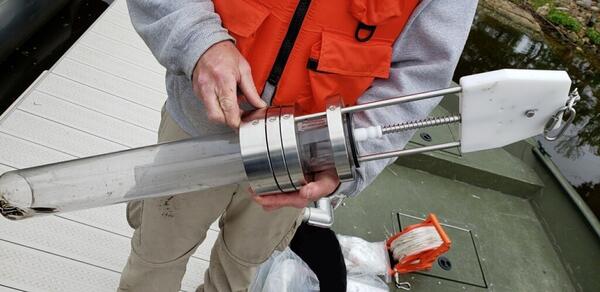
Sediment corer being prepared for use on Gruber’s Grove Bay, Wisconsin
Sediment corer being prepared for use on Gruber’s Grove Bay, WisconsinA USGS scientist holds a sediment corer being prepared for use on Gruber’s Grove Bay on Lake Wisconsin, Wisconsin.
Sediment corer being prepared for use on Gruber’s Grove Bay, Wisconsin
Sediment corer being prepared for use on Gruber’s Grove Bay, WisconsinA USGS scientist holds a sediment corer being prepared for use on Gruber’s Grove Bay on Lake Wisconsin, Wisconsin.

The Big Picture: Grand Canyon and Uranium Mining
Created for a fact sheet on the implications of breccia pipe Uranium mining in the Grand Canyon region, this drawing packs a significant amount of information into a single image.
Created for a fact sheet on the implications of breccia pipe Uranium mining in the Grand Canyon region, this drawing packs a significant amount of information into a single image.

Wildfire burn site located in Oregon
This is a landscape photo of a wildfire burn site located in Oregon, USA. Photo taken in November of 2021.
This is a landscape photo of a wildfire burn site located in Oregon, USA. Photo taken in November of 2021.
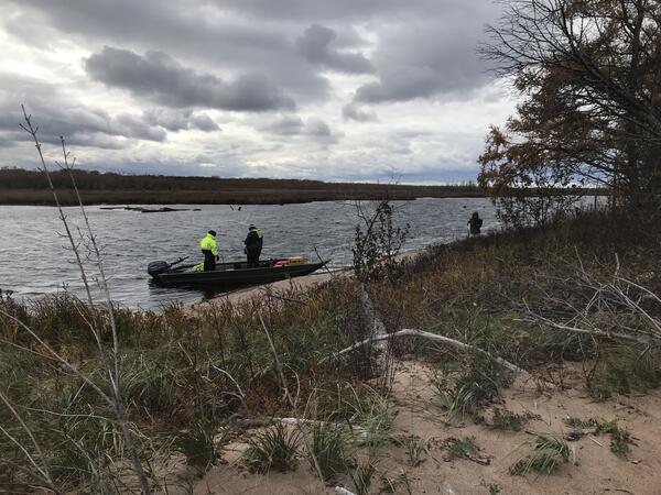
Slough at Lake Superior
Ed Wiggins, Mariah Hipsher, and Lucas Stevens check sensors in the Sloughs on the Lake Superior shoreline, at the Mashkiiziibii (Bad River) Reservation.
Ed Wiggins, Mariah Hipsher, and Lucas Stevens check sensors in the Sloughs on the Lake Superior shoreline, at the Mashkiiziibii (Bad River) Reservation.

Collecting water sample at edge of Green Lake, Minnesota (Kandiyohi County)
Collecting water sample at edge of Green Lake, Minnesota (Kandiyohi County)Scientist Emeritus Dave Krabbenhoft collecting water sample at edge of Green Lake, Minnesota (Kandiyohi County).
Collecting water sample at edge of Green Lake, Minnesota (Kandiyohi County)
Collecting water sample at edge of Green Lake, Minnesota (Kandiyohi County)Scientist Emeritus Dave Krabbenhoft collecting water sample at edge of Green Lake, Minnesota (Kandiyohi County).

Zebra Mussels on shore of Green Lake, Minnesota (Kandiyohi County)
Zebra Mussels on shore of Green Lake, Minnesota (Kandiyohi County)Close up of the Green Lake, Minnesota (Kandiyohi County) shoreline showing zebra mussels washed up on shore, October 2021
Zebra Mussels on shore of Green Lake, Minnesota (Kandiyohi County)
Zebra Mussels on shore of Green Lake, Minnesota (Kandiyohi County)Close up of the Green Lake, Minnesota (Kandiyohi County) shoreline showing zebra mussels washed up on shore, October 2021

Lauren Privette
Lauren Privette holds a large ice block from a frozen lake at Treehaven education center in northern Wisconsin.
Lauren Privette holds a large ice block from a frozen lake at Treehaven education center in northern Wisconsin.

Biologist loads water samples into centrifuge for processing
Biologist loads water samples into centrifuge for processingBiologist Alexei Rose processes a water sample for analysis of infectious avian influenza virus at the Michigan Bacteriological Research Laboratory in Lansing, Michigan.
Biologist loads water samples into centrifuge for processing
Biologist loads water samples into centrifuge for processingBiologist Alexei Rose processes a water sample for analysis of infectious avian influenza virus at the Michigan Bacteriological Research Laboratory in Lansing, Michigan.

The new bike lane along Niagara Street, Buffalo, NY.
The new bike lane along Niagara Street, Buffalo, NY.The new bike lane along Niagara Street, Buffalo, NY.
The new bike lane along Niagara Street, Buffalo, NY.
The new bike lane along Niagara Street, Buffalo, NY.The new bike lane along Niagara Street, Buffalo, NY.

Wisconsin Sample Collection
Laura Hubbard hard at work collecting samples across the state of Wisconsin to send to the Leetown Lab.
Laura Hubbard hard at work collecting samples across the state of Wisconsin to send to the Leetown Lab.

Samples in Transit
John Steiner preparing to bring wastewater samples to FedEx for shipping.
John Steiner preparing to bring wastewater samples to FedEx for shipping.

NPS Technician collects an algal bloom sample from Kabetogama Lake, MN07.JPG
NPS Technician collects an algal bloom sample from Kabetogama Lake, MN07.JPGA National Park Service Technician collects a water sample from an algal bloom at Voyageurs National Park, MN.
NPS Technician collects an algal bloom sample from Kabetogama Lake, MN07.JPG
NPS Technician collects an algal bloom sample from Kabetogama Lake, MN07.JPGA National Park Service Technician collects a water sample from an algal bloom at Voyageurs National Park, MN.
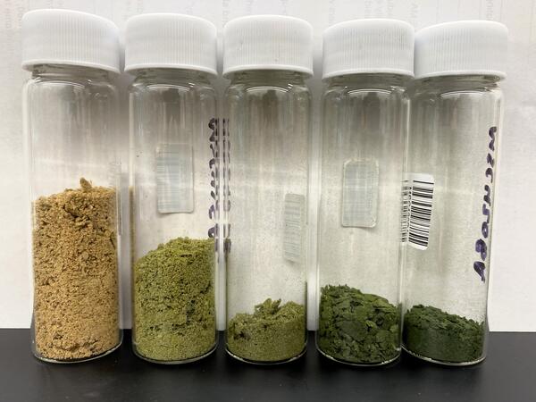
Plankton samples collected from different monthly collections in Lake Mendota, Wisconsin
Plankton samples collected from different monthly collections in Lake Mendota, WisconsinFive clear glass bottles contain samples of dry plankton, ranging in color from brown to dark green. Plankton samples were collected from different monthly collections in Lake Mendota, Wisconsin. The color gradient highlights how plankton communities can rapidly change over the course of spring to summer.
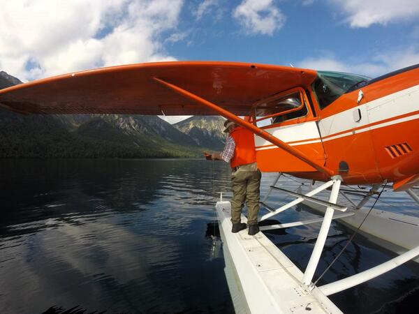
Water sampling from a seaplane in Alaska
A USGS scientist collects a water sample from Teal Lake in Alaska, using a Go-Flo bottle, while standing on the float of a seaplane.
A USGS scientist collects a water sample from Teal Lake in Alaska, using a Go-Flo bottle, while standing on the float of a seaplane.

Discussing the design of a bioswale at the Green Tech Station on the north side of Milwaukee, Wisconsin
Discussing the design of a bioswale at the Green Tech Station on the north side of Milwaukee, WisconsinJustin Hegarty (Reflo Sustainable Water Solutions) and Dr. Tony Parolari (Marquette University) discussing the design of a bioswale at the Green Tech Station on Milwaukee’s north side.

Tahquamenon Falls
Tahquamenon Falls Upper Falls, Tahquamenon State Park downstream of streamgage 04045500, Tahquamenon River Near Paradise, MI.
Tahquamenon Falls Upper Falls, Tahquamenon State Park downstream of streamgage 04045500, Tahquamenon River Near Paradise, MI.