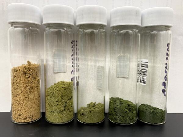
U.S. flag

An official website of the United States government

Images

Upper Midwest Water Science Center images.

Filter Total Items: 548
Helicopter in air towing large hexagonal hoop by wire
Helicopter towing geophysical survey hoop via slingload for airborne electromagnetic (AEM) survey

Helicopter with geophysical equipment loop deployed below it via slingload. In January 2021 a helicopter carried an airborne electromagnetic induction sensor over parts of northeastern Wisconsin as part of a USGS study to map the aquifers in the region.

Person standing inside large survey hoop talking to two others standing outside of hoop
Explanation of electromagnetic geophysical survey equipment

A SkyTEM team member explains technology behind geophysical equipment loop to USGS employees. In January 2021 a helicopter carried an airborne electromagnetic induction sensor over parts of northeastern Wisconsin as part of a USGS study to map the aquifers in the region.

A SkyTEM team member explains technology behind geophysical equipment loop to USGS employees. In January 2021 a helicopter carried an airborne electromagnetic induction sensor over parts of northeastern Wisconsin as part of a USGS study to map the aquifers in the region.

Helicopter hovering above ground with geophysical equipment loop on ground
Helicopter with electromagnetic geophysical equipment loop deployed below it via slingload taking off for survey flight

Helicopter with geophysical equipment loop deployed below it via slingload taking off for survey flight. In January 2021 a helicopter carried an airborne electromagnetic induction sensor over parts of northeastern Wisconsin as part of a USGS study to map the aquifers in the region.

Geophysical equipment loop for electromagnetic survey on ground prior to liftoff by helicopter

Geophysical equipment loop for electromagnetic survey on ground prior to liftoff by helicopter. In January 2021 a helicopter carried an airborne electromagnetic induction sensor over parts of northeastern Wisconsin as part of a USGS study to map the aquifers in the region.

Geophysical equipment loop for electromagnetic survey on ground prior to liftoff by helicopter. In January 2021 a helicopter carried an airborne electromagnetic induction sensor over parts of northeastern Wisconsin as part of a USGS study to map the aquifers in the region.

Geophysical survey hoop resting on snowy ground
Electromagnetic geophysical survey hoop

Geophysical equipment survey hoop resting on ground in between flights. In January 2021 a helicopter carried an airborne electromagnetic induction sensor over parts of northeastern Wisconsin as part of a USGS study to map the aquifers in the region.

Geophysical equipment survey hoop resting on ground in between flights. In January 2021 a helicopter carried an airborne electromagnetic induction sensor over parts of northeastern Wisconsin as part of a USGS study to map the aquifers in the region.

Straight-forward cross sectional schematic of the different types of mill tailing covers
Evapotranspiration Uranium Mill Tailing Covers

The U.S. Nuclear Regulatory Commission (NRC) regulates uranium mill tailings under the Uranium Mill Tailings Control Act of 1978. This drawing is a straight-forward cross sectional schematic of the different types of mill tailing covers.

The U.S. Nuclear Regulatory Commission (NRC) regulates uranium mill tailings under the Uranium Mill Tailings Control Act of 1978. This drawing is a straight-forward cross sectional schematic of the different types of mill tailing covers.

Colored pencil illustration of Grand Canyon with emphasis on uranium mining
A Grand Canyon View
A Grand Canyon View
A Grand Canyon View

This image was drawn for a fact sheet on Uranium mining in the Grand Canyon region, but was ultimately unused.  It still has utility to serve as inspiration to those who want to form ideas on how their science can be represented.  The image is quite literally, a view into the Grand Canyon.  But on a deeper level also is a conglomerate of both the geol

This image was drawn for a fact sheet on Uranium mining in the Grand Canyon region, but was ultimately unused.  It still has utility to serve as inspiration to those who want to form ideas on how their science can be represented.  The image is quite literally, a view into the Grand Canyon.  But on a deeper level also is a conglomerate of both the geol

ADCP floating in river tethered to cable with fall foliage in background
Acoustic Doppler current profiler (ADCP) measures stream velocity at streamgage 04045500, Tahquamenon River Near Paradise, MI
Woman wearing hat, mask and gloves, holding a duck while banding its leg
Holding duck while banding

Research hydrologist Laura Hubbard got to experience being a wildlife biologist for a few hours, holding her first duck as part of a planned Minnesota Department of Natural Resources banding in August 2020 near Thief River Falls, MN. The banding was part of research to understand the persistence of influenza A viruses in the environment.

Research hydrologist Laura Hubbard got to experience being a wildlife biologist for a few hours, holding her first duck as part of a planned Minnesota Department of Natural Resources banding in August 2020 near Thief River Falls, MN. The banding was part of research to understand the persistence of influenza A viruses in the environment.

PEST++ data visualization
Visualization of an ensemble of solutions for PEST++

The left axis is a visualization of an ensemble of solutions (crosses and dashed lines) iteratively moving down gradient on an objective function surface (color flood) in 2-D parameters space, with the associated prior (gray) and posterior (blue) parameter marginal distributions shown on the two right stacked axes.

The left axis is a visualization of an ensemble of solutions (crosses and dashed lines) iteratively moving down gradient on an objective function surface (color flood) in 2-D parameters space, with the associated prior (gray) and posterior (blue) parameter marginal distributions shown on the two right stacked axes.

Hydrologist measuring streamflow standing on a bridge, holding the end of a rope attached to an ADCP in a flowing brown river
Hydrologic Technician measuring streamflow using ADCP in Wisconsin

Hydrologic Technician Matt Bach measuring streamflow day after a rain event at USGS streamgage 04085078, DUTCHMAN CREEK AT HANSEN RD AT ASHWAUBENON, WI, using an Acoustic Doppler Current Profiler (ADCP). The ADCP measures water currents by transmitting "pings" of sound at a constant frequency into the water.

Hydrologic Technician Matt Bach measuring streamflow day after a rain event at USGS streamgage 04085078, DUTCHMAN CREEK AT HANSEN RD AT ASHWAUBENON, WI, using an Acoustic Doppler Current Profiler (ADCP). The ADCP measures water currents by transmitting "pings" of sound at a constant frequency into the water.

Installing a rapid deployment gage, MI
USGS crews install a rapid deployment gage, Midland, MI

A USGS hydrologic technician finishes installation of a rapid-deployment streamgage at Gordonville Road on the Tittabawassee River in Midland, Michigan.

A man conducts a groundwater well monitoring demonstration in a grassy area
Groundwater well monitoring demonstration at Miesville Ravine Park, Minnesota
Submerged equipment during Michigan flooding

This image shows a GLRI nutrient sampler submerged during major flooding on the Rifle River, Michigan, in May 2020. This site is near the Rifle River Near Sterling USGS streamgage.

Three scientists smile while one holds a large white sample jug under a fume hood
Scientists pose with filtration spike experiment

(L to R) Research Hydrologist Laura Hubbard, Supervisory Hydrologist Carrie Givens, and Microbiologist Erin Stelzer pose with filtration spike experiment equipment at the Michigan Bacteriological Research Laboratory (MI-BaRL) in Lansing, Michigan.

(L to R) Research Hydrologist Laura Hubbard, Supervisory Hydrologist Carrie Givens, and Microbiologist Erin Stelzer pose with filtration spike experiment equipment at the Michigan Bacteriological Research Laboratory (MI-BaRL) in Lansing, Michigan.

Hydrologic technician in bright green jacket measures stream discharge standing in creek surrounded by snow
Hydrotech making a winter discharge measurement at Allequash Creek near Sayner, Wisconsin

Hydrologic Technician Jarvis Kaderlik makes a discharge measurement at Allequash Creek near Sayner, Wisconsin, after making a long snowmobile trip and walking a half mile to the stream gage with plenty of snow on the ground. https://waterdata.usgs.gov/monitoring-location/05357205/

Illustration of subsurface-drained agricultural field

A hypothetical configuration of one of the two drained field sites, including a weather station for measuring climate data, a piezometer network for continuous water level measurements, soil moisture probes, and subsurface drainage flow. The third undrained field site will have a similar configuration, with the absence of subsurface drainage flow.

A hypothetical configuration of one of the two drained field sites, including a weather station for measuring climate data, a piezometer network for continuous water level measurements, soil moisture probes, and subsurface drainage flow. The third undrained field site will have a similar configuration, with the absence of subsurface drainage flow.

Was this page helpful?