
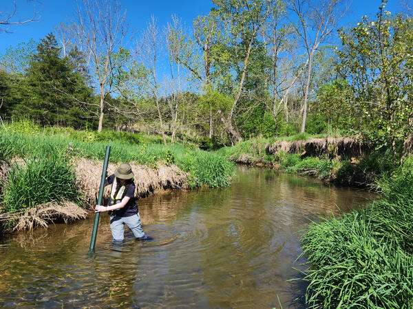
War Branch is a creek in Rockingham County, Virginia. Its 11 square mile watershed includes mostly poultry and beef agricultural activities. This stream is a part of the Chesapeake Bay Small Agricultural Watershed Monitoring Program.
Images
Explore our planet and learn more about our work through photographs and imagery from scientists and support staff.
Filter Total Items: 408

War Branch
War Branch is a creek in Rockingham County, Virginia. Its 11 square mile watershed includes mostly poultry and beef agricultural activities. This stream is a part of the Chesapeake Bay Small Agricultural Watershed Monitoring Program.

Monitoring Station Installation at War Branch
Two hydrologic technicians work on installing a monitoring station at War Branch. NWIS data for this site can be found here.
Two hydrologic technicians work on installing a monitoring station at War Branch. NWIS data for this site can be found here.
Hydrologic Technician Installing a Monitoring Station at War Branch
Hydrologic Technician Installing a Monitoring Station at War BranchHydrologic technician Madison Hagen works on installing a monitoring station at War Branch. NWIS data for this site can be found here.
Hydrologic Technician Installing a Monitoring Station at War Branch
Hydrologic Technician Installing a Monitoring Station at War BranchHydrologic technician Madison Hagen works on installing a monitoring station at War Branch. NWIS data for this site can be found here.

Monitoring Station Installation at War Branch
USGS scientists Hillary Dozier and Jimmy Webber work on installing a monitoring station at War Branch. NWIS data for this site can be found here.
USGS scientists Hillary Dozier and Jimmy Webber work on installing a monitoring station at War Branch. NWIS data for this site can be found here.

War Branch
War Branch is a creek in Rockingham County, Virginia. Its 11 square mile watershed includes mostly poultry and beef agricultural activities. This stream is a part of the Chesapeake Bay Small Agricultural Watershed Monitoring Program.
War Branch is a creek in Rockingham County, Virginia. Its 11 square mile watershed includes mostly poultry and beef agricultural activities. This stream is a part of the Chesapeake Bay Small Agricultural Watershed Monitoring Program.

South Fork Shenandoah River
Aerial photograph of the South Fork of the Shenandoah River near Rileyville, Virginia.
Aerial photograph of the South Fork of the Shenandoah River near Rileyville, Virginia.

Deploying oxygen exchange sensors in the North Fork Shenandoah River
Deploying oxygen exchange sensors in the North Fork Shenandoah RiverA USGS scientist deploys a pair of floating oxygen exchange sensors into the North Fork Shenandoah River. Oxygen exchange rate is an important component in calculating metabolism.

Virginia Coastal Plain Aquifer Geology
Simplified cross-section of the Virginia Coastal Plain showing conceptualized geology of homogeneous and heterogeneous aquifers, confining units, and confining zones.
Simplified cross-section of the Virginia Coastal Plain showing conceptualized geology of homogeneous and heterogeneous aquifers, confining units, and confining zones.

North Fork of the Shenandoah River after a rainstorm
North Fork of the Shenandoah River after a rainstormView from bridge at USGS streamgage (station ID: 01634000) of North Fork of the Shenandoah River after a rainstorm.
Winter 2024 Photo Contest: James Webber, Honorable Mention category
North Fork of the Shenandoah River after a rainstorm
North Fork of the Shenandoah River after a rainstormView from bridge at USGS streamgage (station ID: 01634000) of North Fork of the Shenandoah River after a rainstorm.
Winter 2024 Photo Contest: James Webber, Honorable Mention category

Inside of a USGS Mobile Laboratory Vehicle
The inside of a USGS mobile laboratory vehicle. Water quality samples collected in the field are pre-processed in the mobile lab shortly after collection, then stored on ice before they are transported to and processed at a full water-quality laboratory.
The inside of a USGS mobile laboratory vehicle. Water quality samples collected in the field are pre-processed in the mobile lab shortly after collection, then stored on ice before they are transported to and processed at a full water-quality laboratory.

Monitoring station on the NF Shenandoah River near Strausburg.
Monitoring station on the NF Shenandoah River near Strausburg.The USGS monitoring station 01634000 on the North Fork Shenandoah River near Strausburg.
This photo was taken as a part of the Shenandoah River HABs Project.
Monitoring station on the NF Shenandoah River near Strausburg.
Monitoring station on the NF Shenandoah River near Strausburg.The USGS monitoring station 01634000 on the North Fork Shenandoah River near Strausburg.
This photo was taken as a part of the Shenandoah River HABs Project.

Taking Water Temperature Readings using FLIR
USGS scientist Carly Maas using a forward-looking infrared (FLIR) camera to measure water temperature along the North Fork of the Shenandoah River. Colder temperatures can indicate spring or groundwater inputs to the river.
USGS scientist Carly Maas using a forward-looking infrared (FLIR) camera to measure water temperature along the North Fork of the Shenandoah River. Colder temperatures can indicate spring or groundwater inputs to the river.

North Fork Shenandoah River during a Harmful Algal Bloom Event
North Fork Shenandoah River during a Harmful Algal Bloom EventNorth Fork Shenandoah River during a Harmful Algal Bloom (HAB) event.
This photo was taken near Town Park in Strausburg, and is a part of the Shenandoah River HABs Project.
North Fork Shenandoah River during a Harmful Algal Bloom Event
North Fork Shenandoah River during a Harmful Algal Bloom EventNorth Fork Shenandoah River during a Harmful Algal Bloom (HAB) event.
This photo was taken near Town Park in Strausburg, and is a part of the Shenandoah River HABs Project.

Taking Water Temperature Readings using FLIR
Display screen of a forward-looking infrared (FLIR) camera being used to measure water temperature along the North Fork of the Shenandoah River. Cooler colors indicate lower temperatures, and colder temperatures can indicate spring or groundwater inputs to the river.
Display screen of a forward-looking infrared (FLIR) camera being used to measure water temperature along the North Fork of the Shenandoah River. Cooler colors indicate lower temperatures, and colder temperatures can indicate spring or groundwater inputs to the river.

Taking water samples from the Roanoke River monitoring site at Salem, VA
Taking water samples from the Roanoke River monitoring site at Salem, VATaking water samples from the Roanoke River at Rts 639/760 at Salem, VA - USGS Water Data for the Nation
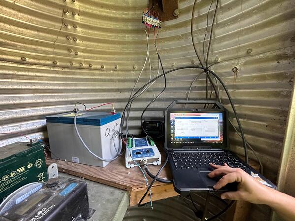
Inside the Mt. Jackson Monitoring Site
Inside the Mt. Jackson monitoring site building.
This photo was taken as a part of the Shenandoah River HABs Project.
Inside the Mt. Jackson monitoring site building.
This photo was taken as a part of the Shenandoah River HABs Project.
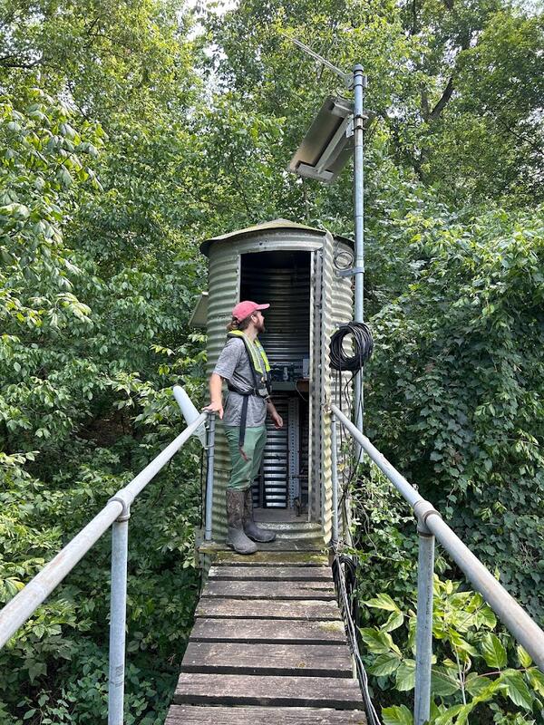
Mt. Jackson Monitoring Station
Mt. Jackson Monitoring Station, located along the North Fork Shenandoah River.
This photo was taken as a part of the Shenandoah River HABs Project.
Mt. Jackson Monitoring Station, located along the North Fork Shenandoah River.
This photo was taken as a part of the Shenandoah River HABs Project.

Deer Rapids during a Harmful Algal Bloom (HAB) Event
Deer Rapids during a Harmful Algal Bloom (HAB) EventDeer Rapids, on the North Fork of the Shenandoah River in Virginia, during a harmful algal bloom (HAB) event. Note how green, filamentous algae coats the riverbed.
Data for this monitoring site can be found at USGS Water Data for the Nation.

Harmful Algal Bloom in the North Fork of the Shenandoah River
Harmful Algal Bloom in the North Fork of the Shenandoah RiverA harmful algal bloom (HAB) event in the Shenandoah River's North Fork. Note the greenish color of the water and the thick mats of stringy algae coating the riverbed.
Harmful Algal Bloom in the North Fork of the Shenandoah River
Harmful Algal Bloom in the North Fork of the Shenandoah RiverA harmful algal bloom (HAB) event in the Shenandoah River's North Fork. Note the greenish color of the water and the thick mats of stringy algae coating the riverbed.

Benthic Algal Mat from a Harmful Algal Bloom
A mat of benthic green and blue-green algae removed from the bottom of the Shenandoah River's North Fork. Collected during a harmful algal bloom.
A mat of benthic green and blue-green algae removed from the bottom of the Shenandoah River's North Fork. Collected during a harmful algal bloom.

North Fork Shenandoah River during a HAB event
A harmful algal bloom (HAB) event in the North Fork Shenandoah River near Strausburg. Algae can be seen floating at the surface in mats, while filamentous algae coats the riverbed below the surface.
A harmful algal bloom (HAB) event in the North Fork Shenandoah River near Strausburg. Algae can be seen floating at the surface in mats, while filamentous algae coats the riverbed below the surface.