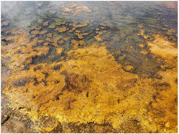
U.S. flag

An official website of the United States government

Images

Volcano Science Center images.

Filter Total Items: 551
The Parting of the Waters, on the Continental Divide south of Yellowstone National Park
The Parting of the Waters

The Parting of the Waters, looking southeast. North Two Ocean Creek splits into Atlantic Creek, flowing to the left in the photo, and Pacific Creek, flowing to the right. The wooden sign indicates that it is 3,488 miles to the Atlantic Ocean and 1,353 miles to the Pacific Ocean.

The Parting of the Waters, looking southeast. North Two Ocean Creek splits into Atlantic Creek, flowing to the left in the photo, and Pacific Creek, flowing to the right. The wooden sign indicates that it is 3,488 miles to the Atlantic Ocean and 1,353 miles to the Pacific Ocean.

Eddy covariance station at Mammoth Mountain, California

Photograph of permanent eddy covariance station installed since 2014 in area of volcanic CO2 emissions on Mammoth Mountain, California. USGS photo by Jennifer Lewicki, August 2019.

Open grassy and rocky meadow under a blue sky. Rocky Peaks that look like towers in the background.
Cirque of the Towers in the Wind River Range, Wyoming

View of the Cirque of the Towers in the Wind River Range, with Pingora Peak in the center. The Bull Lake and Pinedale glaciations carved this valley by steepening and smoothing its granite walls. Image captured while descending from Texas Pass. Image view is toward the southwest. USGS photo by Stanley Mordensky, August 2019.

View of the Cirque of the Towers in the Wind River Range, with Pingora Peak in the center. The Bull Lake and Pinedale glaciations carved this valley by steepening and smoothing its granite walls. Image captured while descending from Texas Pass. Image view is toward the southwest. USGS photo by Stanley Mordensky, August 2019.

Head and mouthparts of the wetsalts tiger beetle

A closeup of the head and mouthparts of the wetsalts tiger beetle, a voracious predator in Yellowstone. Photo by Robert K. D. Peterson, 2019.

Dead lodgepole pine trees with white bases ("bobby socks" trees") near the parking lot of Fountain Paint Pots in the Lower Geyser Basin
"Bobby socks" trees near the parking lot of Fountain Paint Pots in the Lower Geyser Basin, Yellowstone National Park

Dead lodgepole pine trees near the parking lot of Fountain Paint Pots in the Lower Geyser Basin. The trees look as if they are wearing white socks; hence, the name, “bobby socks trees.” The dead trees soak up the silica-rich water, turning the lower portion of the trees white.

Images of snow algae and snow cyanobacteria on snow fields in the Beartooth Mountains of Wyoming and Montana

Images of snow algae and snow cyanobacteria on snow fields in the Beartooth Mountains near the Beartooth Pass Summit (elevation 10,947 ft/3,368 m) on Highway 212. Top left shows a typical pink snow algae bloom on a patch of snow, and top right shows the snow algae bloom scraped off the snow surface with a rock hammer.

Images of snow algae and snow cyanobacteria on snow fields in the Beartooth Mountains near the Beartooth Pass Summit (elevation 10,947 ft/3,368 m) on Highway 212. Top left shows a typical pink snow algae bloom on a patch of snow, and top right shows the snow algae bloom scraped off the snow surface with a rock hammer.

Coring platform on the shore of Goose Lake, Lower Geyser Basin, Yellowstone National Park, in 2018

Coring platform assembled on the shore of Goose Lake, in Lower Geyser Basin, Yellowstone National Park, in 2018. Today, the nearest thermal features are 400 meters (about 1300 feet) away from Goose Lake, but thousands of years ago Goose Lake itself showed indications of being thermally active!. Steam from Midway Geyser Basin can be seen in the distance.

Coring platform assembled on the shore of Goose Lake, in Lower Geyser Basin, Yellowstone National Park, in 2018. Today, the nearest thermal features are 400 meters (about 1300 feet) away from Goose Lake, but thousands of years ago Goose Lake itself showed indications of being thermally active!. Steam from Midway Geyser Basin can be seen in the distance.

Hydrothermal sediment deposits from the Goose Lake (Yellowstone) sediment core

Hydrothermal sediment deposits from the Goose Lake sediment core, Lower Geyser Basin, Yellowstone National Park. The orange sediment (left, scale in cm) consists mostly of fluorite, a common mineral in some hydrothermal deposits, but not usually found in lake sediments.

Hydrothermal sediment deposits from the Goose Lake sediment core, Lower Geyser Basin, Yellowstone National Park. The orange sediment (left, scale in cm) consists mostly of fluorite, a common mineral in some hydrothermal deposits, but not usually found in lake sediments.

Geological time scale showing the geologic eons, eras, periods, epochs, and associated ages in millions of years ago (MYA)

Geologic time scale showing the geologic eons, eras, periods, epochs, and associated ages in millions of years ago (MYA). The time scale also shows major evolutionary and tectonic events in North America.

Vertical motion at GPS station P350, in Idaho, together with nearby snowpack measurements

Vertical motion at GPS station P350, in Idaho, together with nearby snowpack measurements (given as snow water equivalent). The GPS station moves downward as snowpack grows, and moves upward after it melts away. Taken from Knappe, et al., 2018 (https://doi.org/10.1029/2018WR023289).

Vertical deformation and snow depth measured at a GPS site in central Idaho during 2010-2016

Vertical ground motion (red line) measured at GPS site P350, in central Idaho, and snow depth (expressed as Snow Water Equivalent, or SWE; blue line) measured at a nearby SNOTEL site, during 2010-2016. The GPS station moved downward due to the increasing load of the accumulating snow during winter months, and then upward when the snow melted during summer months.

Vertical ground motion (red line) measured at GPS site P350, in central Idaho, and snow depth (expressed as Snow Water Equivalent, or SWE; blue line) measured at a nearby SNOTEL site, during 2010-2016. The GPS station moved downward due to the increasing load of the accumulating snow during winter months, and then upward when the snow melted during summer months.

Map of Norris Geyser Basin showing four subbasins within the overall thermal area
The four subbasins of Norris Geyser Basin, Yellowstone National Park

The four subbasins of Norris Geyser Basin, Yellowstone National Park, as seen on a Google Earth base map.  The curving line to the east of Norris Geyser Basin is the Grand Loop Road (Norris Junction is in the center-right of the image). Figure developed by Bill Keller, Yellowstone National Park. 

The four subbasins of Norris Geyser Basin, Yellowstone National Park, as seen on a Google Earth base map.  The curving line to the east of Norris Geyser Basin is the Grand Loop Road (Norris Junction is in the center-right of the image). Figure developed by Bill Keller, Yellowstone National Park. 

Stream flowing through a grassy landscape, with a vegetated and old basalt lava flow in the distance
Basalts of Warm River and Shotgun Valley, Idaho

The Basalts of Warm River and Shotgun Valley, which erupted about 1.17 million years ago after the formation of Henrys Fork Caldera in southeast Idaho.  Photo by Brandi Lawler, University of Wyoming, August 8, 2018.

The Basalts of Warm River and Shotgun Valley, which erupted about 1.17 million years ago after the formation of Henrys Fork Caldera in southeast Idaho.  Photo by Brandi Lawler, University of Wyoming, August 8, 2018.

A barren plain with some colorful water marking occasional springs amidst white ground. Trees in the distance. Blue sky.
100 Spring Plain in Norris Geyser Basin, Yellowstone National Park

100 Spring Plain in Norris Geyser Basin, Yellowstone National Park.  The area is frequently flooded and impassable. Photo taken by Lauren Harrison in August 2018.

Vertical outcrop of basaltic rock partially covered in moss and dirt with forest in the background
Pinehaven Basalt, Idaho

The Pinehaven Basalt, which erupted in Henrys Fork Caldera, southeast Idaho, about 35,000 years ago.  Photo by Brandi Lawler, University of Wyoming, August 6, 2018.

The Pinehaven Basalt, which erupted in Henrys Fork Caldera, southeast Idaho, about 35,000 years ago.  Photo by Brandi Lawler, University of Wyoming, August 6, 2018.

barren landscape with a hot spring and a line of electrodes stretching into the distance. Forested hills in the background.
Electrical Resistivity Tomography (ERT) measurements near Rosette Spring, Yellowstone National Park

Electrical Resistivity Tomography (ERT) line R3 during setup of ERT and induced polarization measurement near Rosette Spring, Lower Geyser Basin.  Photo by University of Wyoming Geophysics Team, July 17, 2018.

River Styx, Mammoth Hot Springs, Yellowstone National Park

River Styx, Mammoth Hot Springs, Yellowstone National Park. This thermal feature is actually a subterranean hot water creek that likely collects water discharged from Mammoth Hot Spring pools that, after cooling and outflowing from vents, tends to disappear back underground through the porous travertine.

River Styx, Mammoth Hot Springs, Yellowstone National Park. This thermal feature is actually a subterranean hot water creek that likely collects water discharged from Mammoth Hot Spring pools that, after cooling and outflowing from vents, tends to disappear back underground through the porous travertine.

Lower Geyser Basin, with Fountain and Clepsydra Geysers in eruption

View of Lower Geyser Basin, with Fountain and Clepsydra Geysers in eruption, looking south towards Fountain Paint Pots. The vegetation in the photo is indicative of vegetation throughout much of Lower Geyser Basin—open grassland maintained by hot ground with patches of lodgepole pine.

View of Lower Geyser Basin, with Fountain and Clepsydra Geysers in eruption, looking south towards Fountain Paint Pots. The vegetation in the photo is indicative of vegetation throughout much of Lower Geyser Basin—open grassland maintained by hot ground with patches of lodgepole pine.

Color photograph of scientists gathered
Ed Brown (identified by white arrow) pictured with his HVO colleagues during the 2018 Kīlauea eruption

Ed Brown (identified by white arrow, standing behind former USGS HVO Scientist-in-Charge Tina Neal) pictured with his HVO colleagues during the 2018 Kīlauea lower East Rift Zone eruption and summit collapse when HVO staff were temporarily based at the University of Hawaiʻi at Hilo Geology Department following the evacuation of the HVO building in Hawaiʻi Volcano

Ed Brown (identified by white arrow, standing behind former USGS HVO Scientist-in-Charge Tina Neal) pictured with his HVO colleagues during the 2018 Kīlauea lower East Rift Zone eruption and summit collapse when HVO staff were temporarily based at the University of Hawaiʻi at Hilo Geology Department following the evacuation of the HVO building in Hawaiʻi Volcano

Was this page helpful?