



Watersheds and Fluvial Systems Team
Studying watersheds, rivers, and streams
The Watersheds and Fluvial Systems Team at the Washington Water Science Center provides reliable science to understand how watersheds, rivers, and streams function—and how they respond to a changing world. We aim to build partnerships that foster informed decision-making and effective resource management throughout the Pacific Northwest region and across the U.S.
What We Do
We investigate the physical, biological, and climatic processes that shape fluvial systems—from headwater streams to large river networks. Our work spans scales: from fine‑resolution topographic and thermal mapping to regional assessments of sediment transport, water availability, and geomorphic change. By integrating field science, remote sensing, geospatial analysis, and modeling, we bring a powerful interdisciplinary approach to complex watershed challenges.
Our Capabilities
Sediment Dynamics
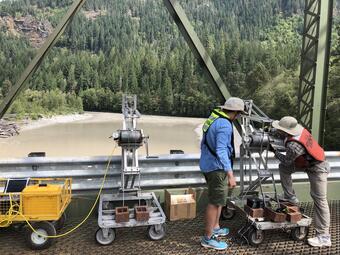
We study how sediment moves through river systems—including suspended sediment, bedload, reservoir sedimentation, and erosion processes—to understand watershed change, inform restoration, and support hazard mitigation.
Watershed Process Modeling
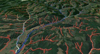
Our team develops and applies models to predict hydrologic and geomorphic behavior, including streamflow permanence and flow statistics, stream temperature dynamics, groundwater/surface-water interactions and sediment transport. These tools help anticipate watershed responses to land‑use change, wildfires, and river restoration.
Geospatial Surveys & Remote Sensing
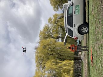
We use geospatial and remote sensing tools to detect landscape change, map physical habitat, quantify sediment sources, and characterize thermal and geomorphic river conditions.
Spatial Analysis & Landscape Change Assessments
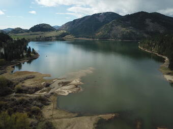
Our team applies advanced GIS, remote sensing, and geospatial statistics to explore watershed connectivity, floodplain processes, channel dynamics, and how watershed structure shapes ecological and hydrologic function.
Meet Our Team
Follow the links to view our team members' staff research profiles.
Krissy Hopkins (Section Supervisor)
- Urban impacts on water quality and quantity
- Green stormwater infrastructure
- Geospatial analysis
- Remote mapping of stream channels and floodplain characteristics
- Fluvial geomorphology
- Sediment sources and transport
- Monitoring channel change
- Topographic and bathymetric surveying
- Photogrammetry
- Fluvial geomorphology
- Sediment data collection
- Outreach and partner engagement
- Continuous and discrete water quality data collection
- Sediment data collection
- Uncrewed Aerial Systems (drones)
- Groundwater-Surface Water interactions
- Land surveying
- Reach scale habitat assessment
- Fluvial geomorphology
- Streamflow permanence
- Low flows and drought
- Sediment monitoring
- Sediment load calculations
- Streamflow monitoring in rivers with mobile beds
- Water temperature dynamics
- Modeling water use and water availability
- Machine learning methods
- Data analysis and synthesis
- Geomorphology
- Watershed hydrology
- Post-wildfire impacts
- Floodplain interactions and carbon dynamics
Science Portfolio
Sediment monitoring
Bed load, lake sediment, sedimentation, historical deposited sediment
- Sediment Transport in Vance Creek
- Sauk River Sediment
- SR 530 Slide
- Quantifying suspended-sediment load and transport characteristics in the Calawah and Upper Bogachiel Rivers, Washington
- Fine sediment infiltration in Chinook spawning gravels in the Sauk River Basin, Washington
- Elwha River Sediment Monitoring
- Sumas River Sediment Load
Geomorphic studies
River movement, channel change, landslides, restoration monitoring
- Hoh geomorphology
- Sauk River Sediment
- SR 530 Slide
- Quantifying suspended-sediment load and transport characteristics in the Calawah and Upper Bogachiel Rivers, Washington
- Fine sediment infiltration in Chinook spawning gravels in the Sauk River Basin, Washington
- Nooksack geomorphology
- Channel Change and Sediment Transport in the Puyallup River Watershed
- Chehalis Watershed Suspended Sediment Monitoring
- Channel change monitoring following the Pilchuck Dam removal
- Coarse sediment delivery and routing in the White River
- Mount Rainier Fluvial Geomorphology and River Sedimentation
Water temperature dynamics
Groundwater-surface water interactions
- Water Temperature Mapping in the Snoqualmie and Skykomish River Basins
- South Fork Nooksack River Basin Groundwater and Surface-water Interactions and Processes
- Water Temperature Dynamics in the Quillayute River Basin
Streamflow permanence
Water availability
- Updated classifications of flow permanence on streams in the Colville National Forest
- State of the Science in Streamflow Modeling in the North Central Region to Address Partner Needs for Water Availability Under Drought Conditions
- Drought preparedness in Mt. Rainier National Park
- Development of a Streamflow Data Catalog and Evaluation of the Vulnerability of Sensitive Fish Species to Climate Change Across the Pacific Northwest
- Probability of Streamflow Permanence (PROSPER)
Wildfire impacts
Post-wildfire sediment runoff
- Bolt Creek Wildfire Sediment Runoff and Water Quality
- Post-wildfire sedimentation and release of metals to Conconully Reservoir, Washington
Other research
- Integrated interdisciplinary studies
- Habitat modeling
- Osoyoos Ice Jam (transboundary waters)
The Watersheds and Fluvial Systems Team at the Washington Water Science Center provides reliable science to understand how watersheds, rivers, and streams function—and how they respond to a changing world. We aim to build partnerships that foster informed decision-making and effective resource management throughout the Pacific Northwest region and across the U.S.
What We Do
We investigate the physical, biological, and climatic processes that shape fluvial systems—from headwater streams to large river networks. Our work spans scales: from fine‑resolution topographic and thermal mapping to regional assessments of sediment transport, water availability, and geomorphic change. By integrating field science, remote sensing, geospatial analysis, and modeling, we bring a powerful interdisciplinary approach to complex watershed challenges.
Our Capabilities
Sediment Dynamics
We study how sediment moves through river systems—including suspended sediment, bedload, reservoir sedimentation, and erosion processes—to understand watershed change, inform restoration, and support hazard mitigation.
Watershed Process Modeling
Our team develops and applies models to predict hydrologic and geomorphic behavior, including streamflow permanence and flow statistics, stream temperature dynamics, groundwater/surface-water interactions and sediment transport. These tools help anticipate watershed responses to land‑use change, wildfires, and river restoration.
Geospatial Surveys & Remote Sensing
We use geospatial and remote sensing tools to detect landscape change, map physical habitat, quantify sediment sources, and characterize thermal and geomorphic river conditions.
Spatial Analysis & Landscape Change Assessments
Our team applies advanced GIS, remote sensing, and geospatial statistics to explore watershed connectivity, floodplain processes, channel dynamics, and how watershed structure shapes ecological and hydrologic function.
Meet Our Team
Follow the links to view our team members' staff research profiles.
Krissy Hopkins (Section Supervisor)
- Urban impacts on water quality and quantity
- Green stormwater infrastructure
- Geospatial analysis
- Remote mapping of stream channels and floodplain characteristics
- Fluvial geomorphology
- Sediment sources and transport
- Monitoring channel change
- Topographic and bathymetric surveying
- Photogrammetry
- Fluvial geomorphology
- Sediment data collection
- Outreach and partner engagement
- Continuous and discrete water quality data collection
- Sediment data collection
- Uncrewed Aerial Systems (drones)
- Groundwater-Surface Water interactions
- Land surveying
- Reach scale habitat assessment
- Fluvial geomorphology
- Streamflow permanence
- Low flows and drought
- Sediment monitoring
- Sediment load calculations
- Streamflow monitoring in rivers with mobile beds
- Water temperature dynamics
- Modeling water use and water availability
- Machine learning methods
- Data analysis and synthesis
- Geomorphology
- Watershed hydrology
- Post-wildfire impacts
- Floodplain interactions and carbon dynamics
Science Portfolio
Sediment monitoring
Bed load, lake sediment, sedimentation, historical deposited sediment
- Sediment Transport in Vance Creek
- Sauk River Sediment
- SR 530 Slide
- Quantifying suspended-sediment load and transport characteristics in the Calawah and Upper Bogachiel Rivers, Washington
- Fine sediment infiltration in Chinook spawning gravels in the Sauk River Basin, Washington
- Elwha River Sediment Monitoring
- Sumas River Sediment Load
Geomorphic studies
River movement, channel change, landslides, restoration monitoring
- Hoh geomorphology
- Sauk River Sediment
- SR 530 Slide
- Quantifying suspended-sediment load and transport characteristics in the Calawah and Upper Bogachiel Rivers, Washington
- Fine sediment infiltration in Chinook spawning gravels in the Sauk River Basin, Washington
- Nooksack geomorphology
- Channel Change and Sediment Transport in the Puyallup River Watershed
- Chehalis Watershed Suspended Sediment Monitoring
- Channel change monitoring following the Pilchuck Dam removal
- Coarse sediment delivery and routing in the White River
- Mount Rainier Fluvial Geomorphology and River Sedimentation
Water temperature dynamics
Groundwater-surface water interactions
- Water Temperature Mapping in the Snoqualmie and Skykomish River Basins
- South Fork Nooksack River Basin Groundwater and Surface-water Interactions and Processes
- Water Temperature Dynamics in the Quillayute River Basin
Streamflow permanence
Water availability
- Updated classifications of flow permanence on streams in the Colville National Forest
- State of the Science in Streamflow Modeling in the North Central Region to Address Partner Needs for Water Availability Under Drought Conditions
- Drought preparedness in Mt. Rainier National Park
- Development of a Streamflow Data Catalog and Evaluation of the Vulnerability of Sensitive Fish Species to Climate Change Across the Pacific Northwest
- Probability of Streamflow Permanence (PROSPER)
Wildfire impacts
Post-wildfire sediment runoff
- Bolt Creek Wildfire Sediment Runoff and Water Quality
- Post-wildfire sedimentation and release of metals to Conconully Reservoir, Washington
Other research
- Integrated interdisciplinary studies
- Habitat modeling
- Osoyoos Ice Jam (transboundary waters)