
Birds
Birds
Filter Total Items: 39
Western U.S. Using Networked Weather Radar and Wildlife Tracking Data
USGS scientists from the Wetland and Aquatic Research Center and the Western Ecological Research Center are collaborating to synthesize data on migratory bird use of Bureau of Land Management lands in the western U.S. to support permitting decisions.
Evaluating Efficacy of Stewardship Actions for Vulnerable Gulf of America Coastal Birds Through Co-Production Between Scientists and Resource Managers
The USGS and partners will survey bird and human activity on beaches in Alabama, Mississippi, and Louisiana to determine breeding bird response to stewardship activities aimed at protecting and recovering bird populations.
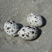
Winter Shorebird Surveys of Federally Protected Bird Species Following Restoration at West Belle Headland and Trinity-East Island, Louisiana
The USGS and the Barataria-Terrebonne National Estuary Program (BTNEP) conducted post-restoration monitoring of Piping Plovers and Red Knots to better understand how birds respond to coastal restoration.

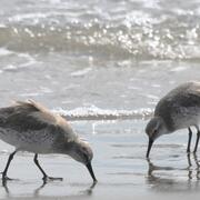
Tracking Non-breeding Habitat Use by Dunlin, Pectoral Sandpipers, and Other Migratory Shorebirds in the Mississippi Delta
USGS researchers and heir partners are capturing and banding birds that use man-made habitats to gather data on species occurrence, abundance, and energetic condition during autumn migration.

Avifauna Surveys of the Northern Main Chandeleur Islands
USGS WARC ecologists are assisting partners in conducting avian surveys on Chandeleur Islands during the pre-restoration monitoring phase to document threatened and endangered species, species richness and diversity, species abundance, and habitat use.

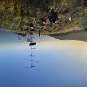
Use of Portable Radar to Monitor Flying Animals in the Offshore Environment
USGS will deploy a small, portable radar aboard a National Oceanic and Atmospheric Administration research vessel to measure the abundance, geographic distribution, and flight altitude of birds migrating across the continental shelf of the northern Gulf.

Monitoring Effects of Barrier Island Restoration on Piping Plovers in Louisiana
The federally threatened piping plover relies on sand-beach habitat year-round for nesting, foraging, and roosting, habitat that is particularly vulnerable to loss and degradation from coastal development, recreation activities, erosion, and sea-level rise.

Beach Compaction and the Impacts of Tilling on Nesting Sea Turtles and Foraging Shorebirds
Researchers are investigating beach compaction, the incubation environment for turtle nests, and shorebird nest abundance at beaches throughout the southeastern United States to better understand the impacts of beach compaction to nesting turtles and foraging seabirds.

Natural Resource Damage and Assessment (NRDA) Program-Louisiana’s Monitoring and Adaptive Management
The USGS is participating in the Louisiana-Trustee Implementation Group Monitoring and Adaptive Management work group to assess the injuries caused by the Deepwater Horizon oil spill and to select the appropriate restoration measures to compensate the public for the injury to coastal and marine resources.

A Multiscale Approach to Understanding Migratory Landbird Habitat Use of Functional Stopover Habitat Types and Management Efforts
USGS scientists are using a spatially-explicit Bayesian network model to predict the difference between energetic value and energetic demand for stopover habitats for migrating landbirds.

Mapping Avian Habitat for the Gulf Coast Joint Venture
The Gulf Coast Joint Venture (GCJV) was established in 1988 as a result of the North American Waterfowl Management Plan, which espouses the restoration of continental waterfowl populations through conservation partnerships in priority habitat regions. Since that time GCJV partners have expanded their mission and purpose to include the provision of habitat to support other priority bird species...

Adapting to Climate Change: Trends and Severe Storm Responses by Migratory Landbirds and Their Habitats
USGS scientists will be analyzing weather surveillance radar observations of birds departing stopover habitats to measure responses to climate change.