
Restoration
Restoration
Filter Total Items: 41
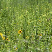
Coastal Prairie Restoration at WARC Supports Ecological Biodiversity and Provides an Opportunity for Education
The USGS Wetland and Aquatic Research Center (WARC) has created a refuge for biodiversity in Lafayette, Louisiana, through the restoration of coastal prairie, a unique and vital ecosystem that has almost vanished within the last 100 years.
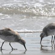
Winter Shorebird Surveys of Federally Protected Bird Species Following Restoration at West Belle Headland and Trinity-East Island, Louisiana
The USGS and the Barataria-Terrebonne National Estuary Program (BTNEP) conducted post-restoration monitoring of Piping Plovers and Red Knots to better understand how birds respond to coastal restoration.

Natural Resource Damage and Assessment (NRDA) Program Monitoring and Adaptive Management
State and Federal agencies, including USGS, are working together to assess the damage caused by the Deepwater Horizon oil spill and to determine appropriate restoration actions to restore natural resources, ecological services, and recreational services injured or lost due to the incident.

Spatial Analysis of Coastal Wetlands Planning, Protection and Restoration Act Projects
As the first federally mandated restoration program, Louisiana enacted the Coastal Wetlands Planning, Protection and Restoration Act (CWPPRA) to address Louisiana’s land loss crisis.

Avifauna Surveys of the Northern Main Chandeleur Islands
USGS WARC ecologists are assisting partners in conducting avian surveys on Chandeleur Islands during the pre-restoration monitoring phase to document threatened and endangered species, species richness and diversity, species abundance, and habitat use.

A Case Study Assessing the Cumulative Effects of Deepwater Horizon Restoration Projects on Barrier Island/Barrier Shoreline Ecosystem Resilience in the North-central Gulf
USGS and partners will assess the potential cumulative effects of restoration projects on the resiliency of barrier islands and barrier shorelines in the north-central Gulf.

Management of Gopher Tortoise (Gopherus polyphemus) Using Coastal Habitats
USGS researchers are conducting research on St. Vincent National Wildlife Refuge and throughout coastal habitat in Northwest Florida to inform future management decisions in the Refuge and contribute to the growing knowledge of the ecology of gopher tortoises using coastal habitats.

Natural Resource Damage and Assessment (NRDA) Program- DOI Monitoring and Adaptive Management Technical Assistance
WARC researchers are providing support to Louisiana Monitoring and Adaptive Management activities.

Monitoring Effects of Barrier Island Restoration on Piping Plovers in Louisiana
The federally threatened piping plover relies on sand-beach habitat year-round for nesting, foraging, and roosting, habitat that is particularly vulnerable to loss and degradation from coastal development, recreation activities, erosion, and sea-level rise.

Sources of Recurring Outbreaks of Lythrum salicaria (Purple Loosestrife) Near the Mouth of the Mississippi River
USGS researchers are examining germination of Purple Loosestrife to determine if the seed bank can reestablish this invasive species in the Mississippi Delta.

Natural Resource Damage and Assessment (NRDA) Program-Louisiana’s Monitoring and Adaptive Management
The USGS is participating in the Louisiana-Trustee Implementation Group Monitoring and Adaptive Management work group to assess the injuries caused by the Deepwater Horizon oil spill and to select the appropriate restoration measures to compensate the public for the injury to coastal and marine resources.

Understanding Avian Habitat Availability and Use After Barrier Island Restoration in Coastal Louisiana
Using ecological and geographical data, WARC researchers and their partners are analyzing avian and benthic sampling on Whiskey Island and Caminda Headland to compare pre- and post-restoration aspects of habitat occupancy, habitat availability, habitat use, and kernal density estimation.