
Distinguished Service Award for USGS Research Geophysicist Carolyn Ruppel, presented on May 8, 2024.
Images
Woods Hole Coastal and Marine Science Center images
Filter Total Items: 1298

Distinguished Service Award - Carolyn Ruppel
Distinguished Service Award for USGS Research Geophysicist Carolyn Ruppel, presented on May 8, 2024.
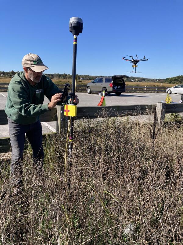
Collecting Shoreline and Volumetric Data
From June through December, WHCMSC scientists are collecting shoreline and volumetric data at a beach in Sandwich, Massachusetts following a 2023 U.S. Army Corps of Engineers beach nourishment. The data will be useful for various purposes. Chris Sherwood is interested in comparing how the different measuring techniques work on different types of vegetation.
From June through December, WHCMSC scientists are collecting shoreline and volumetric data at a beach in Sandwich, Massachusetts following a 2023 U.S. Army Corps of Engineers beach nourishment. The data will be useful for various purposes. Chris Sherwood is interested in comparing how the different measuring techniques work on different types of vegetation.

Ernest F. Hollings ACE Basin National Wildlife Refuge
Ernest F. Hollings ACE Basin National Wildlife RefugeErnest F. Hollings ACE Basin National Wildlife Refuge in South Carolina shown in the pop-out of the U.S. Coastal Wetlands Synthesis Applications geonarrative.
Ernest F. Hollings ACE Basin National Wildlife Refuge
Ernest F. Hollings ACE Basin National Wildlife RefugeErnest F. Hollings ACE Basin National Wildlife Refuge in South Carolina shown in the pop-out of the U.S. Coastal Wetlands Synthesis Applications geonarrative.

Ernest F. Hollings ACE Basin National Wildlife Refuge
Ernest F. Hollings ACE Basin National Wildlife RefugeErnest F. Hollings ACE Basin National Wildlife Refuge in South Carolina shown in the pop-out of the U.S. Coastal Wetlands Synthesis Applications geonarrative.
Ernest F. Hollings ACE Basin National Wildlife Refuge
Ernest F. Hollings ACE Basin National Wildlife RefugeErnest F. Hollings ACE Basin National Wildlife Refuge in South Carolina shown in the pop-out of the U.S. Coastal Wetlands Synthesis Applications geonarrative.

Southeast Region Refuges
The Southeast Region Refuges tab of the U.S. Coastal Wetlands Synthesis Applications geonarrative. A FWS and USGS collaboration.
The Southeast Region Refuges tab of the U.S. Coastal Wetlands Synthesis Applications geonarrative. A FWS and USGS collaboration.

U.S. Coastal Wetland Synthesis Applications geonarrative
U.S. Coastal Wetland Synthesis Applications geonarrativeThe U.S. Coastal Wetlands Synthesis Applications geonarrative. The U.S. Geological Survey (USGS) is assessing the physical condition of coastal wetlands and how they may change in response to storms, sea-level rise, and human activity.

Southeast Region Application
The Southeast Region Refuge tab of the U.S. Coastal Wetlands Synthesis Applications geonarrative, showing the application section. This is a FWS and USGS collaboration.
The Southeast Region Refuge tab of the U.S. Coastal Wetlands Synthesis Applications geonarrative, showing the application section. This is a FWS and USGS collaboration.

Salt marsh with ponding in coastal Connecticut
Salt marsh with ponding in coastal Connecticut, with the sun shining brightly overhead.
Salt marsh with ponding in coastal Connecticut, with the sun shining brightly overhead.

Salt marsh in coastal Massachusetts (Cape Cod)
Salt marsh in coastal Massachusetts (Cape Cod), photographed during estuarine research field work.
Salt marsh in coastal Massachusetts (Cape Cod), photographed during estuarine research field work.

Unveiling Earthquake History at Skilak Lake, Alaska
Unveiling Earthquake History at Skilak Lake, AlaskaR/V Lutris and the OBS are towed to the Upper Skilak Campground boat launch. This is part of a USGS effort, in collaboration with partners from the Woods Hole Oceanographic Institution Ocean Bottom Seismic Instrument Center, to create a record of past earthquakes from Skilak Lake on the Kenai Peninsula of Alaska.

Unveiling Earthquake History at Skilak Lake, Alaska
Unveiling Earthquake History at Skilak Lake, AlaskaSkilak Lake, Alaska. A team of USGS scientists, in collaboration with partners from the Woods Hole Oceanographic Institution Ocean Bottom Seismic Instrument Center, are aiming to create a record of past earthquakes from Skilak Lake on the Kenai Peninsula of Alaska.

Unveiling Earthquake History at Skilak Lake, Alaska
Unveiling Earthquake History at Skilak Lake, AlaskaHannah Brewer (WHOI), Peter Haeussler (USGS), and Tim Kane (WHOI) preparing the OBS float rig at the Upper Skilak Campground parking lot.
Unveiling Earthquake History at Skilak Lake, Alaska
Unveiling Earthquake History at Skilak Lake, AlaskaHannah Brewer (WHOI), Peter Haeussler (USGS), and Tim Kane (WHOI) preparing the OBS float rig at the Upper Skilak Campground parking lot.

Unveiling Earthquake History at Skilak Lake, Alaska
Unveiling Earthquake History at Skilak Lake, AlaskaPeter Haeussler (USGS), Brian Andrews (USGS), Hannah Brewer (WHOI), and Tim Kane (WHOI) prepare to launch the OBS float rig at the Upper Skilak Campground Boat Ramp. R/V Lutris (background) was used to tow the rig to the deployment sites.

Unveiling Earthquake History at Skilak Lake, Alaska
Unveiling Earthquake History at Skilak Lake, AlaskaBrian Andrews (USGS) and Rob Witter (USGS) transfer an electronics and battery box to shore for a land station. This is part of a USGS effort, in collaboration with partners from the Woods Hole Oceanographic Institution Ocean Bottom Seismic Instrument Center, to create a record of past earthquakes from Skilak Lake on the Kenai Peninsula of Alaska.

Unveiling Earthquake History at Skilak Lake, Alaska
Unveiling Earthquake History at Skilak Lake, AlaskaThe float rig supporting the OBS is towed to the deployment site on Skilak Lake with Hannah Brewer (WHOI) on board. This is part of a USGS effort, in collaboration with partners from the Woods Hole Oceanographic Institution Ocean Bottom Seismic Instrument Center, to create a record of past earthquakes from Skilak Lake on the Kenai Peninsula of Alaska.

Unveiling Earthquake History at Skilak Lake, Alaska
Unveiling Earthquake History at Skilak Lake, AlaskaTim Kane (WHOI) on Skilak Lake, Alaska during field work with USGS to create a record of past earthquakes from Skilak Lake on the Kenai Peninsula of Alaska. In May 2024, they deployed two seismographs on the bottom of the lake and eight seismographs on land around the lake. Each instrument will collect data there for about 1 year.

nveiling Earthquake History at Skilak Lake, Alaska
nveiling Earthquake History at Skilak Lake, AlaskaThe R/V Lutris on Skilak Lake, Alaska. A team of USGS scientists, in collaboration with partners from the Woods Hole Oceanographic Institution Ocean Bottom Seismic Instrument Center, are aiming to create a record of past earthquakes from Skilak Lake on the Kenai Peninsula of Alaska.

Unveiling Earthquake History at Skilak Lake, Alaska
Unveiling Earthquake History at Skilak Lake, AlaskaThe OBS is deployed from the float rig on Skilak Lake. This is part of a USGS effort, in collaboration with partners from the Woods Hole Oceanographic Institution Ocean Bottom Seismic Instrument Center, to create a record of past earthquakes from Skilak Lake on the Kenai Peninsula of Alaska.

Unveiling Earthquake History at Skilak Lake, Alaska
Unveiling Earthquake History at Skilak Lake, AlaskaA team of USGS scientists, in collaboration with partners from the Woods Hole Oceanographic Institution Ocean Bottom Seismic Instrument Center, are aiming to create a record of past earthquakes from Skilak Lake on the Kenai Peninsula of Alaska. In May 2024, they deployed two seismographs on the bottom of the lake and eight seismographs on land around the lake.

Unveiling Earthquake History at Skilak Lake, Alaska
Unveiling Earthquake History at Skilak Lake, AlaskaSkilak Lake, Alaska. A team of USGS scientists, in collaboration with partners from the Woods Hole Oceanographic Institution Ocean Bottom Seismic Instrument Center, are aiming to create a record of past earthquakes from Skilak Lake on the Kenai Peninsula of Alaska.

Unveiling Earthquake History at Skilak Lake, Alaska
Unveiling Earthquake History at Skilak Lake, AlaskaHannah Brewer (WHOI) pulling in the R/V Lutris on Skilak Lake, Alaska. This is part of a USGS effort, in collaboration with partners from the Woods Hole Oceanographic Institution Ocean Bottom Seismic Instrument Center, to create a record of past earthquakes from Skilak Lake on the Kenai Peninsula of Alaska.