
Coastal Change Hazards Portal showing maximum wave height and storm surge via the COAWST modeling system during Hurricane Milton.
Images
Woods Hole Coastal and Marine Science Center images
Filter Total Items: 1298
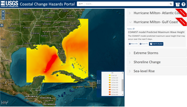
CCH Portal COAWST - Hurricane Milton
Coastal Change Hazards Portal showing maximum wave height and storm surge via the COAWST modeling system during Hurricane Milton.
CCH Portal - Hurricane Milton
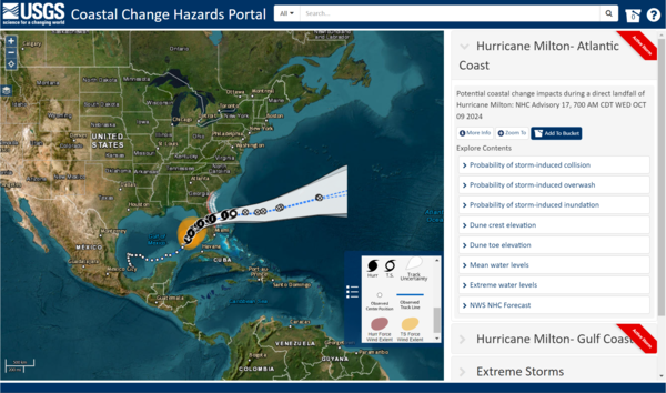
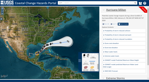
Coastal Change Hazards Portal showing the trajectory of Hurricane Milton and the various data users could explore on the map.
Coastal Change Hazards Portal showing the trajectory of Hurricane Milton and the various data users could explore on the map.
CCH Portal - Hurricane Milton
Coastal Change Hazards Portal showing the trajectory of Hurricane Milton and the various data users could explore on the map.
Coastal Change Hazards Portal showing the trajectory of Hurricane Milton and the various data users could explore on the map.

CoastCam - Hurricane Helene
CoastCam on Madeira Beach in Florida showing coastal conditions during the approach of Hurricane Helene on September 26, 2024.
CoastCam on Madeira Beach in Florida showing coastal conditions during the approach of Hurricane Helene on September 26, 2024.
Companion Guide - CCH Portal page
Coastal Change Hazards Portal page of the Coastal Science Navigator Companion Guide.
Coastal Change Hazards Portal page of the Coastal Science Navigator Companion Guide.
Companion Guide
Screenshots from the Coastal Science Navigator Companion Guide overlaid on top of image of the Army Corps of Engineers Field Research Facility pier near Kitty Hawk, North Carolina.
Screenshots from the Coastal Science Navigator Companion Guide overlaid on top of image of the Army Corps of Engineers Field Research Facility pier near Kitty Hawk, North Carolina.
Icon Page
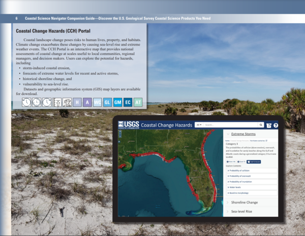
The Coastal Science Navigator Companion Guide introduces you to USGS coastal change hazards-related products—including interactive data maps, downloadable software, geonarratives, and more. It's organized by timescale, highlighting products relevant to the present, past, and future, although many cover multiple timescales.
The Coastal Science Navigator Companion Guide introduces you to USGS coastal change hazards-related products—including interactive data maps, downloadable software, geonarratives, and more. It's organized by timescale, highlighting products relevant to the present, past, and future, although many cover multiple timescales.

Companion Guide - CCL page
The Coastal Change Likelihood Website page of the Coastal Science Navigator Companion Guide.
The Coastal Change Likelihood Website page of the Coastal Science Navigator Companion Guide.

Companion Guide - U.S. Coastal Wetlands Synthesis
The U.S. Coastal Wetlands Synthesis page of the Coastal Science Navigator Companion Guide.
The U.S. Coastal Wetlands Synthesis page of the Coastal Science Navigator Companion Guide.

Chris Sherwood, Athina Lange, and Jin-Si Over look at a monitor hooked up to the CoastCams overlooking Marconi Beach on Cape Cod National Seashore
Chris Sherwood, Athina Lange, and Jin-Si Over look at a monitor hooked up to the CoastCams overlooking Marconi Beach on Cape Cod National SeashoreChris Sherwood, Athina Lange, and Jin-Si Over look at a monitor hooked up to the CoastCams overlooking Marconi Beach on Cape Cod National Seashore. They are aligning the two stationary video cameras so there is a slight overlap in the look angle.

Companion Guide Cover
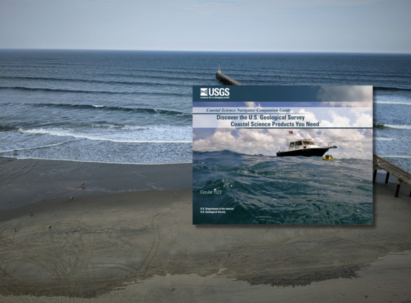
Cover of the Coastal Science Navigator Companion Guide. The guide introduces some of the many coastal change hazards-related products available through the USGS. In it, we showcase the products included in the Coastal Science Navigator’s initial publication in July 2023.
Cover of the Coastal Science Navigator Companion Guide. The guide introduces some of the many coastal change hazards-related products available through the USGS. In it, we showcase the products included in the Coastal Science Navigator’s initial publication in July 2023.

Our Coasts are Valuable
Our coast is valuable and so is the science that protects it.
Our coast is valuable and so is the science that protects it.
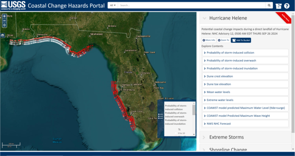
CCH Portal - Hurricane Helene
Coastal Change Hazards Portal showing the probability of storm-induced collision, overwash, and inundation during Hurricane Helene.
Coastal Change Hazards Portal showing the probability of storm-induced collision, overwash, and inundation during Hurricane Helene.
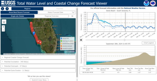
TWL - Hurricane Helene
The Total Water Level and Coastal Change Forecast Viewer reflecting inundation data on the Gulf coast of Florida during Hurricane Helene.
The Total Water Level and Coastal Change Forecast Viewer reflecting inundation data on the Gulf coast of Florida during Hurricane Helene.

Woods Hole Science Stroll 2024
Visitor during the 2024 Woods Hole Science Stroll talking to Marie Bartlett (USGS Geologist) about the foraminifera she viewed in the USGS microscope.
Visitor during the 2024 Woods Hole Science Stroll talking to Marie Bartlett (USGS Geologist) about the foraminifera she viewed in the USGS microscope.

Woods Hole Science Stroll 2024
Seth Ackerman (USGS Geologist) discussing USGS science at the Woods Hole Science Stroll.
Seth Ackerman (USGS Geologist) discussing USGS science at the Woods Hole Science Stroll.

Woods Hole Science Stroll 2024
Zafer Defne (USGS Oceanographer) discussing operational ocean and coastal dynamics forecasts at the Woods Hole Science Stroll.
Zafer Defne (USGS Oceanographer) discussing operational ocean and coastal dynamics forecasts at the Woods Hole Science Stroll.

Woods Hole Science Stroll 2024
Zafer Defne (USGS Oceanographer) discussing operational ocean and coastal dynamics forecasts at the Woods Hole Science Stroll.
Zafer Defne (USGS Oceanographer) discussing operational ocean and coastal dynamics forecasts at the Woods Hole Science Stroll.

Woods Hole Science Stroll 2024
A curious young man, assissted by Marie Bartlett (USGS Geologist), looks through a microscope at the USGS booth at the Woods Hole Science Stroll to view foraminifera, tiny microfossils that live in marine environments.
A curious young man, assissted by Marie Bartlett (USGS Geologist), looks through a microscope at the USGS booth at the Woods Hole Science Stroll to view foraminifera, tiny microfossils that live in marine environments.

Woods Hole Science Stroll 2024
Microscope station at the USGS booth of the Woods Hole Science Stroll, looking at foraminifera, microfossils that live in marine environments.
Microscope station at the USGS booth of the Woods Hole Science Stroll, looking at foraminifera, microfossils that live in marine environments.

Woods Hole Science Stroll 2024
USGS Oceanographer Zafer Defne discussing operational ocean and coastal dynamics forecasts at the Woods Hole Science Stroll.
USGS Oceanographer Zafer Defne discussing operational ocean and coastal dynamics forecasts at the Woods Hole Science Stroll.