
View from USGS streamgage 06175510 near Frazer, MT during the spring of 2023 looking at the Missouri River
Images
Some collected images in Wyoming and Montana.
Filter Total Items: 445

06175510 streamgage near Frazer, MT spring
View from USGS streamgage 06175510 near Frazer, MT during the spring of 2023 looking at the Missouri River
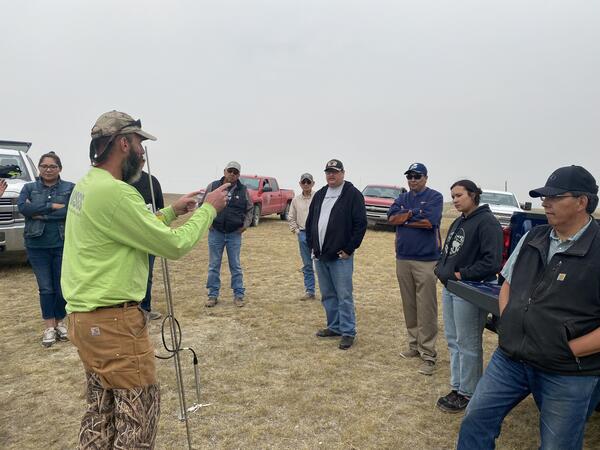
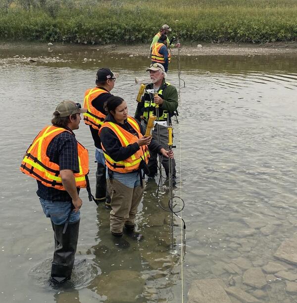
Hydrology Demonstration Day with the Blackfeet Water Department
Hydrology Demonstration Day with the Blackfeet Water DepartmentHydrology Demonstration Day with the Blackfeet Water Department. Attendees included Blackfeet Water Department, Blackfeet Environmental Office, Blackfeet Community College (staff and students), and members of the public.
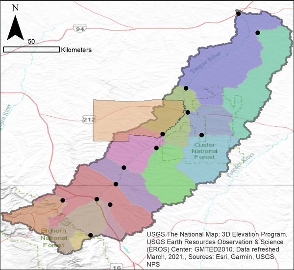
Tongue River Watershed
The Tongue River watershed with USGS gages and contributing areas. This watershed is the focus of future climate modeling for the Tongue River 2100 project.
The Tongue River watershed with USGS gages and contributing areas. This watershed is the focus of future climate modeling for the Tongue River 2100 project.

Tongue River between Tongue River Reservoir and Birney, MT
Tongue River between Tongue River Reservoir and Birney, MTThe Tongue River flowing past red canyon walls and green fields between Tongue River Reservoir and Birney, Montana.
Tongue River between Tongue River Reservoir and Birney, MT
Tongue River between Tongue River Reservoir and Birney, MTThe Tongue River flowing past red canyon walls and green fields between Tongue River Reservoir and Birney, Montana.

Horses inspecting the new well installation on the Blackfeet Reservation
Horses inspecting the new well installation on the Blackfeet ReservationHorses inspecting the new well installation on the Blackfeet Reservation. Click here to learn more about the Hydrologic Assessment of the Blackfeet Reservation, Montana.

Dogs inspecting the new well installation on the Blackfeet Reservation
Dogs inspecting the new well installation on the Blackfeet ReservationDogs inspecting the new well installation on the Blackfeet Reservation. Click here to learn more about the Hydrologic Assessment of the Blackfeet Reservation, Montana.

Blackfeet Water Department cooperator showcases new monitoring well
Blackfeet Water Department cooperator showcases new monitoring wellBlackfeet Water Department cooperator showcases new monitoring well. Click here to learn more about the Hydrologic Assessment of the Blackfeet Reservation, Montana.
Blackfeet Water Department cooperator showcases new monitoring well
Blackfeet Water Department cooperator showcases new monitoring wellBlackfeet Water Department cooperator showcases new monitoring well. Click here to learn more about the Hydrologic Assessment of the Blackfeet Reservation, Montana.

Well Installation on the Blackfeet Reservation
Well installation on the Blackfeet Reservation. Click here to learn more about the project.
Well installation on the Blackfeet Reservation. Click here to learn more about the project.

Well Installation on the Blackfeet Reservation
Well installation on the Blackfeet Reservation. Click here to learn more about the project.
Well installation on the Blackfeet Reservation. Click here to learn more about the project.

Surveying Sunlight Creek near Painter, WY
Surveying Sunlight Creek near Painter, Wyoming. USGS gage 06206500 is no longer operating but floodwaters were estimated using high water marks found at the site.
Surveying Sunlight Creek near Painter, Wyoming. USGS gage 06206500 is no longer operating but floodwaters were estimated using high water marks found at the site.

High water mark from the Stillwater River near Nye, MT
High water mark from the Stillwater River near Nye, MTFloodwaters left a clear high water mark on a public restroom next to the Stillwater River near Nye, MT. The area was flagged to perform a slope area discharge measurement.
High water mark from the Stillwater River near Nye, MT
High water mark from the Stillwater River near Nye, MTFloodwaters left a clear high water mark on a public restroom next to the Stillwater River near Nye, MT. The area was flagged to perform a slope area discharge measurement.

High water mark from the Stillwater River near Nye, MT
High water mark from the Stillwater River near Nye, MTFloodwaters left a clear high water mark on a public restroom next to the Stillwater River near Nye, MT. The area was flagged to perform a slope area discharge measurement.
High water mark from the Stillwater River near Nye, MT
High water mark from the Stillwater River near Nye, MTFloodwaters left a clear high water mark on a public restroom next to the Stillwater River near Nye, MT. The area was flagged to perform a slope area discharge measurement.

High water mark from the Stillwater River near Nye, MT
High water mark from the Stillwater River near Nye, MTFloodwaters left a clear high water mark on a public restroom next to the Stillwater River near Nye, MT. The area was flagged to perform a slope area discharge measurement.
High water mark from the Stillwater River near Nye, MT
High water mark from the Stillwater River near Nye, MTFloodwaters left a clear high water mark on a public restroom next to the Stillwater River near Nye, MT. The area was flagged to perform a slope area discharge measurement.

High water mark from the Stillwater River near Nye, MT
High water mark from the Stillwater River near Nye, MTFloodwaters left a clear high water mark on a public restroom next to the Stillwater River near Nye, MT. The area was flagged to perform a slope area discharge measurement.
High water mark from the Stillwater River near Nye, MT
High water mark from the Stillwater River near Nye, MTFloodwaters left a clear high water mark on a public restroom next to the Stillwater River near Nye, MT. The area was flagged to perform a slope area discharge measurement.

Flood waters of the Yellowstone River at Billings, MT
Flood waters of the Yellowstone River at Billings, MTFlood waters of the Yellowstone River at Billings, MT, streamgage 06214500
Flood waters of the Yellowstone River at Billings, MT
Flood waters of the Yellowstone River at Billings, MTFlood waters of the Yellowstone River at Billings, MT, streamgage 06214500

06191500 Yellowstone River at Corwin Springs MT, discharge measurement
06191500 Yellowstone River at Corwin Springs MT, discharge measurementStreamgage 06191500, Yellowstone River at Corwin Springs, MT discharge measurement
06191500 Yellowstone River at Corwin Springs MT, discharge measurement
06191500 Yellowstone River at Corwin Springs MT, discharge measurementStreamgage 06191500, Yellowstone River at Corwin Springs, MT discharge measurement

Streamflow measurement at 06192500 Yellowstone River near Livingston, MT
Streamflow measurement at 06192500 Yellowstone River near Livingston, MTStreamflow measurement at 06192500 Yellowstone River near Livingston, Montana during 2022 flooding
Streamflow measurement at 06192500 Yellowstone River near Livingston, MT
Streamflow measurement at 06192500 Yellowstone River near Livingston, MTStreamflow measurement at 06192500 Yellowstone River near Livingston, Montana during 2022 flooding

Sampling Water Quality on the Yellowstone River near Livingston, MT
Sampling Water Quality on the Yellowstone River near Livingston, MTSampling Water Quality on the Yellowstone River near Livingston, Montana. Click here to access data collected at this gage.
Sampling Water Quality on the Yellowstone River near Livingston, MT
Sampling Water Quality on the Yellowstone River near Livingston, MTSampling Water Quality on the Yellowstone River near Livingston, Montana. Click here to access data collected at this gage.

Sampling Water Quality on the Yellowstone River near Livingston, MT
Sampling Water Quality on the Yellowstone River near Livingston, MTSampling Water Quality on the Yellowstone River near Livingston, Montana. Click here to access data collected at this gage.
Sampling Water Quality on the Yellowstone River near Livingston, MT
Sampling Water Quality on the Yellowstone River near Livingston, MTSampling Water Quality on the Yellowstone River near Livingston, Montana. Click here to access data collected at this gage.

Sampling Water Quality on the Yellowstone River near Livingston, MT
Sampling Water Quality on the Yellowstone River near Livingston, MTSampling Water Quality on the Yellowstone River near Livingston, Montana. Click here to access data collected at this gage.
Sampling Water Quality on the Yellowstone River near Livingston, MT
Sampling Water Quality on the Yellowstone River near Livingston, MTSampling Water Quality on the Yellowstone River near Livingston, Montana. Click here to access data collected at this gage.