U.S. flag

An official website of the United States government

Images

Some collected images in Wyoming and Montana.

Filter Total Items: 445
View of streamgage sonde during spring at Birch Creek at Robare, Montana
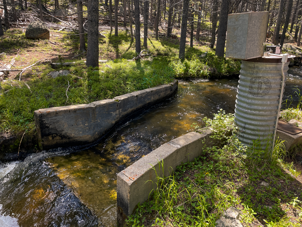
Streamgage sonde at Birch Creek at Robare, Montana

Streamgage sonde at 06097000 Birch Creek at Robare, Montana during spring time. This streamgage is part of the Hydrologic Assessment of the Blackfeet Reservation, Montana project. 

USGS streamgage 06177000 near Wolf Point, MT during sunset

View from USGS 06177000 streamgage near Wolf Point, MT looking at the Missouri River at sunset 

View from bridge at streamgage box overlooking Birch Creek during winter
Birch Creek at Bullhead Bridge, Montana

Streamgage 06098120 Birch Creek at Bullhead Bridge near Valier, Montana is a streamgage installed as part of the Hydrologic Assessment of the Blackfeet Reservation, Montana project. 

Streamgage 06098120 Birch Creek at Bullhead Bridge near Valier, Montana is a streamgage installed as part of the Hydrologic Assessment of the Blackfeet Reservation, Montana project. 

American Fork Fire Burn area with view of mountains in the background
American Fork Fire
American Fork Fire
American Fork Fire

 American Fork Fire (2021) and Woods Creek (2021) burn severity, area is part of a Water Quality Post Wildfire study 

 American Fork Fire (2021) and Woods Creek (2021) burn severity, area is part of a Water Quality Post Wildfire study 

Service station in wildfire burn area
Mule Creek Met Station (USGS 463507111154201) in the Camas Creek headwaters.

Mule Creek Met Station (USGS 463507111154201) in the Camas Creek headwaters. Study area for Wildfires and Water Quality in Montana

USGS Streamgage 06174500 at Nashua, MT Fall 2023 looking downstream at vibrant fall colored trees
USGS Streamgage 06174500 at Nashua, MT Fall 2023

USGS Streamgage 06174500 at Nashua, MT Fall 2023 looking downstream at vibrant fall-colored trees from the streamgage. 

insert caption here
Koocanusa Watersheds Map

insert caption here insert caption here insert caption here insert caption here insert caption hereinsert caption here

insert caption here insert caption here insert caption here insert caption here insert caption hereinsert caption here

Multiple people stand in circle in grassy area, hills in background, cloudy skies
WLCI Tour at Littlefield Creek

USGS scientist Jason Alexander, a fluvial geomorphologist with the Wyoming Montana Water Science Center, explains how he used sediment traps to evaluate sediment deposition in Littlefield Creek (Carbon County, Wyoming). Photo by Patrick Anderson (USGS).

USGS scientist Jason Alexander, a fluvial geomorphologist with the Wyoming Montana Water Science Center, explains how he used sediment traps to evaluate sediment deposition in Littlefield Creek (Carbon County, Wyoming). Photo by Patrick Anderson (USGS).

photo of creek flowing through mixed grass and shrubland. Small hill and cloudy sky in background.
MuddyCreekChannel.jpg

Vegetation growth is assisting the Muddy Creek channel in becoming deeper and narrower (Carbon County, Wyoming).  Photo by Patrick Anderson (USGS)

Vegetation growth is assisting the Muddy Creek channel in becoming deeper and narrower (Carbon County, Wyoming).  Photo by Patrick Anderson (USGS)

Small mounds of mud in grasses lining a creek.
Burrowing rodents leave casts along Littlefield Creek

Small rodents disturb surface soil on banks which contribute to fine sediments in the upper reaches of Littlefield Creek (Carbon County, Wyoming). Photo by Patrick Anderson (USGS).

Small rodents disturb surface soil on banks which contribute to fine sediments in the upper reaches of Littlefield Creek (Carbon County, Wyoming). Photo by Patrick Anderson (USGS).

Components of Wyoming StreamStats

Wyoming StreamStats includes data on land use, land cover, soils, climate, elevation, and streamflow statistics and prediction equations.

Wyoming StreamStats includes data on land use, land cover, soils, climate, elevation, and streamflow statistics and prediction equations.

View of an older diversion dam on the Tongue River in Wyoming during summer
Old diversion dam Tongue River

View of an older diversion dam on the Tongue River during a site visit for the Tongue River 2100 project  

View of an older diversion dam on the Tongue River during a site visit for the Tongue River 2100 project  

Diversion monitoring equipment in the Big Horn Mountains, Wup,omg
Diversion monitoring equipment

Diversion monitoring equipment in the Bighorn Mountains, Wyoming during a site visit for Tongue River 2100 project. 

Diversion monitoring equipment in the Bighorn Mountains, Wyoming during a site visit for Tongue River 2100 project. 

View of Tong River with hills in the background
Tongue River
Tongue River
Tongue River

Tongue River during a site visit for Tongue River 2100 project supporting research on future hydrologic patterns and modeling. 

Tongue River during a site visit for Tongue River 2100 project supporting research on future hydrologic patterns and modeling. 

View of the Tongue River during a summer site visit with hills in the background
Tongue River
Tongue River
Tongue River

View of the Tongue River during a summer site visit for the Tongue River 2100 project 

View of the Tongue River during a summer site visit for the Tongue River 2100 project 

View of tongue river during summer with pines and willows surrounding the river
Tongue River 2100 project site visit

Site visit to Tongue River in Wyoming for Tongue River 2100: Future Streamflow Estimates for Tongue River to Enable Northern Cheyenne Data Driven Water Management and Planning project.

Site visit to Tongue River in Wyoming for Tongue River 2100: Future Streamflow Estimates for Tongue River to Enable Northern Cheyenne Data Driven Water Management and Planning project.

Project Area Map
Project Area Map
Project Area Map
Project Area Map

Watershed boundaries for Shields River ab Smith Cr, nr Wilsall, MT (USGS 06192980) and Camas Creek nr Mouth nr White Sulphur Springs, MT (USGS 06076590). American Fork Fire (2021) and Woods Creek (2021) burn severity and perimeters also pictured.

Watershed boundaries for Shields River ab Smith Cr, nr Wilsall, MT (USGS 06192980) and Camas Creek nr Mouth nr White Sulphur Springs, MT (USGS 06076590). American Fork Fire (2021) and Woods Creek (2021) burn severity and perimeters also pictured.

Was this page helpful?