
USGS hydrologic technician measuring streamflow in the Merced River, near Happy Isles stream gage in Yosemite Valley.
Images
Images
Filter Total Items: 9448

Measuring Streamflow
USGS hydrologic technician measuring streamflow in the Merced River, near Happy Isles stream gage in Yosemite Valley.

Happy Isles Gage House
USGS Happy Isles streamgage house with explanatory exhibits on the Merced River, Yosemite Valley.
USGS Happy Isles streamgage house with explanatory exhibits on the Merced River, Yosemite Valley.

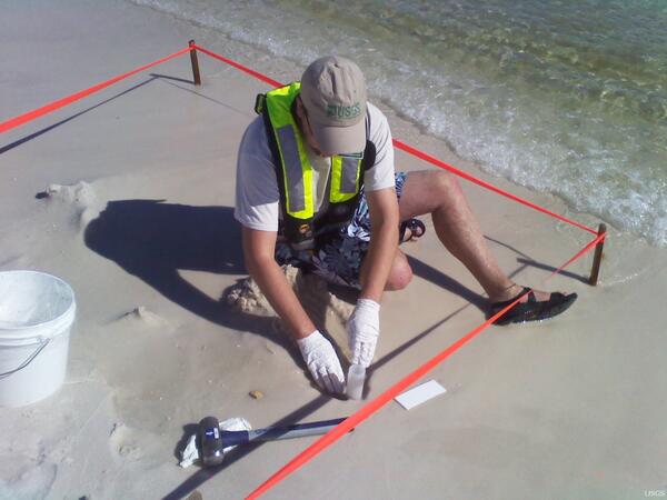
USGS Sampling Site at Henderson Beach State Park
U.S.

Spring near Leon Creek in the Trinity aquifer outcrop
Spring near Leon Creek in the Trinity aquifer outcropSpring (113) near Leon Creek in the Trinity aquifer outcrop, northern Bexar County, Texas. Photograph taken on Tuesday, October 5, 2010.
Data Series 750
Spring near Leon Creek in the Trinity aquifer outcrop
Spring near Leon Creek in the Trinity aquifer outcropSpring (113) near Leon Creek in the Trinity aquifer outcrop, northern Bexar County, Texas. Photograph taken on Tuesday, October 5, 2010.
Data Series 750

Spring near headwaters of Leon Creek, Trinity aquifer, Data Series 750
Spring near headwaters of Leon Creek, Trinity aquifer, Data Series 750Spring (104) near the headwaters of Leon Creek in the Trinity aquifer outcrop, northern Bexar County, Texas. Photograph taken on Tuesday, October 5, 2010.
Spring near headwaters of Leon Creek, Trinity aquifer, Data Series 750
Spring near headwaters of Leon Creek, Trinity aquifer, Data Series 750Spring (104) near the headwaters of Leon Creek in the Trinity aquifer outcrop, northern Bexar County, Texas. Photograph taken on Tuesday, October 5, 2010.

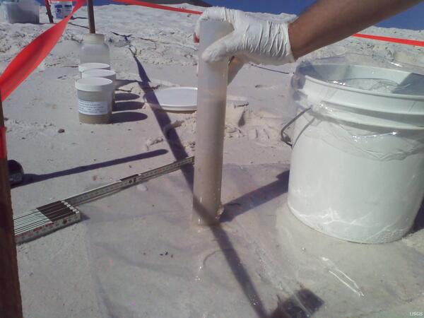
USGS Sediment Sampling at Henderson Beach State Park
USGS Sediment Sampling at Henderson Beach State ParkU.S.
USGS Collects Sample at Gulf Island
U.S.
USGS Collects Sediment Core at Gulf Island
U.S.

Breakout Near Kalapana
A new breakout started yesterday afternoon (9/30) near Kalapana. By this morning, the flow had nearly stopped, its front (shown here) barely creeping forward through grass and sparse forest.
A new breakout started yesterday afternoon (9/30) near Kalapana. By this morning, the flow had nearly stopped, its front (shown here) barely creeping forward through grass and sparse forest.

Breakout Near Kalapana
The breakout was from the side of the lava tube feeding the Puhi-o-Kalaikini ocean entry a few hundred meters (yards) upslope from where the tube crosses Highway 130. The photo is taken from the crest of the tube, which forms a low ridge snaking through the flow field in this area.
The breakout was from the side of the lava tube feeding the Puhi-o-Kalaikini ocean entry a few hundred meters (yards) upslope from where the tube crosses Highway 130. The photo is taken from the crest of the tube, which forms a low ridge snaking through the flow field in this area.

Whooping Crane Chick
This adolescent chick, hatched and raised at the USGS Patuxent Wildlife Research Center, is one of ten whooping cranes being released in Louisiana in February 2011. It is a milestone for the state and for the birds, which have not lived in the state since the 1950s.
This adolescent chick, hatched and raised at the USGS Patuxent Wildlife Research Center, is one of ten whooping cranes being released in Louisiana in February 2011. It is a milestone for the state and for the birds, which have not lived in the state since the 1950s.

Red River of the North at Grand Forks
Red River of the North at Grand Forks on September 27, 2010.
Red River of the North at Grand Forks on September 27, 2010.

Scientists study Fourmile Creek Burn Area
Older debris-flow sediment deposits in lower Emerson Gulch, burned by the Fourmile Canyon wildfire; view is upstream.
Older debris-flow sediment deposits in lower Emerson Gulch, burned by the Fourmile Canyon wildfire; view is upstream.

Scientists study Fourmile Creek Burn Area
Upper Emerson Gulch, burned by the Fourmile Canyon wildfire; view is downstream.
Upper Emerson Gulch, burned by the Fourmile Canyon wildfire; view is downstream.

Rocky Mountain National Park
Scenic shots of Rocky Mountain National Park stream.
Scenic shots of Rocky Mountain National Park stream.

Rocky Mountain National Park
Scenic shots of Rocky Mountain National Park, lake on highway 34 near the Southern park entrance.
Scenic shots of Rocky Mountain National Park, lake on highway 34 near the Southern park entrance.

Rocky Mountain National Park
Scenic shots of Rocky Mountain National Park, Grand Lake near the South entrance to the park.
Scenic shots of Rocky Mountain National Park, Grand Lake near the South entrance to the park.

Rocky Mountain National Park
Scenic shots of Rocky Mountain National Park, near Bear Lake.
Scenic shots of Rocky Mountain National Park, near Bear Lake.

Rocky Mountain National Park
Scenic shots of Rocky Mountain National Park.
Scenic shots of Rocky Mountain National Park.

Rocky Mountain National Park
Scenic shots of Rocky Mountain National Park, Mountain Pine Beetle damage to pine forest.
Scenic shots of Rocky Mountain National Park, Mountain Pine Beetle damage to pine forest.

Rocky Mountain National Park
Scenic shots of Rocky Mountain National Park, South park entrance sign.
Scenic shots of Rocky Mountain National Park, South park entrance sign.