
Storm sampling in action.
Images
Images
Filter Total Items: 9447

Storm Sampling on the Clinch River

Fisherman on the Mekong River, Lao PDR
Fisherman on the Mekong River, Lao PDR
Fisherman on the Mekong River, Lao PDR

Artisanal Fishing in Lao PDR
Artisanal Fishing in Lao PDR
Artisanal Fishing in Lao PDR

Satellite image of resuspended volcanic ash cloud over Kodiak Island, Alaska
Satellite image of resuspended volcanic ash cloud over Kodiak Island, AlaskaMODIS Aqua 1 km true color satellite image showing resuspended volcanic ash cloud (arrow) generated from high winds scouring exposed ash on the Pacific side of the Katmai volcanic range. The cloud stretches across the Shelikof Straight and western Kodiak Island. Image ID 2010333 taken November 29, 2010. Courtesy NASA.

Annotated Satellite Image of southern Alaska Showing Anchorage and Kodiak Island
Annotated Satellite Image of southern Alaska Showing Anchorage and Kodiak IslandThis MODIS Aqua 1-km-resolution, true-color satellite image shows a resuspended ash cloud generated from high winds scouring the dry, unvegetated deposits in the Valley of Ten Thousand Smokes. The cloud stretches across Shelikof Strait to western Kodiak Island.
Location: south-central Alaska, from Kodiak to Anchorage

Receding Shoreline
Receding shoreline on the east side of the Salton Sea, California.
Receding shoreline on the east side of the Salton Sea, California.

Honolulu Geomagnetic Observatory
Electronics building at Ewa Beach, HI magnetic observatory.
Electronics building at Ewa Beach, HI magnetic observatory.

Geologist On The Western Rim of Pu'u 'O 'o
Geologist changing the data card in a time-lapse camera on the western rim of Pu'u 'O 'o. The lack of trade winds allowed for a clear view into the crater.
Geologist changing the data card in a time-lapse camera on the western rim of Pu'u 'O 'o. The lack of trade winds allowed for a clear view into the crater.

Puhi-o-Kalaikini Ocean Entry
A similar wide shot of the flow field, incorporating more of the coastline west of the ocean entry. Hilina Pali is the cliff face in the background. Small lava channels enter the ocean along a section of the Puhi-o-Kalaikini lava delta.
A similar wide shot of the flow field, incorporating more of the coastline west of the ocean entry. Hilina Pali is the cliff face in the background. Small lava channels enter the ocean along a section of the Puhi-o-Kalaikini lava delta.

Puhi-o-Kalaikini Ocean Entry Thermal Image
This overlay of a photograph, and a thermal image of the same area, highlights several active breakouts on the coastal plain. Comparing today's image to the composite taken on Oct 28, the breakouts are new, but most of the other features are unchanged.
This overlay of a photograph, and a thermal image of the same area, highlights several active breakouts on the coastal plain. Comparing today's image to the composite taken on Oct 28, the breakouts are new, but most of the other features are unchanged.

Hoover Dam and Lake Mead
View of Hoover Dam and Lake Mead from the Mike O'Callaghan–Pat Tillman Memorial Bridge (Colorado River Bridge).
View of Hoover Dam and Lake Mead from the Mike O'Callaghan–Pat Tillman Memorial Bridge (Colorado River Bridge).

Dam with overflow pipe discharging water from spring
Dam with overflow pipe discharging water from springDam with overflow pipe discharging water from spring (109) near Lee Creek in the Trinity aquifer outcrop, northern Bexar County, Texas. Photograph taken on Monday, November 15, 2010.
Data Series 750

Invasive brown treesnake
Brown treesnakes were a major contributor to the loss of nine of 11 native forest birds on Guam.
Brown treesnakes were a major contributor to the loss of nine of 11 native forest birds on Guam.

A Bleached Coral Next to an Unbleached Coral
A bleached colony of Diploria labyrinthiformis next to an unbleached colony of Colpophyllia natans.
A bleached colony of Diploria labyrinthiformis next to an unbleached colony of Colpophyllia natans.

View Into Halema'uma'u Overlook Vent
Looking into the Halema'uma'u Overlook vent during a lava high stand. In the lower half of the vent, several glowing cracks in the crusted lava surface can be seen through the diffuse fume. The remaining portion of the Halema'uma'u Overlook fence is at the bottom of the photograph.
Looking into the Halema'uma'u Overlook vent during a lava high stand. In the lower half of the vent, several glowing cracks in the crusted lava surface can be seen through the diffuse fume. The remaining portion of the Halema'uma'u Overlook fence is at the bottom of the photograph.

Lava Channels of Puhi-o-Kalaikini Lava Delta
Small lava channels enter the ocean along a section of the Puhi-o-Kalaikini lava delta.
Small lava channels enter the ocean along a section of the Puhi-o-Kalaikini lava delta.

Monitoring Gas Emissions from Kilauea Volcano
Sulfur dioxide gas emissions from the crater of Pu‘u ‘Ō ‘ō on Kīlauea’s east rift zone and the vent within Halema‘uma‘u Crater at Kīlauea’s summit create volcanic pollution that affects the air quality of downwind communities. Here, a USGS Hawaiian Volcano Observatory gas geochemist measures Pu‘u ‘Ō‘ō gas emissions using an instrument that detects ga
Sulfur dioxide gas emissions from the crater of Pu‘u ‘Ō ‘ō on Kīlauea’s east rift zone and the vent within Halema‘uma‘u Crater at Kīlauea’s summit create volcanic pollution that affects the air quality of downwind communities. Here, a USGS Hawaiian Volcano Observatory gas geochemist measures Pu‘u ‘Ō‘ō gas emissions using an instrument that detects ga

An Aerial View of Pu'u 'O 'o
An aerial view of Pu'u 'O 'o, looking toward the southwest. Although the inside of the crater is shrouded in fume, a distinct plume can still be seen coming from the east wall. This vent has once again become the dominant heat source in Pu'u 'O 'o since the cessation of flows in the crater several weeks ago.
An aerial view of Pu'u 'O 'o, looking toward the southwest. Although the inside of the crater is shrouded in fume, a distinct plume can still be seen coming from the east wall. This vent has once again become the dominant heat source in Pu'u 'O 'o since the cessation of flows in the crater several weeks ago.

Open-water
Open-water conditions at weir. Flow is 15.9 cubic feet per second.
Open-water conditions at weir. Flow is 15.9 cubic feet per second.
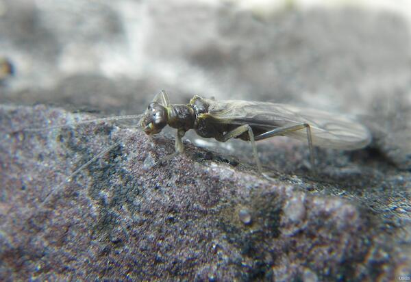
Meltwater Stonefly (Lednia tumana)
Loss of glaciers and snowpack due to climate warming in alpine regions is putting pressure on a rare aquatic insect, the meltwater stonefly, according to a U.S. Geological Survey study.
Loss of glaciers and snowpack due to climate warming in alpine regions is putting pressure on a rare aquatic insect, the meltwater stonefly, according to a U.S. Geological Survey study.

Celebrating the First USGS Streamgage
The first USGS streamgage, at Embudo, New Mexico, just turned 125 years old.
The first USGS streamgage, at Embudo, New Mexico, just turned 125 years old.