
North Dakota Discovery Farms Dazey waterway site 3 being rebuilt after 2009 Spring runoff.
Images
Images
Filter Total Items: 9448
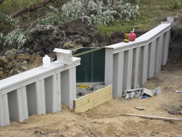
Dazey Waterway Construction
North Dakota Discovery Farms Dazey waterway site 3 being rebuilt after 2009 Spring runoff.

Hawaiian Hoary Bat
A Hawaiian Hoary fits in the palm of one's hand.
A Hawaiian Hoary fits in the palm of one's hand.
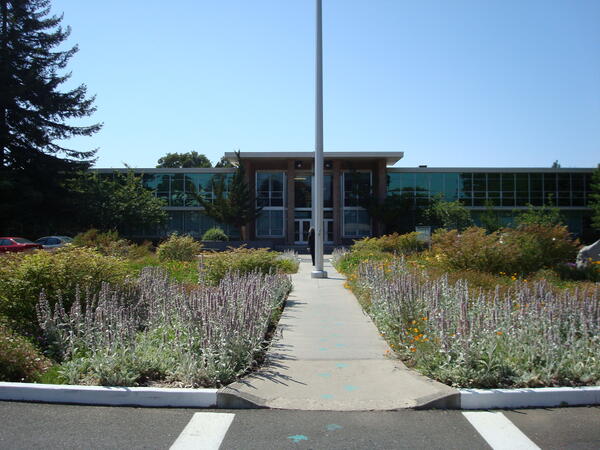
USGS Menlo Park Office
Building 3 at the USGS location in Menlo Park, CA, looking across the flagpole circle.
Building 3 at the USGS location in Menlo Park, CA, looking across the flagpole circle.

Water on the Prairie
The upper Sheyenne River, above Harvey, North Dakota, meandering through a pasture.
The upper Sheyenne River, above Harvey, North Dakota, meandering through a pasture.

Eft Stage of a Red-Spotted Newt
The eft stage of a red-spotted newt in Walker County, Georgia (Crockford-Pigeon Mountain Wildlife Management Area)
The eft stage of a red-spotted newt in Walker County, Georgia (Crockford-Pigeon Mountain Wildlife Management Area)

Eft Stage of a Red-Spotted Newt
The eft stage of a red-spotted newt in Walker County, Georgia (Crockford-Pigeon Mountain Wildlife Management Area)
The eft stage of a red-spotted newt in Walker County, Georgia (Crockford-Pigeon Mountain Wildlife Management Area)

Gray treefrog blending in to tree bark
Tamarac National Wildlife Refuge, Hyla versicolor - Gray Treefrog, ARMI photo by Mark Roth. UMESC
Tamarac National Wildlife Refuge, Hyla versicolor - Gray Treefrog, ARMI photo by Mark Roth. UMESC

Sampling at Ice Out
Rob Spencer, UCDavis Professor and USGS Volunteer collecting a water quality sample with a custom-made "pole sampler" during ice out.
Rob Spencer, UCDavis Professor and USGS Volunteer collecting a water quality sample with a custom-made "pole sampler" during ice out.
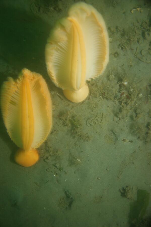
Puget Sound Seafloor
This photograph is of the Puget Sound seafloor and shows a sandy area with partial hydroid and algae cover occupied by two sea pens. This image was collected as part of USGS efforts to help with rockfish recovery in the Puget Sound. Scientists are mapping their ecosystem and habitat to understand population distribution
This photograph is of the Puget Sound seafloor and shows a sandy area with partial hydroid and algae cover occupied by two sea pens. This image was collected as part of USGS efforts to help with rockfish recovery in the Puget Sound. Scientists are mapping their ecosystem and habitat to understand population distribution
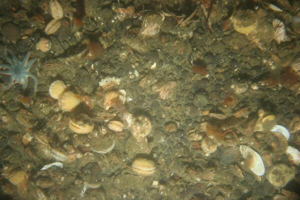
Puget Sound Seafloor
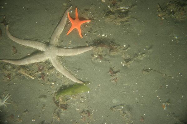
This photograph is of the Puget Sound seafloor and shows a gravel area with numerous scallops, a sea star, several small anemones and colonial hydroids.This image was collected as part of USGS efforts to help with rockfish recovery in the Puget Sound. Scientists are mapping their ecosystem and habitat to understand population distribution
This photograph is of the Puget Sound seafloor and shows a gravel area with numerous scallops, a sea star, several small anemones and colonial hydroids.This image was collected as part of USGS efforts to help with rockfish recovery in the Puget Sound. Scientists are mapping their ecosystem and habitat to understand population distribution

Outflow from Reservoir
Outflow from East Branch Short Creek Reservoir near Columbus, North Dakota.
Outflow from East Branch Short Creek Reservoir near Columbus, North Dakota.

Lava Enters The Ocean At Kilauea Volcano, Hawai'i
Lava from the Pu'u 'Ō'ō-Kupaianaha eruption, active since 1983, enters the ocean on the south flank of Kīlauea Volcano.
Lava from the Pu'u 'Ō'ō-Kupaianaha eruption, active since 1983, enters the ocean on the south flank of Kīlauea Volcano.

Puget Sound Seafloor
This photograph is of the Puget Sound seafloor and shows an area mixed with mud, gravel and cobble that is occupied by bivalve molluscs with exposed siphons, a sea star and metridium. This image was collected as part of USGS efforts to help with rockfish recovery in the Puget Sound.
This photograph is of the Puget Sound seafloor and shows an area mixed with mud, gravel and cobble that is occupied by bivalve molluscs with exposed siphons, a sea star and metridium. This image was collected as part of USGS efforts to help with rockfish recovery in the Puget Sound.
Puget Sound Seafloor
This photograph is of the Puget Sound seafloor and shows a sandy area with partial hydroid and algae cover occupied by sea stars and small filter feeding worms. This image was collected as part of USGS efforts to help with rockfish recovery in the Puget Sound. Scientists are mapping their ecosystem and habitat to understand population distribution
This photograph is of the Puget Sound seafloor and shows a sandy area with partial hydroid and algae cover occupied by sea stars and small filter feeding worms. This image was collected as part of USGS efforts to help with rockfish recovery in the Puget Sound. Scientists are mapping their ecosystem and habitat to understand population distribution

Red Knots Forage for Horseshoe Crab Eggs at Delaware Bay
Red Knots Forage for Horseshoe Crab Eggs at Delaware BayRed knots forage for horseshoe crab eggs and other invertebrates on the beaches of Delaware Bay. The bird in the center has an orange leg flag indicating it was captured and flagged in the past in Argentina.

Thousands of Horseshoe Crabs on Slaughter Beach, Delaware
Thousands of Horseshoe Crabs on Slaughter Beach, DelawareThe morning after a full moon high tide spawn, thousands of horseshoe crabs wait on the mud flats for the high tide to return.
Thousands of Horseshoe Crabs on Slaughter Beach, Delaware
Thousands of Horseshoe Crabs on Slaughter Beach, DelawareThe morning after a full moon high tide spawn, thousands of horseshoe crabs wait on the mud flats for the high tide to return.

Red Knots Forage for Horseshoe Crab Eggs at Delaware Bay
Red Knots Forage for Horseshoe Crab Eggs at Delaware BayRed knots forage for horseshoe crab eggs and other invertebrates on the beaches of Delaware Bay. The bird on the left has a white leg flag marked with an "EX." It was initially capture in Canada in the fall of 2008.

Bats in a Texas Evening Sky
Insect-eating Brazilian Free-Tailed bats (Tadarida brasiliensis) provide a great pest-control service to agriculture and natural ecosystems.
Insect-eating Brazilian Free-Tailed bats (Tadarida brasiliensis) provide a great pest-control service to agriculture and natural ecosystems.

Spawing Horshoe Crabs at Delaware Bay
Spawning horseshoe crabs at twilight in the Delaware Bay.
Spawning horseshoe crabs at twilight in the Delaware Bay.

Sampling for Acipenseriformes
USGS scientist records data from the flowmeter measuring the volume of water sampled by the ichthyoplankton sampling net.
USGS scientist records data from the flowmeter measuring the volume of water sampled by the ichthyoplankton sampling net.

The James River During the 2009 Flooding
Release of water during the 2009 flooding from Jamestown Reservoir, near Jamestown, North Dakota.
Release of water during the 2009 flooding from Jamestown Reservoir, near Jamestown, North Dakota.