
A threatened Waccamaw killifish from the Southeastern Atlantic Slope.
Images
Images
Filter Total Items: 9448

Waccamaw Killifish
A threatened Waccamaw killifish from the Southeastern Atlantic Slope.

Sicklefin Redhorse
A threatened sicklefin redhorse from the Tennessee River.
A threatened sicklefin redhorse from the Tennessee River.

Endangered Holiday Darter
An endangered holiday darter (Amicalola population). Darters are among the most threatened Southeastern fish; they have been likened to aquatic canaries.
An endangered holiday darter (Amicalola population). Darters are among the most threatened Southeastern fish; they have been likened to aquatic canaries.

Alabama Sturgeon
An endangered Alabama sturgeon from the Mobile River.
An endangered Alabama sturgeon from the Mobile River.

Endangered Holiday Darter
An endangered holiday darter (Amicalola population). Darters are among the most threatened Southeastern fish; they have been likened to aquatic canaries.
An endangered holiday darter (Amicalola population). Darters are among the most threatened Southeastern fish; they have been likened to aquatic canaries.

Duckweeds, Water Lettuce, and Watermoss
Aquatic plants typical of still waters, ponds, and shallow wetlands: duckweeds, water lettuce, and watermoss.
Aquatic plants typical of still waters, ponds, and shallow wetlands: duckweeds, water lettuce, and watermoss.

Alabama Sturgeon
An endangered Alabama sturgeon from the Mobile River.
An endangered Alabama sturgeon from the Mobile River.

Waccamaw Killifish
A threatened Waccamaw killifish from the Southeastern Atlantic Slope.
A threatened Waccamaw killifish from the Southeastern Atlantic Slope.

Aerial of Beaver Creek, Alaska
Aquatic ecosystems make a difference in the carbon cycle. The location in this photo is located near Beaver, Alaska approximately 100 miles north of Fairbanks.
Aquatic ecosystems make a difference in the carbon cycle. The location in this photo is located near Beaver, Alaska approximately 100 miles north of Fairbanks.
The USGS Hawaiian Volcano Observatory Monitors Kilauea's Summit Eruption
The USGS Hawaiian Volcano Observatory Monitors Kilauea's Summit EruptionThe USGS Hawaiian Volcano Observatory (foreground) is located on the caldera rim of Kilauea Volcano, Hawai'ithe most active volcano in the world. The observatory's location provides an excellent view of summit eruptive activity, which began in 2008.

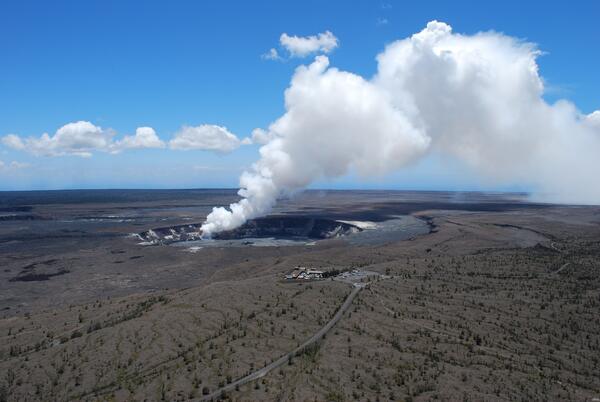
USGS Hawaiian Volcano Observatory Monitors Kilauea's Summit Eruption
USGS Hawaiian Volcano Observatory Monitors Kilauea's Summit EruptionThe USGS Hawaiian Volcano Observatory (foreground) is located on the caldera rim of Kilauea Volcano, Hawai'i—the most active volcano in the world. The observatory's location provides an excellent view of summit eruptive activity, which began in 2008.

USGS Hawaiian Volcano Observatory
The USGS Hawaiian Volcano Observatory is perched on the rim of Kilauea Volcano's summit caldera (next to the Thomas A. Jaggar Museum in Hawai'i Volcanoes National Park), providing a spectacular view of the active vent in Halema‘uma‘u Crater.
The USGS Hawaiian Volcano Observatory is perched on the rim of Kilauea Volcano's summit caldera (next to the Thomas A. Jaggar Museum in Hawai'i Volcanoes National Park), providing a spectacular view of the active vent in Halema‘uma‘u Crater.

Meandering Stream on the North Dakota Plains
A meandering stream that was a possible biomonitoring site for a USGS project in North Dakota.
A meandering stream that was a possible biomonitoring site for a USGS project in North Dakota.

Polar Bears along Arctic Sea Ice
Polar bears along sea ice in the Arctic Ocean.
Polar bears along sea ice in the Arctic Ocean.

Barrow, Alaska
This is a view of Barrow, Alaska from a helicopter.
This is a view of Barrow, Alaska from a helicopter.
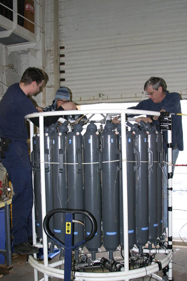
Preparing Conductivity Temperature Depth Profiler (CTD)
Preparing Conductivity Temperature Depth Profiler (CTD)Scientists are preparing the Conductivity Temperature Depth Profiler (CTD) before it is placed in the Arctic Ocean to collect data.
Preparing Conductivity Temperature Depth Profiler (CTD)
Preparing Conductivity Temperature Depth Profiler (CTD)Scientists are preparing the Conductivity Temperature Depth Profiler (CTD) before it is placed in the Arctic Ocean to collect data.

Conductivity Temperature Depth Profiler (CTD)
U.S. Coast Guard member is preparing the Conductivity Temperature Depth Profiler (CTD) for deployment in the Arctic Ocean. The CTD collects water samples and measures conductivity and temperature as a function of water depth.
U.S. Coast Guard member is preparing the Conductivity Temperature Depth Profiler (CTD) for deployment in the Arctic Ocean. The CTD collects water samples and measures conductivity and temperature as a function of water depth.

Polar Bears along Arctic Sea Ice
Polar bears along sea ice in the Arctic Ocean.
Polar bears along sea ice in the Arctic Ocean.

Pilot Discussing Canadian Helicopter Operations
A Canadian helicopter pilot is discussing the helicopter's operations to U.S. Coast Guard members. The helicopter flew from the Canadian Coast Guard Ship Louis S. St. Laurent to the U.S. Coast Guard Cutter Healy. This is in the Arctic Ocean during a scientific expedition to map the seafloor.
A Canadian helicopter pilot is discussing the helicopter's operations to U.S. Coast Guard members. The helicopter flew from the Canadian Coast Guard Ship Louis S. St. Laurent to the U.S. Coast Guard Cutter Healy. This is in the Arctic Ocean during a scientific expedition to map the seafloor.
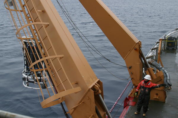
Conductivity Temperature Depth Profiler (CTD) in Arctic Ocean
Conductivity Temperature Depth Profiler (CTD) in Arctic OceanThe Conductivity Temperature Depth Profiler (CTD) is being lowered in the Arctic Ocean to collect water samples and measure conductivity and temperature as a function of water depth.

Conductivity Depth Profiler
A member of the U.S. Coast Guard is preparing the Conductivity Temperature Depth Profiler (CTD) to be deployed in the Arctic Ocean to collect data.
A member of the U.S. Coast Guard is preparing the Conductivity Temperature Depth Profiler (CTD) to be deployed in the Arctic Ocean to collect data.