
Helicopter view of U.S. Coast Guard Cutter Healy (left) and Canadian Coast Guard Ship Louis S. St. Laurent (right) on the Arctic Ocean. The ships are coming together because the crews are planning to meet and learn the operations of the other ship. This was during a scientific expedition to map the Arctic seafloor.
Images
Images
Filter Total Items: 9448

U.S. and Canadian Ships in Arctic Ocean
Helicopter view of U.S. Coast Guard Cutter Healy (left) and Canadian Coast Guard Ship Louis S. St. Laurent (right) on the Arctic Ocean. The ships are coming together because the crews are planning to meet and learn the operations of the other ship. This was during a scientific expedition to map the Arctic seafloor.

U.S. and Canadian Ships in Arctic Ocean
Helicopter view of Canadian Coast Guard Ship Louis S. St. Laurent (left) and U.S. Coast Guard Cutter Healy (right) on the Arctic Ocean. The ships are coming together because the crews are planning to meet and learn the operations of the other ship. This was during a scientific expedition to map the Arctic seafloor.
Helicopter view of Canadian Coast Guard Ship Louis S. St. Laurent (left) and U.S. Coast Guard Cutter Healy (right) on the Arctic Ocean. The ships are coming together because the crews are planning to meet and learn the operations of the other ship. This was during a scientific expedition to map the Arctic seafloor.

Canadian Coast Guard Ship in the Arctic
Helicopter view of Canadian Coast Guard Ship Louis S. St. Laurent on the Arctic Ocean. This was during a scientific expedition to map the Arctic seafloor.
Helicopter view of Canadian Coast Guard Ship Louis S. St. Laurent on the Arctic Ocean. This was during a scientific expedition to map the Arctic seafloor.

Healy Science Party
Some of the science party on U.S. Coast Guard Cutter Healy during a 2008 scientific expedition to map the Arctic seafloor.
Some of the science party on U.S. Coast Guard Cutter Healy during a 2008 scientific expedition to map the Arctic seafloor.

Reviewing Arctic Data
USGS scientist Jonathan Childs, also chief scientist on Healy during this expedition, reviews incoming seismic data. This was during a scientific expedition to map the Arctic seafloor.
USGS scientist Jonathan Childs, also chief scientist on Healy during this expedition, reviews incoming seismic data. This was during a scientific expedition to map the Arctic seafloor.

USGS and NOAA Monitor Arctic Sea Ice
USGS scientist Jonathan Childs and NOAA oceanographer Pablo Clemente-Colón, also Chief Scientist of the National Ice Center, looking out on the Arctic sea ice. This was during a scientific expedition to map the Arctic seafloor.
USGS scientist Jonathan Childs and NOAA oceanographer Pablo Clemente-Colón, also Chief Scientist of the National Ice Center, looking out on the Arctic sea ice. This was during a scientific expedition to map the Arctic seafloor.

Driving Healy in the Arctic
Canadian Coast Guard member takes a turn driving U.S. Coast Guard Cutter Healy. This was during a scientific expedition to map the Arctic seafloor.
Canadian Coast Guard member takes a turn driving U.S. Coast Guard Cutter Healy. This was during a scientific expedition to map the Arctic seafloor.

Dye tracer study on the Kootenai River
Aerial view of a USGS dye tracer study done on the Kootenai River in Idaho.
Aerial view of a USGS dye tracer study done on the Kootenai River in Idaho.

Louis S. St. Laurent
Louis S. St. Laurent finding a path through the Arctic sea ice.
Louis S. St. Laurent finding a path through the Arctic sea ice.

U.S. Coast Guard Cutter Healy
U.S. Coast Guard Cutter Healy in the Arctic.
U.S. Coast Guard Cutter Healy in the Arctic.

Barrow, Alaska
This is a view of Barrow, Alaska from a helicopter.
This is a view of Barrow, Alaska from a helicopter.

Polar Bears along Arctic Sea Ice
Polar bears along sea ice in the Arctic Ocean.
Polar bears along sea ice in the Arctic Ocean.

Polar Bears along Arctic Sea Ice
Polar bears along sea ice in the Arctic Ocean.
Polar bears along sea ice in the Arctic Ocean.

Arctic Sea Ice
Image of sea ice along the Arctic Ocean. This image was taken while onboard U.S. Coast Guard Cutter Healy.
Image of sea ice along the Arctic Ocean. This image was taken while onboard U.S. Coast Guard Cutter Healy.

Polar Bears along Arctic Sea Ice
Polar bears along sea ice in the Arctic Ocean.
Polar bears along sea ice in the Arctic Ocean.

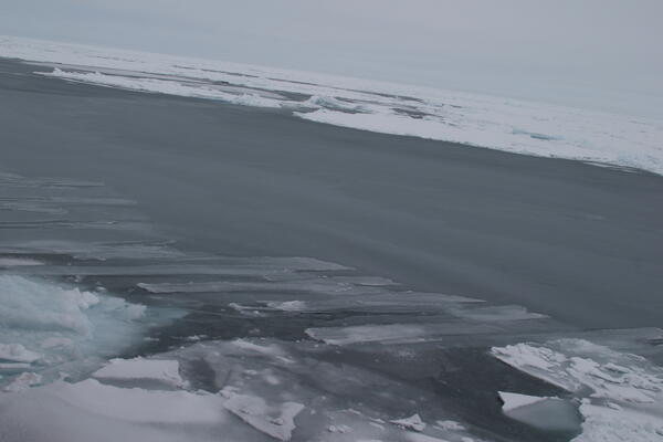
Arctic Sea Ice
This is an image of nilas, which is thin ice, in the Arctic Ocean. As nilas comes together like fingers, which is known as finger rafting, it creates thicker ice called young ice.
This is an image of nilas, which is thin ice, in the Arctic Ocean. As nilas comes together like fingers, which is known as finger rafting, it creates thicker ice called young ice.
Arctic Sea Ice
Image of Arctic sea ice.

Arctic Sea Ice
Image of sea ice along the Arctic Ocean. This is the bow of U.S. Coast Guard Cutter Healy.
Image of sea ice along the Arctic Ocean. This is the bow of U.S. Coast Guard Cutter Healy.

Arctic Sea Ice
Image of sea ice along the Arctic Ocean.
Image of sea ice along the Arctic Ocean.

Arctic Sea Ice
Image of sea ice along the Arctic Ocean.
Image of sea ice along the Arctic Ocean.

Arctic Sea Ice
Image of sea ice along the Arctic Ocean.
Image of sea ice along the Arctic Ocean.