
A male northern pintail duck in Japan.
Images
Images
Filter Total Items: 9454

Northern Pintail Duck
A male northern pintail duck in Japan.

Piping Plover
Chicks and eggs of piping plovers. The piping plover is a small migratory shorebird listed as endangered in Canada and the U.S. Great Lakes, and threatened throughout the remainder of its U.S. breeding and winter range.
Chicks and eggs of piping plovers. The piping plover is a small migratory shorebird listed as endangered in Canada and the U.S. Great Lakes, and threatened throughout the remainder of its U.S. breeding and winter range.

Piping Plover
An adult piping plover. The piping plover is a small migratory shorebird listed as endangered in Canada and the U.S. Great Lakes, and threatened throughout the remainder of its U.S. breeding and winter range. Recent surveys indicate that there are only about 8,000 adults in existence.
An adult piping plover. The piping plover is a small migratory shorebird listed as endangered in Canada and the U.S. Great Lakes, and threatened throughout the remainder of its U.S. breeding and winter range. Recent surveys indicate that there are only about 8,000 adults in existence.
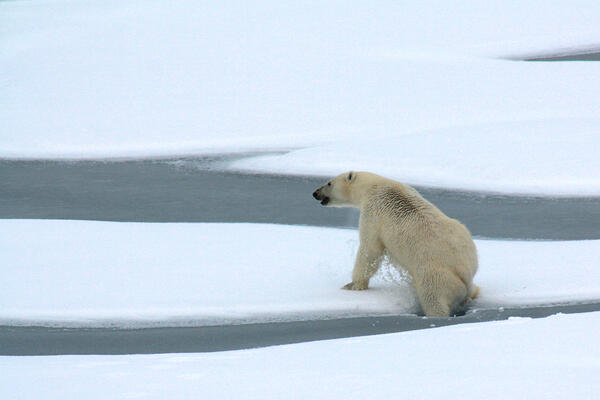
Polar Bear Breaks Ice
A polar bear breaks through thin Actic Ocean ice Aug. 23, 2009.
A polar bear breaks through thin Actic Ocean ice Aug. 23, 2009.

California Condor
California condors are one of the most endangered birds in North America. In the early 1990s, captive-bred condors were reintroduced into the wild in California. As of January 2010, about 190 condors now live in the wild and more reintroductions are being considered.
California condors are one of the most endangered birds in North America. In the early 1990s, captive-bred condors were reintroduced into the wild in California. As of January 2010, about 190 condors now live in the wild and more reintroductions are being considered.

Bison at Yellowstone National Park
Plains bison in winter at Yellowstone National Park.
Plains bison in winter at Yellowstone National Park.

Floodwater at Wild Rice River
Home surrounded by floodwater from Wild Rice River. Photo taken from bridge at 174th Ave and 124th St southwest of Horace, ND.
Home surrounded by floodwater from Wild Rice River. Photo taken from bridge at 174th Ave and 124th St southwest of Horace, ND.

Floodwater at Wild Rice River
USGS personnel at work using acoustic doppler on bridge over Wild Rice River. Photo taken at 174th Ave and 124th St southwest of Horace, ND.
USGS personnel at work using acoustic doppler on bridge over Wild Rice River. Photo taken at 174th Ave and 124th St southwest of Horace, ND.

Floodwater at Wild Rice River
Floodwater at Wild Rice River. Photo taken from bridge at 174th Ave and 124th St southwest of Horace, ND.
Floodwater at Wild Rice River. Photo taken from bridge at 174th Ave and 124th St southwest of Horace, ND.

Floodwater at Wild Rice River
Acoustic doppler used to record measurements on Wild Rice River during 2010 flood. Photo taken from bridge at 174th Ave and 124th St southwest of Horace, ND.
Acoustic doppler used to record measurements on Wild Rice River during 2010 flood. Photo taken from bridge at 174th Ave and 124th St southwest of Horace, ND.

USGS Installing Seismometers in Haiti
The Hotel Montana, shown here, is a portable seismometer site. USGS Seismologists Doug Given, Susan Hough, Mark Meremonte, and J. Zebulon Maharrey traveled to Haiti shortly after the magnitude-7 earthquake struck Port-au-Prince on Jan. 12, 2010 to install seismometers. Seismometers monitor the earth's movement and can detect and measure aftershocks.
The Hotel Montana, shown here, is a portable seismometer site. USGS Seismologists Doug Given, Susan Hough, Mark Meremonte, and J. Zebulon Maharrey traveled to Haiti shortly after the magnitude-7 earthquake struck Port-au-Prince on Jan. 12, 2010 to install seismometers. Seismometers monitor the earth's movement and can detect and measure aftershocks.

Earthquake Resistant Cathedral in Chile
A cathedral in the central square of Chillán, Chile replaces the ancient cathedral that collapsed during the strong earthquake of 1939. This modern structure was constructed with earthquake resistance as the primary consideration. The only damage caused by the M 8.8 earthquake on Feb. 27, 2010 was broken windows.
A cathedral in the central square of Chillán, Chile replaces the ancient cathedral that collapsed during the strong earthquake of 1939. This modern structure was constructed with earthquake resistance as the primary consideration. The only damage caused by the M 8.8 earthquake on Feb. 27, 2010 was broken windows.

High-jumping Silver Carp
Silver carp are a large a troublesome invasive species from Asia found in the great rivers of the central United States. Silver carp have been observed to jump in response to rocks thrown in the water, passing trains, geese taking off from the water, or just when they unexpectedly find themselves in a tight place.
Silver carp are a large a troublesome invasive species from Asia found in the great rivers of the central United States. Silver carp have been observed to jump in response to rocks thrown in the water, passing trains, geese taking off from the water, or just when they unexpectedly find themselves in a tight place.

Destruction in Downtown Concepcion, Chile
A masonry building in the downtown part of Concepcion, Chile partially collapsed as a result of the M 8.8 earthquake on Feb. 27, 2010. Most modern buildings in Concepcion were undamaged during the earthquake due to the city's adoption of adequate building standards. However, many masonry buildings such as this one were heavily damaged.
A masonry building in the downtown part of Concepcion, Chile partially collapsed as a result of the M 8.8 earthquake on Feb. 27, 2010. Most modern buildings in Concepcion were undamaged during the earthquake due to the city's adoption of adequate building standards. However, many masonry buildings such as this one were heavily damaged.

Tsunami-Ready Office Buildings
These offices buildings in Concepcion, Chile were built to be tsunami-ready. They are elevated some 10 meters (32 feet) above the ground surface, such that a tsunami inundation would pass below without causing damage.
These offices buildings in Concepcion, Chile were built to be tsunami-ready. They are elevated some 10 meters (32 feet) above the ground surface, such that a tsunami inundation would pass below without causing damage.

Collapsed Building
This masonry office building in the downtown area of Concepcion, Chile collapsed as a result of the M 8.8 earthquake on Feb. 27, 2010. The construction of this building predates the establishment of strict building codes in Chile, put in place following the devastating earthquake of 1960.
This masonry office building in the downtown area of Concepcion, Chile collapsed as a result of the M 8.8 earthquake on Feb. 27, 2010. The construction of this building predates the establishment of strict building codes in Chile, put in place following the devastating earthquake of 1960.

Tracking Curlews
Curlews migrate long distances each year. Captured birds are quickly removed from mist nets and transported to the care of a veterinarian, who performs the implant surgeries to outfit the bird with a tracking device. In June 2007, USGS scientists tagged 13 curlews with satellite transmitters at their southern breeding area in Alaska.
Curlews migrate long distances each year. Captured birds are quickly removed from mist nets and transported to the care of a veterinarian, who performs the implant surgeries to outfit the bird with a tracking device. In June 2007, USGS scientists tagged 13 curlews with satellite transmitters at their southern breeding area in Alaska.

Bristle-thighed Curlew
A distinctive feature of the Bristle-thighed Curlew is its cinnamon-colored rump and tail. This feature helps distinguish curlews from similar species like the Whimbrel (N. phaeopus), particularly in places where the two species overlap in Alaska and Oceania. These curlews migrate long distances each year.
A distinctive feature of the Bristle-thighed Curlew is its cinnamon-colored rump and tail. This feature helps distinguish curlews from similar species like the Whimbrel (N. phaeopus), particularly in places where the two species overlap in Alaska and Oceania. These curlews migrate long distances each year.

Devils Hole Habitat in the Mojave Desert
The endangered Devils Hole pupfish lives only in Devils Hole in the Mojave Desert.
The endangered Devils Hole pupfish lives only in Devils Hole in the Mojave Desert.
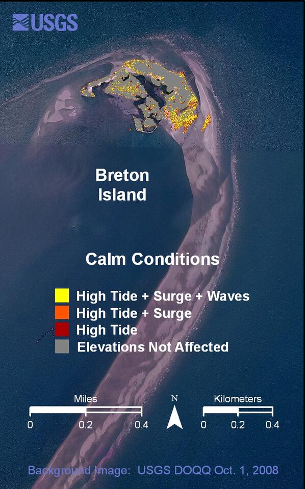
Breton Island calm conditions weather scenario
Breton Island calm conditions weather scenario.
Breton Island calm conditions weather scenario.