
A USGS technician collects a water sample at the Faka Union Canal Weir #1, Collier County, Florida. The sample was used to help determine the source of the warm water responsible for the site's popularity among manatees as a warm water refuge.
Images
Images
Filter Total Items: 9454

USGS Technician Collects Water Sample at a Weir
A USGS technician collects a water sample at the Faka Union Canal Weir #1, Collier County, Florida. The sample was used to help determine the source of the warm water responsible for the site's popularity among manatees as a warm water refuge.

Port-au-Prince Before the Earthquake
High resolution satellite imagery showed the landscape and building damages before and after the magnitude-7 earthquake hit Haiti in the beginning of 2010. This image was taken before the earthquake.
High resolution satellite imagery showed the landscape and building damages before and after the magnitude-7 earthquake hit Haiti in the beginning of 2010. This image was taken before the earthquake.

Harmful Algal Blooms
You may notice a green, red or brown film on your favorite boating or swimming area in the summer. This coloring could mean that the water is affected by harmful algal blooms. Harmful algal blooms are an accumulation of tiny organisms known as algae and can release harmful toxins into the environment.
You may notice a green, red or brown film on your favorite boating or swimming area in the summer. This coloring could mean that the water is affected by harmful algal blooms. Harmful algal blooms are an accumulation of tiny organisms known as algae and can release harmful toxins into the environment.

Lava Entry near Kalapana
View of the western edge of the western ocean entry delta near Kalapana.
View of the western edge of the western ocean entry delta near Kalapana.

Pahoehoe Toe Advancing on Beach
The Puhiokalaikini entry continues to expand eastward, as small pahoehoe toes advanced on the new black sand beach below the seacliff.
The Puhiokalaikini entry continues to expand eastward, as small pahoehoe toes advanced on the new black sand beach below the seacliff.

Distant Fume from Lava Entry
View looking toward the ocean entries in the distance. The 'Ili'ili entry is marked by the tiny plume to the left. The very broad Puhiokalaikini entry comprises the rest of the plumes along the shoreline. The tube system feeding the ocean entries is delineated by the fume in the foreground.
View looking toward the ocean entries in the distance. The 'Ili'ili entry is marked by the tiny plume to the left. The very broad Puhiokalaikini entry comprises the rest of the plumes along the shoreline. The tube system feeding the ocean entries is delineated by the fume in the foreground.

Lava Consuming Piece of Shrubbery
Lava was only slowly oozing from the edge of the flow adjacent to the road. In this photo, a piece of shrubbery is slowly consumed by the lava.
Lava was only slowly oozing from the edge of the flow adjacent to the road. In this photo, a piece of shrubbery is slowly consumed by the lava.

White Tail Deer
Deer in Shenandoah National Park.
Deer in Shenandoah National Park.
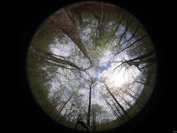
Hemispherical Photo
Madison river weather station site, Shenandoah National Park.
Madison river weather station site, Shenandoah National Park.
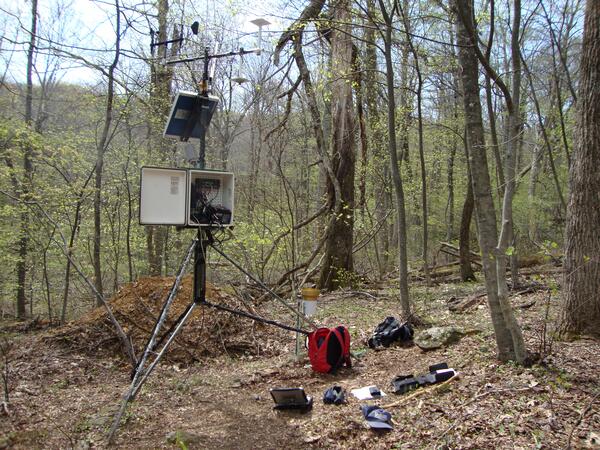
Weather Station
Weather station site, Shenandoah National Park.
Weather station site, Shenandoah National Park.

Seining Blocked-off Mosquito Ditch
Scientists pull a seine net through a blocked-off section of a man-made ditch to estimate fish abundance.
Scientists pull a seine net through a blocked-off section of a man-made ditch to estimate fish abundance.

Seining, Everglades National Park
Scientists pull a seine net through an intertidal creek to estimate fish abundance.
Scientists pull a seine net through an intertidal creek to estimate fish abundance.

Sunrise Tarpon Bay Shark River
Sunrise over a mangrove shoreline, Shark River, Everglades National Park.
Sunrise over a mangrove shoreline, Shark River, Everglades National Park.

Juvenile Tarpon in Mangrove Nursery Area
USGS SCEP displays juvenile tarpon captured in a poorly-connected tidal pond.
USGS SCEP displays juvenile tarpon captured in a poorly-connected tidal pond.

Measuring Flow From a Mangrove Forest
USGS scientist measures water velocity as part of estimating flow from a mangrove forest.
USGS scientist measures water velocity as part of estimating flow from a mangrove forest.

Old Man Tree
Tree after spring blizzard.

Closing Seine Around Pivot Pole, Everglades National Park
Closing Seine Around Pivot Pole, Everglades National ParkSeining for fish in open water necessitates closing the seine quickly to avoid fish escape. Closing the seine around a pole offshore accomplishes this objective in sampling.
Closing Seine Around Pivot Pole, Everglades National Park
Closing Seine Around Pivot Pole, Everglades National ParkSeining for fish in open water necessitates closing the seine quickly to avoid fish escape. Closing the seine around a pole offshore accomplishes this objective in sampling.

Tidepool Anemone
Tide pools provide habitat for a wide variety of Puget Sound flora and fauna. During low tides, the captive inhabitants of tide pools may be closely inspected.
Tide pools provide habitat for a wide variety of Puget Sound flora and fauna. During low tides, the captive inhabitants of tide pools may be closely inspected.

Flat Cays, U.S. Virgin Islands Coral Reef
Shallow coral reefs in the U.S. Virgin Islands are in jeopardy due to climate warming and ocean acidification.
Shallow coral reefs in the U.S. Virgin Islands are in jeopardy due to climate warming and ocean acidification.

Red Knots at Delaware Bay
Red knots, an at-risk shorebird, at Delaware Bay. Red knots like to feed on horseshoe crab eggs to refuel after their marathon migrations of some 10,000 miles. Declines of horseshoe crabs and red knots seem to be related.
Red knots, an at-risk shorebird, at Delaware Bay. Red knots like to feed on horseshoe crab eggs to refuel after their marathon migrations of some 10,000 miles. Declines of horseshoe crabs and red knots seem to be related.
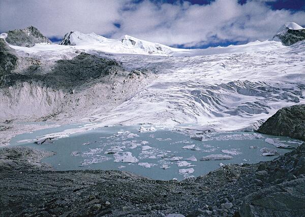
Debris-Free Plateau Glacier
Small debris-free plateau glacier with glacier lakes at Gangrinchemzoe Pass at 5,200 m, south of the main Himalayan divide, Bhutan. Image courtesy of Shuji Iwata, Tokyo Metropolitan University, Japan.
Small debris-free plateau glacier with glacier lakes at Gangrinchemzoe Pass at 5,200 m, south of the main Himalayan divide, Bhutan. Image courtesy of Shuji Iwata, Tokyo Metropolitan University, Japan.