
A class photo! The entire gang of adolescent whooping crane chicks together at the USGS Patuxent Wildlife Research Center in Laurel, Md. The chicks, hatched and raised by USGS caretakers, are being released into the wild in Louisiana in February 2011. It is a milestone for the state and for the birds, which have not lived in the state since the 1950s.
Images
Images
Filter Total Items: 9454

The USGS Whooping Crane Flock Class Picture
A class photo! The entire gang of adolescent whooping crane chicks together at the USGS Patuxent Wildlife Research Center in Laurel, Md. The chicks, hatched and raised by USGS caretakers, are being released into the wild in Louisiana in February 2011. It is a milestone for the state and for the birds, which have not lived in the state since the 1950s.

Whooping Crane Chick L5-10
This adolescent chick, hatched and raised at the USGS Patuxent Wildlife Research Center, is one of ten whooping cranes being released in Louisiana in February 2011. It is a milestone for the state and for the birds, which have not lived in the state since the 1950s.
This adolescent chick, hatched and raised at the USGS Patuxent Wildlife Research Center, is one of ten whooping cranes being released in Louisiana in February 2011. It is a milestone for the state and for the birds, which have not lived in the state since the 1950s.

Whooping Crane Chick L6-10
This adolescent chick, hatched and raised at the USGS Patuxent Wildlife Research Center, is one of ten whooping cranes being released in Louisiana in February 2011. It is a milestone for the state and for the birds, which have not lived in the state since the 1950s.
This adolescent chick, hatched and raised at the USGS Patuxent Wildlife Research Center, is one of ten whooping cranes being released in Louisiana in February 2011. It is a milestone for the state and for the birds, which have not lived in the state since the 1950s.

Thomas A. Jaggar, Hawaiian Volcano Observatory
Thomas A. Jaggar founded the Hawaiian Volcano Observatory in 1912 and served as its Director until 1940. Shown here in 1925, Jaggar is at work in HVO's first building, which, at the time, was located on the northeast rim of Kīlauea Volcano’s summit caldera, near the present-day Volcano House hotel.
Thomas A. Jaggar founded the Hawaiian Volcano Observatory in 1912 and served as its Director until 1940. Shown here in 1925, Jaggar is at work in HVO's first building, which, at the time, was located on the northeast rim of Kīlauea Volcano’s summit caldera, near the present-day Volcano House hotel.

Copper-Striped Blue-Tailed Skink
A copper-striped blue-tailed skink (Emoia impar) photographed in Samoa during a USGS field survey.
A copper-striped blue-tailed skink (Emoia impar) photographed in Samoa during a USGS field survey.

Gale crater
Infrared mosaic image of Mars Gale crater by the Thermal Emission Imaging Spectrometer (THEMIS) of the USGS Astrogeology Science Center and Arizona State University. The Mars Science Laboratory is scheduled to land in Gale crater Aug. 5, 2012.
Infrared mosaic image of Mars Gale crater by the Thermal Emission Imaging Spectrometer (THEMIS) of the USGS Astrogeology Science Center and Arizona State University. The Mars Science Laboratory is scheduled to land in Gale crater Aug. 5, 2012.

Zebra Finch
Erik Hofmeister, NWHC veterinarian and research scientist, holds a zebra finch, a species which serves as a laboratory model for study of avian diseases.
Erik Hofmeister, NWHC veterinarian and research scientist, holds a zebra finch, a species which serves as a laboratory model for study of avian diseases.

Northeast Rim of the Blackbird Cobalt-Copper Mine
USGS scientist Tom Frost stands on the northeast rim of the Blacktail pit of the Blackbird cobalt-copper mine, in the Salmon River Mountains of east-central Idaho.
USGS scientist Tom Frost stands on the northeast rim of the Blacktail pit of the Blackbird cobalt-copper mine, in the Salmon River Mountains of east-central Idaho.

Searching for Sulfides at the Blackbird Cobalt-Copper Mine
Searching for Sulfides at the Blackbird Cobalt-Copper MineUSGS scientist Art Bookstrom uses a hand-lens to search for sulfide minerals in oxidized copper-cobalt-bearing siltite of the banded siltite unit of the Apple Creek Formation, exposed in the Blacktail pit of the Blackbird cobalt-copper mine, Salmon River Mountains, east-central Idaho.

A Gossan at the Blackbird Cobalt-Copper Mine
USGS scientist Art Bookstrom maps and samples a gossan, developed on tightly folded, mineralized, metamorphosed, and weathered banded siltite, exposed on the southwest rim of the Blacktail pit of the Blackbird cobalt-copper mine, in the Salmon River Mountains of east-central Idaho. The gossan is overlain by unconsolidated colluvial debris.
USGS scientist Art Bookstrom maps and samples a gossan, developed on tightly folded, mineralized, metamorphosed, and weathered banded siltite, exposed on the southwest rim of the Blacktail pit of the Blackbird cobalt-copper mine, in the Salmon River Mountains of east-central Idaho. The gossan is overlain by unconsolidated colluvial debris.

Banded Siltite at the Blackbird Cobalt-Copper Mine
Banded Siltite at the Blackbird Cobalt-Copper MineUSGS scientist Steve Box takes an oriented sample of folded, crenulated, and metamorphosed banded siltite, exposed in the Blacktail pit of the Blackbird cobalt-copper mine, in the Salmon River Mountains of east-central Idaho.

Monitoring the Colorado River
A member of the USGS Glen Canyon Adaptive Management Working Group in Flagstaff, Ariz., monitors the Colorado River downstream of Glen Canyon Dam.
A member of the USGS Glen Canyon Adaptive Management Working Group in Flagstaff, Ariz., monitors the Colorado River downstream of Glen Canyon Dam.

Washington Monument in DC
Washington Monument in DC, with the cherry blossoms in bloom.
Washington Monument in DC, with the cherry blossoms in bloom.
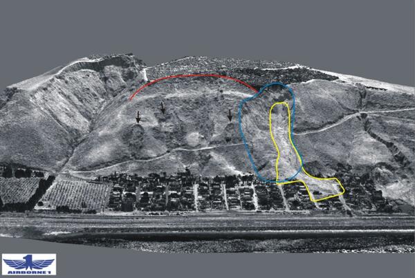
La Conchita
An oblique LIDAR image of La Conchita, Calif., reveals the community’s grim landslide history. The 1995 landslide is outlined in blue and the 2005 landslide in yellow, while a red line overhead outlines the main scarp of an ancient landslide that involved the entire bluff. Arrows show other landslides in the area.
An oblique LIDAR image of La Conchita, Calif., reveals the community’s grim landslide history. The 1995 landslide is outlined in blue and the 2005 landslide in yellow, while a red line overhead outlines the main scarp of an ancient landslide that involved the entire bluff. Arrows show other landslides in the area.

Memorial Stadium, University of Nebraska Cornhuskers
Memorial Stadium, University of Nebraska CornhuskersThis image is a High Resolution Orthoimagery, 6-inch spatial resolution, Lancaster County Dataset, taken in April 2007. High Resolution Orthoimagery looks like a photograph but any distortions caused by the tilt of the camera or topography of the land have been removed, so orthoimages are geospatially accurate and can be used as maps.

Natural Gas Flare Stack
A flare stack to burn excess natural gas at a natural gas drill site in the Marcellus Shale gas play of western Pennsylvania.
A flare stack to burn excess natural gas at a natural gas drill site in the Marcellus Shale gas play of western Pennsylvania.

Bakken Drill Rig
A drill rig in the Bakken oil field in Stark County, western North Dakota.
A drill rig in the Bakken oil field in Stark County, western North Dakota.

Elk Crossing
Elk traveling on winter range in the northwestern Greater Yellowstone Ecosystem after crossing the Madison River near Ennis, Montana, 2008.
Elk traveling on winter range in the northwestern Greater Yellowstone Ecosystem after crossing the Madison River near Ennis, Montana, 2008.

Elk Traveling
Elk traveling across winter range in the northwestern Greater Yellowstone Ecosystem near the Gardiner River in Yellowstone National Park, 2008.
Elk traveling across winter range in the northwestern Greater Yellowstone Ecosystem near the Gardiner River in Yellowstone National Park, 2008.

Penobscot River Work - Station 4 2009
A photo taken before the Great Works Dam was removed (likely in 2009), looking upstream from a boat just upstream of the Great Works Dam.
A photo taken before the Great Works Dam was removed (likely in 2009), looking upstream from a boat just upstream of the Great Works Dam.

Culvert Trap
Researchers with IGBST have tranquilized the bear and prepare to lift it out of the trap and onto the tarp for data collection. Once on the tarp the bear is easier to move.
Researchers with IGBST have tranquilized the bear and prepare to lift it out of the trap and onto the tarp for data collection. Once on the tarp the bear is easier to move.