
A truffle of Elaphomyces spp. with Elaphocordyceps ophioglossoides, a parasitic ascomycetous fungus, at Kumbrabow State Forest in West Virginia.
Images
Images
Filter Total Items: 9449

Truffle
A truffle of Elaphomyces spp. with Elaphocordyceps ophioglossoides, a parasitic ascomycetous fungus, at Kumbrabow State Forest in West Virginia.

Measuring Streamflow in 1920
H.D. McGlashan measures streamflow in the Merced River, circa 1920. Multiple velocity and water-depth measurements along a stream cross section are used to calculate the total volume of water passing a certain location over a specific period of time (cubic feet per second).
Location: Merced River, Yosemite National Park, California

Aerial Over Weka Dur Gold Deposit, Badakhshan
Aerial view over Weka Dur, Afghanistan’s largest known gold deposit, Badakhshan Province.
Aerial view over Weka Dur, Afghanistan’s largest known gold deposit, Badakhshan Province.
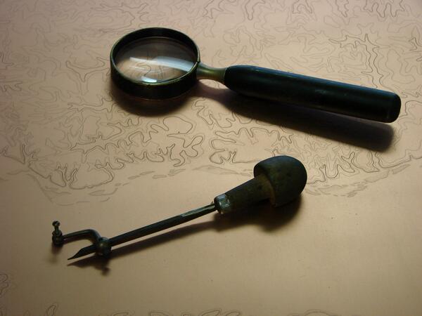
Map Contour Engraving Tools
Tools of the trade for a US Geological Survey engraver- the burin and the hand lens, resting on a contours engraving.
Tools of the trade for a US Geological Survey engraver- the burin and the hand lens, resting on a contours engraving.
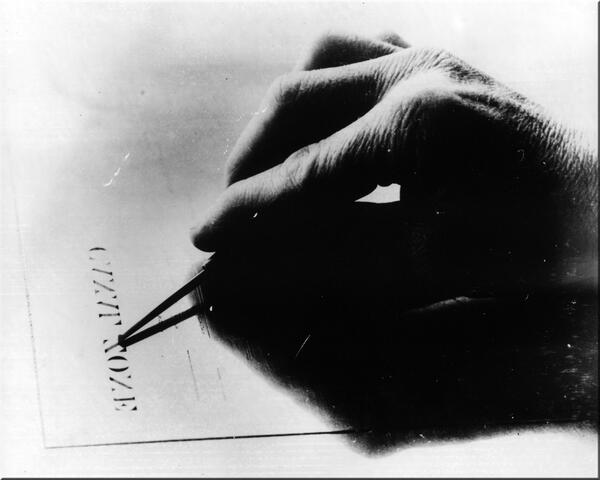
A Steady Hand
The steady hands of a USGS engraver touching up left-reading lettering.
The steady hands of a USGS engraver touching up left-reading lettering.

Panorama of Silverton, Colorado
Panoramic photo of Silverton, Colorado, with Sultan Mountain in the distance. Silverton is the town most directly affected by the Gold King mine blowout.
Panoramic photo of Silverton, Colorado, with Sultan Mountain in the distance. Silverton is the town most directly affected by the Gold King mine blowout.

Forest Overlain by Clouds
Clouds Overlying a Forest.
Clouds Overlying a Forest.

Cascades Frog
A Cascades frog peeks out of the water in Olympic National Park.
A Cascades frog peeks out of the water in Olympic National Park.

Deforestation
Forest cover being removed for cattle pasturage and development. Smoke from bulldozed trees is visible in background with cattle in the foreground.
Forest cover being removed for cattle pasturage and development. Smoke from bulldozed trees is visible in background with cattle in the foreground.

Pacific Lamprey (Lampetra tridentata)
Larval Pacific lamprey collected from the upper Umatilla River in northeastern Oregon.
Larval Pacific lamprey collected from the upper Umatilla River in northeastern Oregon.

Low-level Helicopter Towing a Large Wire-Loop Contraption Hanging From a Cable
Low-level Helicopter Towing a Large Wire-Loop Contraption Hanging From a CableHelicopter towing a large, wire-loop contraption hanging from a cable is turning in air on a relatively clear day in Nebraska.
Low-level Helicopter Towing a Large Wire-Loop Contraption Hanging From a Cable
Low-level Helicopter Towing a Large Wire-Loop Contraption Hanging From a CableHelicopter towing a large, wire-loop contraption hanging from a cable is turning in air on a relatively clear day in Nebraska.

USGS Great Lakes Science Center
Aerial view of the USGS Great lakes Science Center Hammond Bay Biological Station at Hammond Bay, Michigan.

Yosemite Bog-orchid
A rare Yosemite bog-orchid (Platanthera yosemitensis) was identified as a new species in 2007.
A rare Yosemite bog-orchid (Platanthera yosemitensis) was identified as a new species in 2007.

Ahankashan Copper Gold
Light-colored rocks in the foreground overlay a pluton, formed as a plume of magma rose, cooled and deposited minerals in the earth’s crust. Sedimentary rocks dip away from the intrusion.
Light-colored rocks in the foreground overlay a pluton, formed as a plume of magma rose, cooled and deposited minerals in the earth’s crust. Sedimentary rocks dip away from the intrusion.
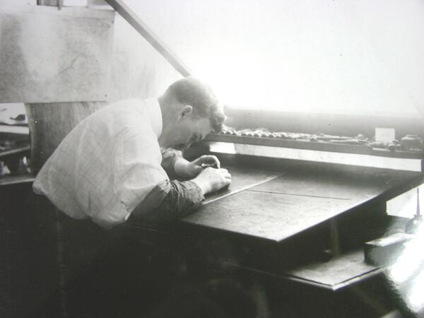
Engraving a Map
With great precision, an engraver carefully cuts away small ribbons of copper to create the contour plate for a US Geological Survey topographic quadrangle.
With great precision, an engraver carefully cuts away small ribbons of copper to create the contour plate for a US Geological Survey topographic quadrangle.

Lithographic Printing Stones for Map-making
In the past, each USGS topographic map typically required 3 individual lithographic stones for printing, one for each color shown on the map.
In the past, each USGS topographic map typically required 3 individual lithographic stones for printing, one for each color shown on the map.

Radiolarians (10 Species)
A photomicrograph depicting the siliceous tests of ten species of marine radiolarians. This image has been inverted to bring out details. Upon death, their tests can form siliceous marine sediments known as radiolarian ooze.
A photomicrograph depicting the siliceous tests of ten species of marine radiolarians. This image has been inverted to bring out details. Upon death, their tests can form siliceous marine sediments known as radiolarian ooze.

Diatoms (50 Species)
Photomicrograph depicting the siliceous frustules of fifty species of diatoms arranged within a circular shape. Diatoms form the base of many marine and aquatic food chains and upon death, their glassy frustules form sediments known as diatomaceous earth.
Photomicrograph depicting the siliceous frustules of fifty species of diatoms arranged within a circular shape. Diatoms form the base of many marine and aquatic food chains and upon death, their glassy frustules form sediments known as diatomaceous earth.

Lunch Lake in the Seven Lakes Basin
Deer in the mist by Lunch Lake in the Seven Lakes Basin of Olympic National Park.
Deer in the mist by Lunch Lake in the Seven Lakes Basin of Olympic National Park.

Salamander
An unknown hybrid species of salamander captured in Olympic National Park, Washington.
An unknown hybrid species of salamander captured in Olympic National Park, Washington.

Deforestation
Forest cover being removed for cattle pasturage and development. Bulldozer and smoke from bulldozed trees in the background with cattle in the foreground.
Forest cover being removed for cattle pasturage and development. Bulldozer and smoke from bulldozed trees in the background with cattle in the foreground.