
Forest cover being removed for cattle pasturage and development. Smoke from bulldozed trees is visible in background with cattle in the foreground.
Images
Images
Filter Total Items: 9449

Deforestation
Forest cover being removed for cattle pasturage and development. Smoke from bulldozed trees is visible in background with cattle in the foreground.

Pacific Lamprey (Lampetra tridentata)
Larval Pacific lamprey collected from the upper Umatilla River in northeastern Oregon.
Larval Pacific lamprey collected from the upper Umatilla River in northeastern Oregon.

Low-level Helicopter Towing a Large Wire-Loop Contraption Hanging From a Cable
Low-level Helicopter Towing a Large Wire-Loop Contraption Hanging From a CableHelicopter towing a large, wire-loop contraption hanging from a cable is turning in air on a relatively clear day in Nebraska.
Low-level Helicopter Towing a Large Wire-Loop Contraption Hanging From a Cable
Low-level Helicopter Towing a Large Wire-Loop Contraption Hanging From a CableHelicopter towing a large, wire-loop contraption hanging from a cable is turning in air on a relatively clear day in Nebraska.

USGS Great Lakes Science Center
Aerial view of the USGS Great lakes Science Center Hammond Bay Biological Station at Hammond Bay, Michigan.

Air-quality Monitoring Instruments
Annotated photo of air-quality particulate monitoring instruments, showing temperature and humidity sensors, air-sample inlet tube, wind sensor, power supply, and communication connections.
Annotated photo of air-quality particulate monitoring instruments, showing temperature and humidity sensors, air-sample inlet tube, wind sensor, power supply, and communication connections.

Juvenile Silver Carp
This close-up image is of juvenile silver carp in research tanks at the USGS Upper Midwest Environmental Sciences Center.
This close-up image is of juvenile silver carp in research tanks at the USGS Upper Midwest Environmental Sciences Center.
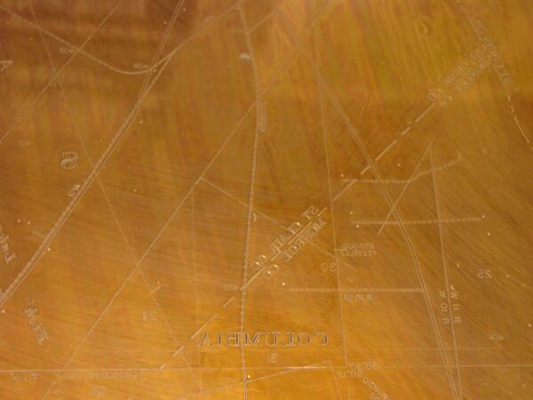
Copper Map Plate Detail
Detail of a “culture” separate, which was represented in the color black on a USGS topographic map.
Detail of a “culture” separate, which was represented in the color black on a USGS topographic map.

Pictographs on Rock
Pictographs at Saguaro National Park. Photographed 2006 or earlier
Pictographs at Saguaro National Park. Photographed 2006 or earlier

Pictographs on Rock
Pictographs at Saguaro National Park. Photographed 2006 or earlier.
Pictographs at Saguaro National Park. Photographed 2006 or earlier.

Cascades Frog
A Cascades frog perched on moss.
A Cascades frog perched on moss.

Measuring a Frog in the Cascades
USGS researchers Brome McCreary (orange vest) and Chris Pearl take measurements on Cascades frog at a mountain lake in Oregon.
USGS researchers Brome McCreary (orange vest) and Chris Pearl take measurements on Cascades frog at a mountain lake in Oregon.

Deforestation
Forest cover being removed for cattle pasturage and development. Smoke from bulldozed trees is visible in background with cattle in the foreground.
Forest cover being removed for cattle pasturage and development. Smoke from bulldozed trees is visible in background with cattle in the foreground.
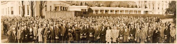
USGS 50th Anniversary White House
In 1929, as part of modest ceremonies to mark the USGS' 50th anniversary, President Hoover invited Director George Otis Smith (who succeeded Walcott in 1907), and other USGS employees in the DC area to a reception at the White House. A professional photographer took a panoramic image of the attendees assembled in the Rose Garden.
In 1929, as part of modest ceremonies to mark the USGS' 50th anniversary, President Hoover invited Director George Otis Smith (who succeeded Walcott in 1907), and other USGS employees in the DC area to a reception at the White House. A professional photographer took a panoramic image of the attendees assembled in the Rose Garden.

Lake Sturgeon in Genesee River, NY
A USGS scientist holds a five-year-old stocked lake sturgeon recaptured during a survival assessment in the Genesee River, New York.
A USGS scientist holds a five-year-old stocked lake sturgeon recaptured during a survival assessment in the Genesee River, New York.

Redbeds Near Herat
Aerial view near Herat. Dark red iron stains hint that other minerals might be found.
Aerial view near Herat. Dark red iron stains hint that other minerals might be found.

Whooping Crane Chick L1-10
This adolescent chick, hatched and raised at the USGS Patuxent Wildlife Research Center, is one of ten whooping cranes being released in Louisiana in February 2011. It is a milestone for the state and for the birds, which have not lived in the state since the 1950s.
This adolescent chick, hatched and raised at the USGS Patuxent Wildlife Research Center, is one of ten whooping cranes being released in Louisiana in February 2011. It is a milestone for the state and for the birds, which have not lived in the state since the 1950s.

The USGS Whooping Crane Flock Class Picture
A class photo! The entire gang of adolescent whooping crane chicks together at the USGS Patuxent Wildlife Research Center in Laurel, Md. The chicks, hatched and raised by USGS caretakers, are being released into the wild in Louisiana in February 2011. It is a milestone for the state and for the birds, which have not lived in the state since the 1950s.
A class photo! The entire gang of adolescent whooping crane chicks together at the USGS Patuxent Wildlife Research Center in Laurel, Md. The chicks, hatched and raised by USGS caretakers, are being released into the wild in Louisiana in February 2011. It is a milestone for the state and for the birds, which have not lived in the state since the 1950s.

Whooping Crane Chick L5-10
This adolescent chick, hatched and raised at the USGS Patuxent Wildlife Research Center, is one of ten whooping cranes being released in Louisiana in February 2011. It is a milestone for the state and for the birds, which have not lived in the state since the 1950s.
This adolescent chick, hatched and raised at the USGS Patuxent Wildlife Research Center, is one of ten whooping cranes being released in Louisiana in February 2011. It is a milestone for the state and for the birds, which have not lived in the state since the 1950s.

Whooping Crane Chick L6-10
This adolescent chick, hatched and raised at the USGS Patuxent Wildlife Research Center, is one of ten whooping cranes being released in Louisiana in February 2011. It is a milestone for the state and for the birds, which have not lived in the state since the 1950s.
This adolescent chick, hatched and raised at the USGS Patuxent Wildlife Research Center, is one of ten whooping cranes being released in Louisiana in February 2011. It is a milestone for the state and for the birds, which have not lived in the state since the 1950s.

Thomas A. Jaggar, Hawaiian Volcano Observatory
Thomas A. Jaggar founded the Hawaiian Volcano Observatory in 1912 and served as its Director until 1940. Shown here in 1925, Jaggar is at work in HVO's first building, which, at the time, was located on the northeast rim of Kīlauea Volcano’s summit caldera, near the present-day Volcano House hotel.
Thomas A. Jaggar founded the Hawaiian Volcano Observatory in 1912 and served as its Director until 1940. Shown here in 1925, Jaggar is at work in HVO's first building, which, at the time, was located on the northeast rim of Kīlauea Volcano’s summit caldera, near the present-day Volcano House hotel.

Copper-Striped Blue-Tailed Skink
A copper-striped blue-tailed skink (Emoia impar) photographed in Samoa during a USGS field survey.
A copper-striped blue-tailed skink (Emoia impar) photographed in Samoa during a USGS field survey.