
Herring larvae 15 days post-hatch. Food in the gut appears orange.
Images
Images
Filter Total Items: 9454

Pacific Herring larvae
Herring larvae 15 days post-hatch. Food in the gut appears orange.

Pacific Herring School
Currently four age classes (0, 1, 2, and 4 year olds) of SPF herring are maintained at the Marrowstone Marine Field Station.
Currently four age classes (0, 1, 2, and 4 year olds) of SPF herring are maintained at the Marrowstone Marine Field Station.

Radio Collared Bears
Once a bear is radio collared, researchers can track its movements with telemetry.
Once a bear is radio collared, researchers can track its movements with telemetry.

Bear Scratch
When looking for a place to set up a trapping location, scientists look for existing bear sign such as scratches on trees and bear scat. Sometimes traps are set in areas that have no obvious bear sign to determine if indeed bears are present.
When looking for a place to set up a trapping location, scientists look for existing bear sign such as scratches on trees and bear scat. Sometimes traps are set in areas that have no obvious bear sign to determine if indeed bears are present.

Measuring the Bear
Researchers with IGBST measure the bear's girth as part of body fitness data collection.
Researchers with IGBST measure the bear's girth as part of body fitness data collection.

Northern Pintail Ducks
A flock of wintering northern pintail ducks takes flight in Northern Honshu, Japan.
A flock of wintering northern pintail ducks takes flight in Northern Honshu, Japan.
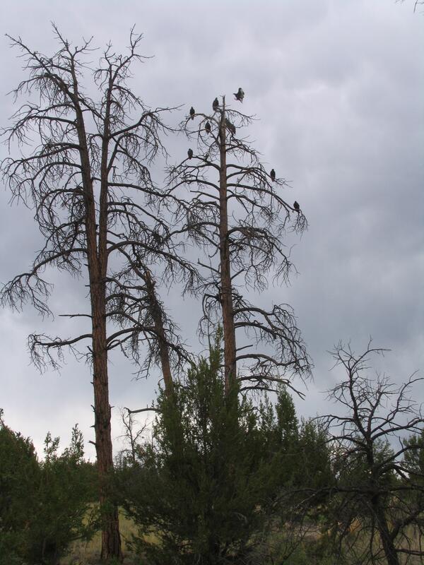
Dead Ponderosas in Jemez, NM
Drought and climate change are causing extensive forest dieback in the U.S. West as well as worldwide. These photos show dead ponderosa pines in the Jemez Mountains of New Mexico killed by a combination of drought stress and attacks by bark beetles on weakened trees.
Drought and climate change are causing extensive forest dieback in the U.S. West as well as worldwide. These photos show dead ponderosa pines in the Jemez Mountains of New Mexico killed by a combination of drought stress and attacks by bark beetles on weakened trees.

Diseased Sea Star
Whitish areas on this diseased sunflower sea star (Pycnopodia helianthoides) are lesions that result in detachment of arms from the central disc.
Whitish areas on this diseased sunflower sea star (Pycnopodia helianthoides) are lesions that result in detachment of arms from the central disc.

Southeast Missouri Helicopter Survey
Residents and visitors should not be alarmed to witness a low-flying helicopter over southeastern Missouri starting in mid to late February, 2014.
Residents and visitors should not be alarmed to witness a low-flying helicopter over southeastern Missouri starting in mid to late February, 2014.

A Desert Tortoise
The Agassiz's desert tortoise, a native of the Mojave Desert.
The Agassiz's desert tortoise, a native of the Mojave Desert.

A Pocketbook Mussel
A pocketbook mussel (Lampsilis cardium). Native freshwater mussels are among the most fascinating, widespread, and endangered animals in fresh waters. They play important ecological roles in our lakes and rivers and their shells are used to produce cultured pearls.
A pocketbook mussel (Lampsilis cardium). Native freshwater mussels are among the most fascinating, widespread, and endangered animals in fresh waters. They play important ecological roles in our lakes and rivers and their shells are used to produce cultured pearls.

Silver Carp Egg
This image of a live silver carp egg specimen was taken with a microscope camera at the USGS Columbia Environmental Research Center. Asian carp are invasive species that could pose substantial environmental risks and economic impacts if they become established.
This image of a live silver carp egg specimen was taken with a microscope camera at the USGS Columbia Environmental Research Center. Asian carp are invasive species that could pose substantial environmental risks and economic impacts if they become established.

Silver Carp Larva
This image of a live silver carp larva was taken with a microscope camera at the USGS Columbia Environmental Research Center. Asian carp are invasive species that could pose substantial environmental risks and economic impacts if they become established.
This image of a live silver carp larva was taken with a microscope camera at the USGS Columbia Environmental Research Center. Asian carp are invasive species that could pose substantial environmental risks and economic impacts if they become established.

Diatoms (50 Species)
A photomicrograph depicting the siliceous frustules of fifty species of diatoms arranged within a circular shape. The image has been inverted to white on black to bring out details. Diatoms form the base of many marine and aquatic foodchains and upon death, their glassy frustules form sediments known as diatomaceous earth.
A photomicrograph depicting the siliceous frustules of fifty species of diatoms arranged within a circular shape. The image has been inverted to white on black to bring out details. Diatoms form the base of many marine and aquatic foodchains and upon death, their glassy frustules form sediments known as diatomaceous earth.
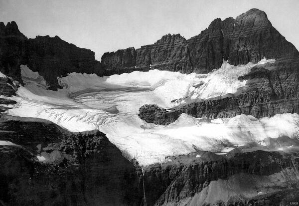
Shepard Glacier, Glacier National Park, Montana - 1913
Shepard Glacier, Glacier National Park, Montana - 1913Well-defined boundaries and crevasses are apparent in this photo of Shepard Glacier when its mass filled the cirque in 1913. (W.C. Alden)
Shepard Glacier, Glacier National Park, Montana - 1913
Shepard Glacier, Glacier National Park, Montana - 1913Well-defined boundaries and crevasses are apparent in this photo of Shepard Glacier when its mass filled the cirque in 1913. (W.C. Alden)

Drought Impacts to Livestock in Somalia
A Food Security Assessment in Somalia found severe impacts on livestock due to drought conditions.
A Food Security Assessment in Somalia found severe impacts on livestock due to drought conditions.

Whooping Crane Chick L2-10
This adolescent chick, hatched and raised at the USGS Patuxent Wildlife Research Center, is one of ten whooping cranes being released in Louisiana in February 2011. It is a milestone for the state and for the birds, which have not lived in the state since the 1950s.
This adolescent chick, hatched and raised at the USGS Patuxent Wildlife Research Center, is one of ten whooping cranes being released in Louisiana in February 2011. It is a milestone for the state and for the birds, which have not lived in the state since the 1950s.

Whooping Crane Chick L7-10
This adolescent chick, hatched and raised at the USGS Patuxent Wildlife Research Center, is one of ten whooping cranes being released in Louisiana in February 2011. It is a milestone for the state and for the birds, which have not lived in the state since the 1950s.
This adolescent chick, hatched and raised at the USGS Patuxent Wildlife Research Center, is one of ten whooping cranes being released in Louisiana in February 2011. It is a milestone for the state and for the birds, which have not lived in the state since the 1950s.

Whooping Crane Chick L10-10
This adolescent chick, hatched and raised at the USGS Patuxent Wildlife Research Center, is one of ten whooping cranes being released in Louisiana in February 2011. It is a milestone for the state and for the birds, which have not lived in the state since the 1950s.
This adolescent chick, hatched and raised at the USGS Patuxent Wildlife Research Center, is one of ten whooping cranes being released in Louisiana in February 2011. It is a milestone for the state and for the birds, which have not lived in the state since the 1950s.

Mixed Birds Fly Over Shoreline
The U.S.

Westhope Gage House
The Westhope, ND gage house along the Souris River.
The Westhope, ND gage house along the Souris River.