
A view of the Grand Canyon, with the Great Unconformity visible. Credit: Alex Demas, USGS.
Images
Images
Filter Total Items: 9454

Colorado River through the Grand Canyon
A view of the Grand Canyon, with the Great Unconformity visible. Credit: Alex Demas, USGS.

Release of Adult Golden Eagle
A USGS biological science technician releases an adult golden eagle (Aquila chrysaetos) near Barrett Reservoir in southern California.
Location: Near Barrett Reservoir, San Diego County, California. Photo provided courtesy of photographer. Contact photographer for use.
A USGS biological science technician releases an adult golden eagle (Aquila chrysaetos) near Barrett Reservoir in southern California.
Location: Near Barrett Reservoir, San Diego County, California. Photo provided courtesy of photographer. Contact photographer for use.

Adule Golden Eagle (Landscape)
A USGS biological science technician holds an adult golden eagle (Aquila chrysaetos) ready for release. The USGS uses solar-powered GPS tags and special 3-D mapping techniques to track the eagles' movements across the landscape.
A USGS biological science technician holds an adult golden eagle (Aquila chrysaetos) ready for release. The USGS uses solar-powered GPS tags and special 3-D mapping techniques to track the eagles' movements across the landscape.

Adule Golden Eagle (Portrait)
A USGS biological science technician holds an adult golden eagle (Aquila chrysaetos) ready for release. The USGS uses solar-powered GPS tags and special 3-D mapping techniques to track the eagles' movements across the landscape.
A USGS biological science technician holds an adult golden eagle (Aquila chrysaetos) ready for release. The USGS uses solar-powered GPS tags and special 3-D mapping techniques to track the eagles' movements across the landscape.

Armenia water work
Field training on well inventory and collection of water-level data at a non-flowing well near Yeghegnavan, Armenia, near the Armenia/Turkey/Iran border. Mt. Ararat is in background.
Field training on well inventory and collection of water-level data at a non-flowing well near Yeghegnavan, Armenia, near the Armenia/Turkey/Iran border. Mt. Ararat is in background.

Water Sampling from Well in Armenia
Mark Anderson, Director of the USGS South Dakota Water Science Center, demonstrates how to collect a stable isotope sample from a flowing well near Sis, Armenia.
Mark Anderson, Director of the USGS South Dakota Water Science Center, demonstrates how to collect a stable isotope sample from a flowing well near Sis, Armenia.

Aquaculture in Armenia
The growth of aquaculture to raise trout, sturgeon and other cold-water fish has increased withdrawals of critical groundwater in the Ararat Basin of Armenia. The USGS is working with partners, including USAID, to develop scientific tools for water-resource managers to understand and predict consequences of management decisions in Armenia.
The growth of aquaculture to raise trout, sturgeon and other cold-water fish has increased withdrawals of critical groundwater in the Ararat Basin of Armenia. The USGS is working with partners, including USAID, to develop scientific tools for water-resource managers to understand and predict consequences of management decisions in Armenia.

Pressure gage water data collection
Field training on how to measure water level using a pressure gage for a flowing well in Sis, Armenia.
Field training on how to measure water level using a pressure gage for a flowing well in Sis, Armenia.

Monarch Male Close-Up
A monarch butterfly (Danaus plexippus) resting and sunning at an overwintering site in the Piedra Herrada Monarch Butterfly Sanctuary in Mexico. This individual is a male, identifiable by the black spot on each hindwing.
A monarch butterfly (Danaus plexippus) resting and sunning at an overwintering site in the Piedra Herrada Monarch Butterfly Sanctuary in Mexico. This individual is a male, identifiable by the black spot on each hindwing.

Monarch Butterflies on Tree
A group of monarch butterflies (Danaus plexippus) covers an oyamel fir tree (Abies religiosa) at an overwintering site in the Piedra Herrada Monarch Butterfly Sanctuary in Mexico.
A group of monarch butterflies (Danaus plexippus) covers an oyamel fir tree (Abies religiosa) at an overwintering site in the Piedra Herrada Monarch Butterfly Sanctuary in Mexico.
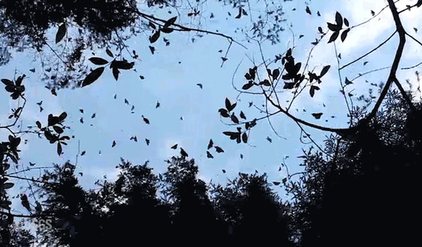
Monarch Butterflies
This animated GIF shows a group of monarch butterflies flying among the oyamel fir tree forest at an overwintering site in the Piedra Herrada Monarch Butterfly Sanctuary, Mexico. Extracted from this original USGS video by Steve Hilburger, USGS.
This animated GIF shows a group of monarch butterflies flying among the oyamel fir tree forest at an overwintering site in the Piedra Herrada Monarch Butterfly Sanctuary, Mexico. Extracted from this original USGS video by Steve Hilburger, USGS.

Honey Bees are Valuable Pollinators
Honey bees play a major role in pollinating the world’s plants, including those we eat regularly. However, land-use changes that decrease flower abundance can affect bee health and pollination services.
Honey bees play a major role in pollinating the world’s plants, including those we eat regularly. However, land-use changes that decrease flower abundance can affect bee health and pollination services.

Unidentified Flock of Birds
Flock of unidentified birds in water with Mangroves at Merritt Island National Wildlife Refuge.
Flock of unidentified birds in water with Mangroves at Merritt Island National Wildlife Refuge.

Rio Grande from New Mexico State Road 359, New Mex.
Rio Grande from New Mexico State Road 359, New Mex.North-oriented view of the Rio Grande from New Mexico State Road 359 near Mesilla, N. Mex., February 11, 2016 (photograph by Nicholas R. Glaser, U.S. Geological Survey).
SIR 2016–5011
Rio Grande from New Mexico State Road 359, New Mex.
Rio Grande from New Mexico State Road 359, New Mex.North-oriented view of the Rio Grande from New Mexico State Road 359 near Mesilla, N. Mex., February 11, 2016 (photograph by Nicholas R. Glaser, U.S. Geological Survey).
SIR 2016–5011

Rio Grande at New Mex. State Road 359
North-oriented view of the Rio Grande at New Mexico State Road 359 near Mesilla, N. Mex., February 11, 2016 (photograph by Nicholas R. Glaser, U.S. Geological Survey).
SIR 2016–5011
North-oriented view of the Rio Grande at New Mexico State Road 359 near Mesilla, N. Mex., February 11, 2016 (photograph by Nicholas R. Glaser, U.S. Geological Survey).
SIR 2016–5011

Hawksbill Sea Turtle Swimming over Elkhorn Coral, St. John, USVI
Hawksbill Sea Turtle Swimming over Elkhorn Coral, St. John, USVIHawksbill sea turtle swimming over elkhorn coral, St. John, U.S. Virgin Islands.
Hawksbill Sea Turtle Swimming over Elkhorn Coral, St. John, USVI
Hawksbill Sea Turtle Swimming over Elkhorn Coral, St. John, USVIHawksbill sea turtle swimming over elkhorn coral, St. John, U.S. Virgin Islands.

Rio Grande, about 1 mile southwest of Montaño Bridge
Rio Grande, about 1 mile southwest of Montaño BridgeUpstream view of the Rio Grande from a location about 1 mile southwest of the Montaño Bridge. Photograph was taken January 24, 2016, by Nathan Myers.
SIR 2016–5021
Rio Grande, about 1 mile southwest of Montaño Bridge
Rio Grande, about 1 mile southwest of Montaño BridgeUpstream view of the Rio Grande from a location about 1 mile southwest of the Montaño Bridge. Photograph was taken January 24, 2016, by Nathan Myers.
SIR 2016–5021

Congressional Staff Tour in the Atchafalaya Basin
USGS scientists Dan Kroes and Charlie Demas took local Congressional staffers into the Atchafalaya Basin to show them the effects of the flooding on the Basin.
USGS scientists Dan Kroes and Charlie Demas took local Congressional staffers into the Atchafalaya Basin to show them the effects of the flooding on the Basin.

Flooded House in the Atchafalaya Basin
In late 2015/early 2016 unusually large rainfall in the Upper Mississippi River Valley led to significant flooding in Arkansas, Illinois, Louisiana, Mississippi, Missouri, and Tennessee. USGS crews responded to the flooding by collecting streamflow and water quality information and providing it to emergency responders.
In late 2015/early 2016 unusually large rainfall in the Upper Mississippi River Valley led to significant flooding in Arkansas, Illinois, Louisiana, Mississippi, Missouri, and Tennessee. USGS crews responded to the flooding by collecting streamflow and water quality information and providing it to emergency responders.