
New Product from the 3D Elevation Program
Seamless 1 Meter Digital Elevation Model (S1M)
Seamless 1 Meter Digital Elevation Model (S1M)
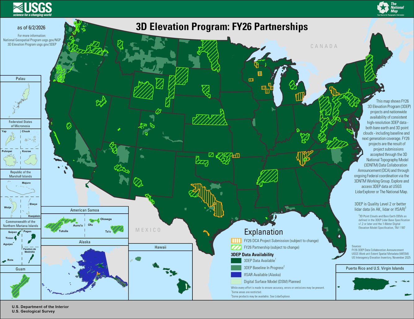
FY26 3D Elevation Program DCA
The 3D National Topography Model Call for Action Part 2: The Next Generation 3D Elevation Program
2025 Post-Wildfire Lidar Data for Los Angeles, CA
3DNTM DCA Projects Web Mapping Application
3D Nation Study - RESULTS
Study documents $13.5 billion of benefits for 1,352 mission critical requirements for topographic and inland, nearshore, and offshore bathymetric 3D elevation data
Study documents $13.5 billion of benefits for 1,352 mission critical requirements for topographic and inland, nearshore, and offshore bathymetric 3D elevation data
3DEP lidar data to improve knowledge of the geologic framework
Data acquisition for parts of Nevada & California
Data acquisition for parts of Nevada & California
Spatial Metadata
The Work unit Extent Spatial Metadata is a good source of information for current lidar data availability and basic information about lidar projects.
The Work unit Extent Spatial Metadata is a good source of information for current lidar data availability and basic information about lidar projects.
3D Elevation Program
The mission of 3DEP is to respond to growing needs for current high-quality topographic data and three-dimensional (3D) representations of the Nation's natural and constructed features.
Data Collaboration Announcement
Data Collaboration Announcement

The DCA provides a mechanism for partnering with the USGS and other Federal Agencies to acquire high-quality 3D Elevation or 3D Hydrography data to provide the Nation with high-resolution topographic products to support a broad array of applications.
About 3DEP Products & Services
About 3DEP Products & Services

All 3DEP products are available free of charge and without use restrictions.
Data Access and Visualization Apps
Data Access and Visualization Apps

A listing of web map services, viewers, applications and tools
Media
Sources/Usage: Public Domain. View Media Details
Media
Sources/Usage: Public Domain. View Media Details
Media
Sources/Usage: Public Domain. View Media Details
News
Partnership Selections for the 2025 3D National Topography Model Data Collaboration Announcement
Partnership Selections for the 2025 3D National Topography Model Data Collaboration Announcement
New 3D Elevation Program Fact Sheet for Massachusetts
New 3D Elevation Program Fact Sheet for Massachusetts
New 3D Elevation Program Fact Sheet for Tennessee
New 3D Elevation Program Fact Sheet for Tennessee
Publications
The 3D Elevation Program—Supporting the economy of Massachusetts The 3D Elevation Program—Supporting the economy of Massachusetts
Introduction Massachusetts extends from the mountains of the Appalachian system in the west of the State to the sandy beaches and rocky shorelines of the Atlantic coast in the east. Inland topographic data support a wide range of important activities, including geologic mapping, transportation planning, forest and wildlife management, quantifying ecological services, water supply...
The 3D Elevation Program—Supporting Tennessee’s economy The 3D Elevation Program—Supporting Tennessee’s economy
Introduction The State of Tennessee has an area of approximately 42,100 square miles and includes six physiographic regions: Blue Ridge, Valley and Ridge, Appalachian Plateaus, Highland Rim, Nashville Basin, and the Gulf Coastal Plains. Up-to-date elevation data support key activities across the State, such as economic development, infrastructure and construction management, agriculture...
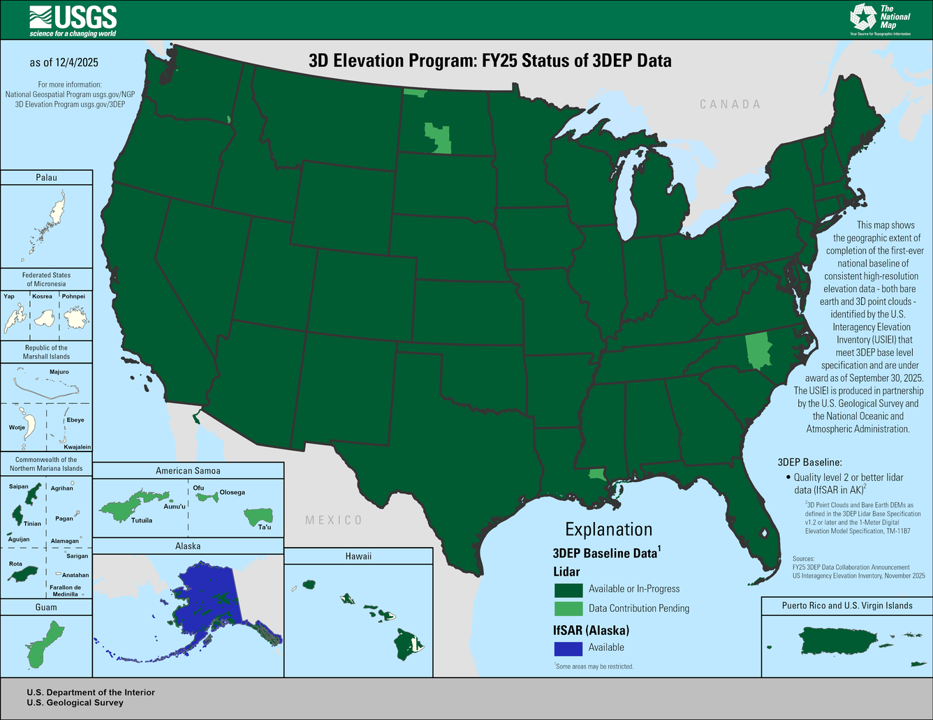
The 3D National Topography Model Call for Action—Part 2: The Next Generation 3D Elevation Program The 3D National Topography Model Call for Action—Part 2: The Next Generation 3D Elevation Program
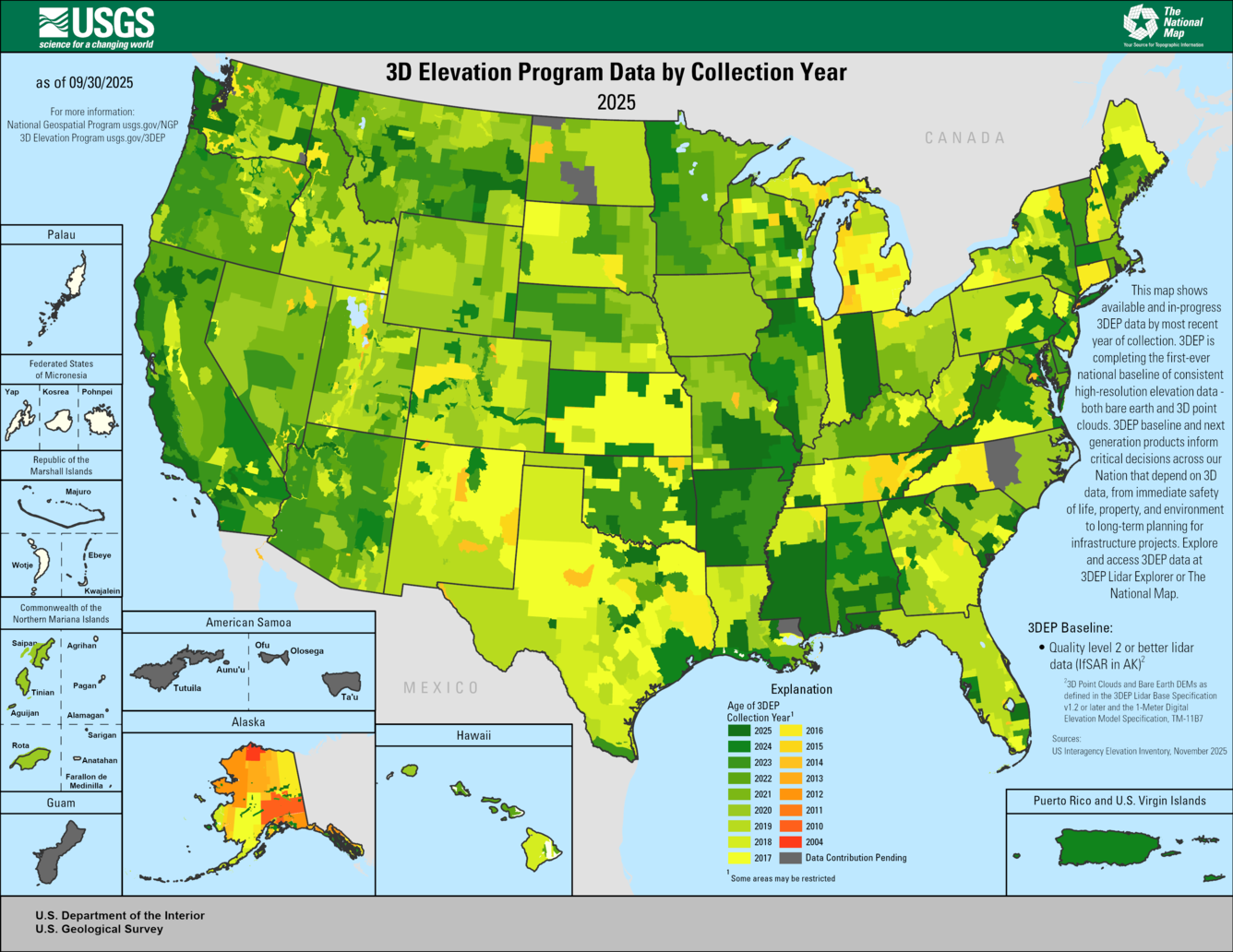
The three-dimensional (3D) National Topography Model initiative to integrate elevation and hydrography data includes the next generation of hydrography data from the 3D Hydrography Program and the next generation of elevation data from the 3D Elevation Program (3DEP). The first-ever collection of light detection and ranging (lidar) data for the nation (IfSAR for Alaska) provides a...
Science

2025 CEGIS Annual Research Meeting
The Center of Excellence for Geospatial Information Science (CEGIS) was proud to host the 2025 CEGIS Annual Research Meeting July 22-24, 2025. The annual research meeting is a special occasion to celebrate our accomplishments, explore ongoing projects, and foster collaboration for future endeavors. This year's gathering featured a broad range of presentations from our researchers and their...

2025 Post-Wildfire Lidar Data for Los Angeles, CA
Following the devastating Los Angeles, California wildfires in January 2025, NV5 (a geospatial, engineering, and consulting company that serves as a prime contractor to the 3D Elevation Program via the USGS Geospatial Products and Services Contracts) acquired high-resolution airborne lidar data for the Palisades and Eaton impact areas. Through its partnership with University of California San...