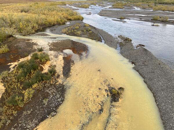
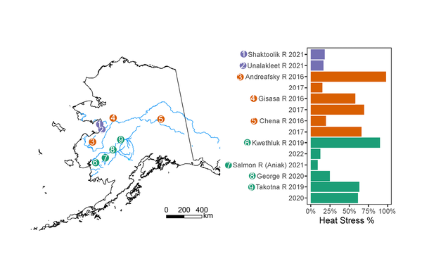
Two cameras were installed in December of 2024 on the Anchor River to monitor flooding associated with river ice. Traditional hydrologic monitoring is often ineffective when rivers freeze and break up and the cameras provide information needed by our partners to verify water levels and issue flood forecasts.
Images
Browse images from a wide range of science topics covered by USGS. All items in this gallery are considered public domain unless otherwise noted.

Two cameras were installed in December of 2024 on the Anchor River to monitor flooding associated with river ice. Traditional hydrologic monitoring is often ineffective when rivers freeze and break up and the cameras provide information needed by our partners to verify water levels and issue flood forecasts.
This map depicts the permafrost zones across Alaska, overlain by project focus areas. The hashed turquoise region represents areas where pingo mapping is being prioritized. The lime green color outlines the 1002 area, where surficial geological maps are being used to generate more reliable predictors for ground ice content.
An IfSAR DEM image of thaw lake basins (right) in an otherwise flat Arctic coastal plains topography. IfSAR data was collected for Alaska between 2012-2020.
An IfSAR DEM image (left) is highlighting the presence of several steep-sided pingos and thaw lake basins. IfSAR data was collected for Alaska between 2012-2020.

This map is showing data contributors and primary sampling methods for Alaska Forage Fish Database (AFFD).
Map of locations within the Alaska Forage Fish Database where forage species were encountered (color). Grey points represent sites where sampling occurred, but the specific forage species was not encountered.
USGS scientist Louis Sass assesses an on-glacier weather station on the Kahiltna Glacier in Denali National Park, Alaska. This weather station is located at Kahiltna Base Camp, where climbers attempting to summit Denali begin their ascent. Sultana (Mt. Foraker) is visible in the background.
USGS uses small uncrewed aerial systems, also known as drones for science, to survey walrus herds and carcasses on remote Alaskan beaches. The USGS visual observer, Christina Ahlstrom, keeps her eyes on the survey drone while the remote pilot prepares it to survey the walrus herd that is visible in the distance behind her on the beach.
Aerial survey drone prepared for flight positioned on the beach near walrus calf carcasses. When sea ice retreats from large regions of the Chukchi Sea large herds of female and young walruses come to shore to rest.
Sign along a wall adjacent to a parking lot in downtown Anchorage warn motorists and passersby about the hazard presented by unreinforced masonry walls.
Streamflow measurement at the U.S. Geological Survey Chester Creek streamgage. U.S. Geological Survey hydrologic technician using an acoustic Doppler current profiler to measure streamflow.
The photo is of two Long-billed Murrelets seen near Grewingk Glacier in Kachemak Bay, Cook Inlet, Alaska. This pair of uncommon visitors was spotted in Kachemak Bay during the annual USGS survey of seabirds and small pelagic fish in Cook Inlet.
A scientist is examining the cable number from a set of legacy borehole sites for permafrost ground temperature monitoring in Utqiagvik, Alaska (part of USGS research at the Naval Arctic Research Laboratory from the 1950s to 1970s).
A scientist is walking by a set of legacy borehole sites for permafrost ground temperature monitoring in Utqiagvik, Alaska (part of USGS research at the Naval Arctic Research Laboratory from the 1950s to 1970s). Some of the wooden housings that covered these boreholes have since toppled over; others are submerged in pools of the thawing landscape.
A scientist is holding the cable top at a recently relocated site for permafrost ground temperature monitoring in Utqiagvik, Alaska (part of USGS research at the Naval Arctic Research Laboratory from the 1950s to 1970s).
USGS is flying drones for science, small uncrewed areal systems (sUAS), to surveys walruses when they rest on shore. The sUAS makes minimal sound due it is broad wing and is flown high above the walrus herds to enables survey data collection with minimal risk to walruses.
Two adult walrus carcasses on the beach observed during the summer after a large group of walruses had rested on shore. USGS is collaborating with the North Slope Borough Department of Wildlife Management to screen walruses for wildlife diseases and algal toxins. The University of Alaska Fairbanks is collaborating with USGS to validate drone survey metho
Orcas (Orcinus orca) of the AD8 pod search for schools of salmon in Amalik Bay. Orca populations have declined significantly since the Exxon Valdez oil spill in 1989. By collecting photos of saddle patches and dorsal fin notches, scientists are able to identify unique individual whales.
Male orca (Orcinus orca) AD37 "Brit" of pod AD8, swims next to a scientific research skiff in Amalik Bay. Orca populations have declined significantly since the Exxon Valdez oil spill in 1989. By collecting photos of saddle patches and dorsal fin notches, scientists are able to identify unique individual whales.
Male orca (Orcinus orca) AD37 "Brit" of pod AD8, swims in front of a scientific research skiff in Amalik Bay. Orca populations have declined significantly since the Exxon Valdez oil spill in 1989. By collecting photos of saddle patches and dorsal fin notches, scientists are able to identify unique individual whales.
A cluster of mussels (Mytilus spp.) and barnacles at one of five rocky intertidal sampling sites in Katmai National Park and Preserve. An annual assessment of mussel size and density allows scientists to quantify change in communities from sheltered rocky shorelines.