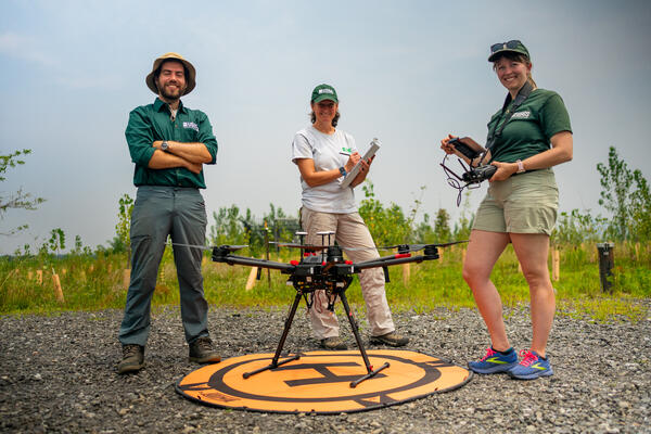
U.S. flag

An official website of the United States government

Multimedia

Images

On a frozen river, one person cuts into ice with chainsaw while another person holds a long pole tool.
Rustin Pare, Technician, uses a chainsaw to acquire ice measurements with Jacob Mavrogeorge on the Monocacy River in Fredrick, Maryland

Rustin Pare, Technician, uses a chainsaw to acquire ice measurements with Jacob Mavrogeorge on the Monocacy River in Fredrick, Maryland.

Winter 2025 Photo Contest Winner: Neel Hodgkinson, USGS at Work category

Rustin Pare, Technician, uses a chainsaw to acquire ice measurements with Jacob Mavrogeorge on the Monocacy River in Fredrick, Maryland.

Winter 2025 Photo Contest Winner: Neel Hodgkinson, USGS at Work category

A hydrologic technician takes streamflow measurements below the ice.
Cattail Creek Ice Measurement

Hydrologic technician Augustine Barquin takes streamflow measurements below the ice at Cattail Creek near Glenwood, MD (01591400).

Photo credit: Brett McFarland

Hydrologic technician Augustine Barquin takes streamflow measurements below the ice at Cattail Creek near Glenwood, MD (01591400).

Photo credit: Brett McFarland

Physical scientist Zach Clifton studies sediment samples in a dark room with red light.
Sediment Lab Low Light

Physical scientist Zach Clifton studies sediment samples in a dark room.

Photo credit: Neel Hodgkinson

Physical scientist Zach Clifton studies sediment samples in a dark room.

Photo credit: Neel Hodgkinson

A gage box adjacent to a stream.
Meetinghouse Branch at Camp Springs

An image of the streamgage at Meetinghouse Branch at Camp Springs, Maryland (01653620).

An image of the streamgage at Meetinghouse Branch at Camp Springs, Maryland (01653620).

A man wearing an orange life jacket walks down a field with fencing on the left and trees on the right.
Tristan Mohs Forest Buffer

Physical Scientist Tristan Mohs walks through a forest buffer area.

Fencing and riparian forest-buffer planting are essential tools for managers and provide numerous benefits to streams.

Physical Scientist Tristan Mohs walks through a forest buffer area.

Fencing and riparian forest-buffer planting are essential tools for managers and provide numerous benefits to streams.

Series of maps showing modeled stream incision levels for 2002 and 2018
Series of maps showing modeled stream incision levels for 2002 and 2018 in Montgomery County, MD

Extent of each study watershed exhibiting characteristics of no incision (blue), moderate incision (orange), and severe incision (red) for the 2002 and 2018 time periods. Boxes A–D on stream networks correspond to photo examples shown below. Photo A taken November 2016, photos B and C taken October 2016, and photo D taken April 2022.

Extent of each study watershed exhibiting characteristics of no incision (blue), moderate incision (orange), and severe incision (red) for the 2002 and 2018 time periods. Boxes A–D on stream networks correspond to photo examples shown below. Photo A taken November 2016, photos B and C taken October 2016, and photo D taken April 2022.

Videos

An autonomous boat in a stream. A cutout of a person with a thumbs up. USGS On the Road - Deploying the Autonomous Boat at Lower Darby Creek
USGS On the Road - Deploying the Autonomous Boat at Lower Darby Creek

Did you know the USGS is involved in understanding how PFAS travel through the environment?

In a dark room, a scientist wearing a red headlamp examines a sediment sample. Text on image: Are you afraid of the dark? USGS On the Road - Sampling in the Dark
USGS On the Road - Sampling in the Dark

Are you afraid of the dark?

Not this scientist. He is using a special technique to examine sediment samples that can help scientists study historical hurricanes.

Are you afraid of the dark?

Not this scientist. He is using a special technique to examine sediment samples that can help scientists study historical hurricanes.

A man walks on a catwalk with turbid waters below. Text on screen: What's in the dam water? USGS On the Road - What's in the Dam Water?
USGS On the Road - What's in the Dam Water?

It’s the final checkpoint…

As the largest river flowing into the nation's largest freshwater estuary, the Susquehanna River plays an important role in the water quality of the Chesapeake Bay.

It’s the final checkpoint…

As the largest river flowing into the nation's largest freshwater estuary, the Susquehanna River plays an important role in the water quality of the Chesapeake Bay.

Text reads: We've been sampling this Chesapeake Bay tributary for over 50 years. Image: Collecting a sample from the river. USGS On the Road — Choptank River Water Quality Sampling
USGS On the Road — Choptank River Water Quality Sampling

On a fair sunny day in March, hydrologic technician Michael Brownley makes his way up the metal rung ladder to a platform. From there he beards a cableway, no bigger than a twin-sized bed. Luckily, he’s the only one aboard the cableway, space is tight as it is.

On a fair sunny day in March, hydrologic technician Michael Brownley makes his way up the metal rung ladder to a platform. From there he beards a cableway, no bigger than a twin-sized bed. Luckily, he’s the only one aboard the cableway, space is tight as it is.

A hydrologic technician stands in a stream with a sampling bottle. Text on screen: How do we sample water-quality? USGS On the Road - Measuring Water Quality at Plumtree
USGS On the Road - Measuring Water Quality at Plumtree

As a USGS hydrologic technician Kelly McVicker explains, we collect water-quality samples with an attention to detail.

Why care about water quality? Because it holds the clues to the health of the stream or river.

As a USGS hydrologic technician Kelly McVicker explains, we collect water-quality samples with an attention to detail.

Why care about water quality? Because it holds the clues to the health of the stream or river.

Video thumbnail with text that reads "Stream Team! Looking at stream habitats" with three people posing or photos. USGS On the Road - Habitat Assessment at Red Run
USGS On the Road - Habitat Assessment at Red Run

Our scientists are keen on understanding the impact that urban and suburban developments can have on stream habitats.

Our scientists are keen on understanding the impact that urban and suburban developments can have on stream habitats.

Was this page helpful?