U.S. flag

An official website of the United States government

Multimedia

This gallery provides public domain images and videos produced by Oklahoma-Texas Water Science Center.

Images

Color photo of Zulimar smiling. She has long brown straight hair and is wearing a marroon shirt with city buildings in the background.
ZulimarLucena.jpg
ZulimarLucena.jpg
ZulimarLucena.jpg

head shot of Zuli Lucena for staff profile, she is supervisory hydrologist in the Conroe TX office. 

head shot of Zuli Lucena for staff profile, she is supervisory hydrologist in the Conroe TX office. 

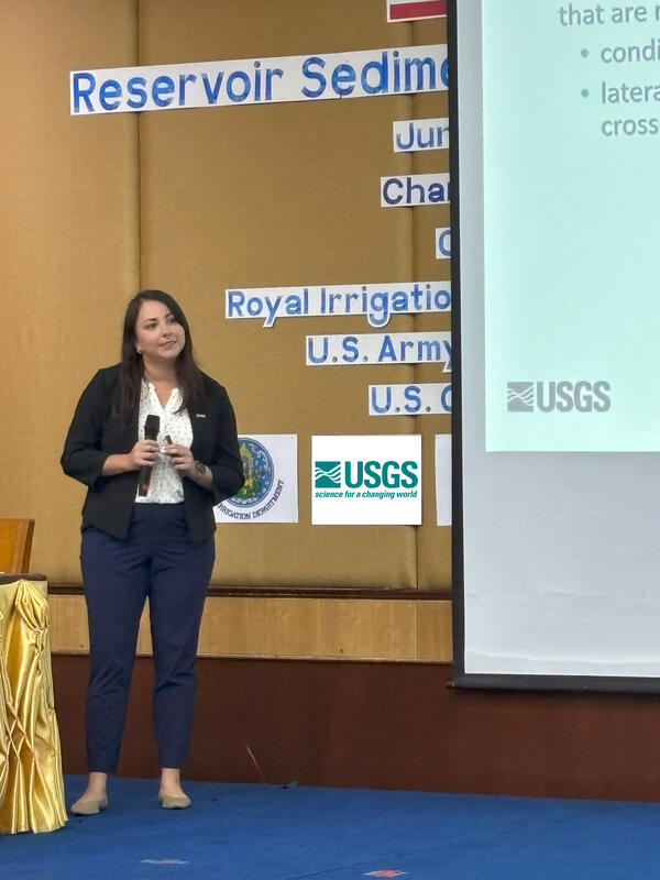
Zulimar Lucena leads a water quality workshop for the Thailand Royal Irrigation Department

Zulimar (Zuli) Lucena (Hydrologist, Oklahoma - Texas Water Science Center) leads a water quality workshop for the Thailand Royal Irrigation Department on 16 June 2025. The workshop was conducted in Chiang Mai, Thailand.

A USGS water expert stands on a bridge measuring floodwaters below, with bright orange specialized monitoring equipment float
USGS water expert measures floodwaters off of I-35 near Leon Creek, Texas

USGS water expert Rogelio Hernandez measures floodwaters off of I-35 near Leon Creek in Texas on June 12, 2025, using specialized monitoring equipment to collect data critical for public safety. 

A water specialist stands on a bridge holding a line that controls orange floating water monitoring equipment in the fast-mov
USGS water specialist measures floodwaters near Groesbeck, Texas

USGS water specialist Dwight Sparks measures floodwaters from County Road 402 bridge over the Navasota River near Groesbeck, Texas on June 12, 2025. 

A water specialist measures floodwaters from a bridge while a peacock walks along the bridge railing nearby.
USGS water specialist is joined by feathered company while measuring floodwaters near Groesbeck, Texas

Videos

Surveying Contracted-Opening Indirect Measurements

This video goes into detail about surveying high-water marks, various aspects of bridges, and cross sections for the contracted-opening method. 
 

This video goes into detail about surveying high-water marks, various aspects of bridges, and cross sections for the contracted-opening method. 
 

Requirements for the Contracted-Opening Method

This video discusses the general requirements that will be needed to accomplish a contracted-opening indirect discharge measurement. Approach section, contracted section, and necessary high-water mark locations are described along with scenarios where the method will not be successful. 
 

This video discusses the general requirements that will be needed to accomplish a contracted-opening indirect discharge measurement. Approach section, contracted section, and necessary high-water mark locations are described along with scenarios where the method will not be successful. 
 

Welcome to the USGS GeoLog Locator

Welcome to the USGS GeoLog Locator, an online tool for viewing and downloading digital borehole geophysical logs. These borehole logs are used to answer scientific questions about things like groundwater availability, geologic structure of the Earth, and certain characteristics of the structure of the soil and rock formations.

Welcome to the USGS GeoLog Locator, an online tool for viewing and downloading digital borehole geophysical logs. These borehole logs are used to answer scientific questions about things like groundwater availability, geologic structure of the Earth, and certain characteristics of the structure of the soil and rock formations.

Awareness: USGS "Water-on-the-Go" Mobile App (Texas)

The USGS Texas Water Science Center has developed a new mobile application called “Water On-the-Go” that gives people easy access to current conditions in streams across Texas. The information reflects what is happening in streams near you at that very moment.

The USGS Texas Water Science Center has developed a new mobile application called “Water On-the-Go” that gives people easy access to current conditions in streams across Texas. The information reflects what is happening in streams near you at that very moment.

Be Water Aware: USGS "Water-on-the-Go" Mobile Application

The USGS Texas Water Science Center has developed a new mobile application called “Water On-the-Go” that gives people easy access to current conditions in streams across Texas. The information reflects what is happening in streams near you at that very moment.

The USGS Texas Water Science Center has developed a new mobile application called “Water On-the-Go” that gives people easy access to current conditions in streams across Texas. The information reflects what is happening in streams near you at that very moment.

Texas Flood Surveys
Texas Flood Surveys
Texas Flood Surveys

Hydrologists from Arizona aid the Texas Water Science Center in gathering measurements and other information after the catastrophic Blanco River flooding event that swept Austin, Texas.

Hydrologists from Arizona aid the Texas Water Science Center in gathering measurements and other information after the catastrophic Blanco River flooding event that swept Austin, Texas.

Webcams

Current view from Trinity River webcam
Trinity River at Dallas,TX

USGS Oklahoma-Texas Water Science Center gaging station camera. USGS Gaging Station 08057000 

Current view from Medina Lake webcam
Medina Lake near San Antonio, TX
Current view from Marys Creek webcam
Marys Creek at Benbrook, TX

USGS Oklahoma-Texas Water Science Center gaging station camera. USGS Gaging Station 08047050 

Was this page helpful?