
Hydrologic Technician, Will Ault, examines a water quality sensor in the Klamath River during a routine inspection.
Multimedia
Photos, Videos, and Interviews
We love to share our science
We love to share our science
People are Listening to Science
See what we are saying
See what we are saying
Multimedia products are an important way to distribute information to the public. The Oregon Water Science center continues to produce a variety of outreach materials including audio broadcasts, video podcasts, and online videos. Search below to see what we have been up to.
Images
Klamath River water quality site inspection
Hydrologic Technician, Will Ault, examines a water quality sensor in the Klamath River during a routine inspection.
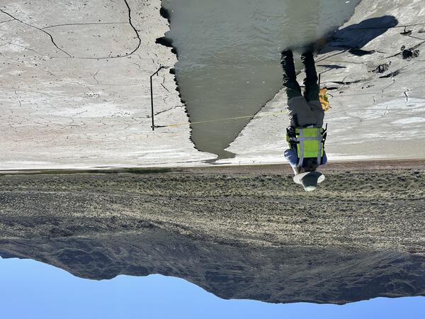
Measuring the Chewaucan River
Klamath Falls Field Office Hydrologic Technician collects a streamflow measurement on the Chewaucan River at Mouth near Valley Falls, OR (10387110). The Chewaucan River flows into Lake Abert, OR.
Klamath Falls Field Office Hydrologic Technician collects a streamflow measurement on the Chewaucan River at Mouth near Valley Falls, OR (10387110). The Chewaucan River flows into Lake Abert, OR.
Chewaucan River field work
Pulling measurement equipment through shallow waters on the banks of the Chewaucan River.
Pulling measurement equipment through shallow waters on the banks of the Chewaucan River.
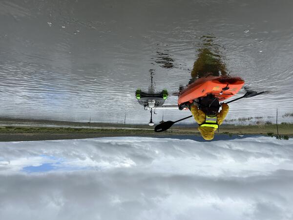
Lake Abert inflow measurement
Measuring a shallow spring fed channel at Lake Abert, Oregon. Lake Abert is one of the 20 plus terminal lakes identified by USGS partners as priority ecosystems for study by the Saline Lakes Ecosystems IWAA.
Measuring a shallow spring fed channel at Lake Abert, Oregon. Lake Abert is one of the 20 plus terminal lakes identified by USGS partners as priority ecosystems for study by the Saline Lakes Ecosystems IWAA.
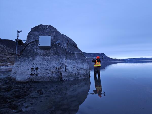
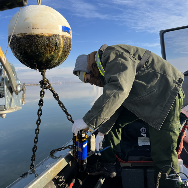
Lake Abert installation
Hydrologic Technician, Ali Moss, installs a radar unit on a large boulder in the shallow water of Lake Abert, OR. The radar unit records the water level in near real-time at this saline lake.
Hydrologic Technician, Ali Moss, installs a radar unit on a large boulder in the shallow water of Lake Abert, OR. The radar unit records the water level in near real-time at this saline lake.
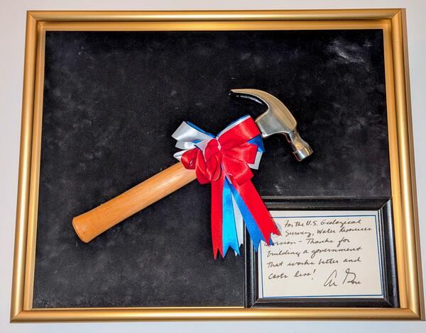
USGS Oregon District Hammer Award
In 1996 the USGS Water Resources Division (now called Water Mission Area) received Vice President Gore's Hammer Award. It was presented by Assistant Secretary for Water and Science, Patricia Beneke, at the Carnegie Center in Oregon City, Oregon, with Dennis Lynch, District Chief, Oregon, accepting on behalf of the Division.
In 1996 the USGS Water Resources Division (now called Water Mission Area) received Vice President Gore's Hammer Award. It was presented by Assistant Secretary for Water and Science, Patricia Beneke, at the Carnegie Center in Oregon City, Oregon, with Dennis Lynch, District Chief, Oregon, accepting on behalf of the Division.
Videos

Salmon swim near Clackamas River at Big Bottom streamgage
Salmon swim near Clackamas River at Big Bottom streamgageThis salmon swam more than 175 river miles and passed three dams to reach a pool near our monitoring station, USGS Clackamas River at Big Bottom (#14208000).
Salmon swim near Clackamas River at Big Bottom streamgage
Salmon swim near Clackamas River at Big Bottom streamgageThis salmon swam more than 175 river miles and passed three dams to reach a pool near our monitoring station, USGS Clackamas River at Big Bottom (#14208000).

Cableway measurement of high flow at Cow Creek near Riddle, Oregon
Cableway measurement of high flow at Cow Creek near Riddle, OregonHydrologic technicians make streamflow and other measurements from cableways using a variety of equipment. In this clip, a high flow measurement is taken by towing acoustic sensors across the channel from a cable car.

Saline Lake Ecosystems IWAA Spring Seminar: Project Updates and 2025 Field Season Plans
Saline Lake Ecosystems IWAA Spring Seminar: Project Updates and 2025 Field Season PlansThis video presents the Spring 2025 Saline Lake Ecosystems Integrated Water Availability Assessment Spring Seminar by the U.S. Geological Survey (USGS). Hosted by Allison Shipp, the seminar provides updates on how hydroclimatic changes and water management affect terminal lake ecosystems and waterbird populations.

Saline Lakes IWAA Fall 2024 Webinar Series: Satellite Observations of Lake Surface Water Dynamics
Saline Lakes IWAA Fall 2024 Webinar Series: Satellite Observations of Lake Surface Water DynamicsThe sixth and final webinar in the Saline Lakes Ecosystems IWAA Fall 2024 Webinar Series is on satellite observations of lake surface water dynamics. John W. Jones of the USGS Hydrologic Remote Sensing Branch introduces the surface water and wetland remote sensing component of the Integrated Water Availability Assessment.
By
Ecosystems Mission Area, Water Resources Mission Area, Species Management Research Program, Water Availability and Use Science Program, Forest and Rangeland Ecosystem Science Center, Fort Collins Science Center, Nevada Water Science Center, Oregon Water Science Center, Utah Water Science Center, Western Ecological Research Center (WERC), Saline Lake Ecosystems Integrated Water Availability Assessment

Saline Lakes IWAA Fall 2024 Webinar Series: Waterbird Prey Availability
Saline Lakes IWAA Fall 2024 Webinar Series: Waterbird Prey AvailabilityThe fifth webinar in the Saline Lakes Ecosystems IWAA Fall 2024 Webinar Series is on waterbird prey availability in Great Basin terminal lakes.
By
Ecosystems Mission Area, Water Resources Mission Area, Species Management Research Program, Water Availability and Use Science Program, Forest and Rangeland Ecosystem Science Center, Fort Collins Science Center, Nevada Water Science Center, Oregon Water Science Center, Utah Water Science Center, Western Ecological Research Center (WERC), Saline Lake Ecosystems Integrated Water Availability Assessment

Saline Lakes Ecosystems IWAA Fall 2024 Webinar Series: Bird Movements
Saline Lakes Ecosystems IWAA Fall 2024 Webinar Series: Bird MovementsThe fourth webinar in the Saline Lakes Ecosystems IWAA Fall 2024 Webinar Series is on movement of bird species associated with Great Basin terminal lake ecosystems. Cory Overton of the Western Ecological Research Center gives an overview of the USGS bird movement monitoring strategy and presents results from the 2024 field season.
By
Ecosystems Mission Area, Water Resources Mission Area, Species Management Research Program, Water Availability and Use Science Program, Forest and Rangeland Ecosystem Science Center, Fort Collins Science Center, Nevada Water Science Center, Oregon Water Science Center, Utah Water Science Center, Western Ecological Research Center (WERC), Saline Lake Ecosystems Integrated Water Availability Assessment
Audio

Groundwater 101
In this episode we explore how vital groundwater is as a natural resource and discuss what impact a changing climate and human consumption has on groundwater supplies. Join us, as we sit down with USGS Groundwater Specialist Marshall Gannett to get a primer on the role groundwater plays in our daily lives, today on the Oregon Science Podcast.
In this episode we explore how vital groundwater is as a natural resource and discuss what impact a changing climate and human consumption has on groundwater supplies. Join us, as we sit down with USGS Groundwater Specialist Marshall Gannett to get a primer on the role groundwater plays in our daily lives, today on the Oregon Science Podcast.
Oregon Songbirds: Singing for Their Supper in Evergreen Forests
Oregon Songbirds: Singing for Their Supper in Evergreen ForestsIn this episode we sit down with USGS wildlife biologist Joan Hagar and discuss her recent study on songbirds in the Pacific Northwest. New research indicates a possible relationship between reductions in the abundance of some species of songbird and reductions in the amount of deciduous trees in evergreen forests.
Clearing up Muddy Waters
For this month’s episode we discuss the water-quality parameter turbidity. More than just a way to measure dirty water, turbidity can serve as a useful indicator of the ecological health of a watershed.
For this month’s episode we discuss the water-quality parameter turbidity. More than just a way to measure dirty water, turbidity can serve as a useful indicator of the ecological health of a watershed.
3-D Geologic Model of Columbia Plateau Aquifer System
3-D Geologic Model of Columbia Plateau Aquifer SystemIn this month’s episode we discuss how 3-D modeling is used to examine groundwater in the Columbia Plateau. USGS hydrologist Erick Burns describes how his team modeled the 53,000 mi2 plateau, how this information is currently used, and what implications it has for the future.
Light Detection and Ranging, or LiDAR
This month's episode focuses on one of the most useful geographic tools scientists have for studying our natural world: Light Detection and Ranging, or LiDAR. LiDAR is a powerful data collection technique that can be used to map surface features, even those hidden beneath the dense canopy of Pacific Northwest forests.
This month's episode focuses on one of the most useful geographic tools scientists have for studying our natural world: Light Detection and Ranging, or LiDAR. LiDAR is a powerful data collection technique that can be used to map surface features, even those hidden beneath the dense canopy of Pacific Northwest forests.
Unearthing the Secrets Beneath the Forest Floor
There is a black box hidden beneath the forests of the Pacific Northwest, guarding the secrets to why the trees grow so large! The black box is soil, which harbors immense biological diversity and controls the release of water and nutrients that support the life above ground.
There is a black box hidden beneath the forests of the Pacific Northwest, guarding the secrets to why the trees grow so large! The black box is soil, which harbors immense biological diversity and controls the release of water and nutrients that support the life above ground.