
Pennsylvania Water Science Center
Susquehanna River Story - Water Quality
USGS Releases Products Documenting Effects of Hurricane Ida
Nitrogen in the Chesapeake Bay Watershed - A Century of Change
Nitrogen in the Chesapeake Bay Watershed - A Century of Change
USGS Collects High-Quality Water-Resources Data for Pennsylvania
Streamflow, groundwater levels, water quality, precipitation, water use, and other related data, both real time and historic
Streamflow, groundwater levels, water quality, precipitation, water use, and other related data, both real time and historic
Hydrologic Studies, Research, and Tools for Pennsylvania
Water availability, groundwater contamination, nutrient loading in streams, effects of land use on water quality, and other water-resource topics
Water availability, groundwater contamination, nutrient loading in streams, effects of land use on water quality, and other water-resource topics
Pennsylvania Water Science Center
We work in cooperation with federal, state, and local agencies to collect scientific data and conduct scientific studies of the source, quantity, quality, ecology, and use of Pennsylvania's water resources.
News
Pennsylvania Waters - Winter 2026 - Issue 15
Pennsylvania Waters - Winter 2026 - Issue 15
Drought Watch Expanded to 40 Pennsylvania Counties
Drought Watch Expanded to 40 Pennsylvania Counties
Pennsylvania Waters - Spring 2025 - Issue 14
Pennsylvania Waters - Spring 2025 - Issue 14
Publications
Invasive predatory fish occupies highest trophic position leading to expansion of isotopic niches in a riverine food web Invasive predatory fish occupies highest trophic position leading to expansion of isotopic niches in a riverine food web
Invasive species are drivers of ecological change with the potential to reshape the structure and function of terrestrial and aquatic ecosystems. The invasive flathead catfish (Pylodictis olivaris) is an opportunistic predator that has established a rapidly growing population in the Susquehanna River, Pennsylvania, USA, since they were first detected in 2002. Although the predatory...
Projecting stream water quality using Weighted Regression on Time, Discharge, and Season (WRTDS): An example with drought conditions in the Delaware River Basin Projecting stream water quality using Weighted Regression on Time, Discharge, and Season (WRTDS): An example with drought conditions in the Delaware River Basin
Future water availability depends on understanding the responses of constituent concentrations to hydrologic change. Projecting future water quality remains a methodological challenge, particularly when using discrete observations with limited temporal resolution. This study introduces Weighted Regression on Time, Discharge, and Season for Projection (WRTDS-P), a novel, computationally...
Regional high-frequency monitoring revealed chloride concentrations in exceedance of ecological benchmarks in urban streams across the Delaware River Basin, USA Regional high-frequency monitoring revealed chloride concentrations in exceedance of ecological benchmarks in urban streams across the Delaware River Basin, USA
Rising chloride concentrations pose critical risks to freshwater stream ecosystems in temperate regions like the Delaware River Basin (DRB), USA, where winter deicer applications (i.e., road salt) are common. Increasing chloride concentrations have been documented in the region, but the extent to which chloride exceeds regulatory benchmarks remains unclear because detection of...
Science

Contaminants in groundwater near former Navy bases in southeastern Pennsylvania
USGS has investigated groundwater flow and contaminant transport in the vicinity of former Navy bases in Bucks and Montgomery Counties, southeastern Pennsylvania, in cooperation with the U.S. Navy. Additional cooperative support for these investigations has been provided by the U.S. Environmental Protection Agency, Pennsylvania Department of Environmental Protection, Bucks and Montgomery counties...

Pennsylvania and the Delaware River Basin
In Pennsylvania, the USGS's water-resources roots date back to the late 1800's, with the initiation of streamflow gaging on the Delaware and Susquehanna Rivers and assessments of groundwater resources near Philadelphia. The USGS Pennsylvania Water Science Center continues to provide scientific information about the water resources of the Delaware River Basin, in cooperation with regional and local...
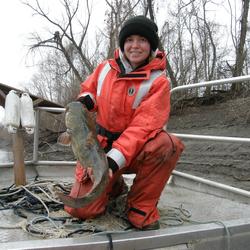
Invasive flathead catfish now top predators in Susquehanna River in Pennsylvania
New study suggests that smallmouth bass and channel catfish are changing what they eat to avoid having to compete with or being eaten by the invader