U.S. flag

An official website of the United States government

Plants

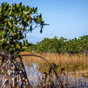
Where would we be without plants? They are the basis of the food chain and producers of oxygen – and so much more. From the marsh grasses to the mangroves to the bald cypress trees to the green algae to the sargassum and seagrass, getting to the root of the biology and ecology of plants is a critical component of WARC’s research.

Filter Total Items: 16

Engaging Indigenous Communities to Co-Design a Web Application to Protect Everglades Tree Islands

The USGS collaborated with the Miccosukee and Seminole Tribes to co-design a dashboard mock-up for a real-time web application that monitors tree island health in the Everglades.
Engaging Indigenous Communities to Co-Design a Web Application to Protect Everglades Tree Islands

Engaging Indigenous Communities to Co-Design a Web Application to Protect Everglades Tree Islands

The USGS collaborated with the Miccosukee and Seminole Tribes to co-design a dashboard mock-up for a real-time web application that monitors tree island health in the Everglades.
Learn More

Climate Change Effects on Coastal Marsh Foundation Species

Mangrove forests have migrated inland over the past few decades at many locations along the northern Gulf coast. This expansion has been attributed to factors associated with climate change, such as increased salinity resulting from sea-level rise and longer intervals between winter freezes, which can kill cold-intolerant mangrove species.
Climate Change Effects on Coastal Marsh Foundation Species

Climate Change Effects on Coastal Marsh Foundation Species

Mangrove forests have migrated inland over the past few decades at many locations along the northern Gulf coast. This expansion has been attributed to factors associated with climate change, such as increased salinity resulting from sea-level rise and longer intervals between winter freezes, which can kill cold-intolerant mangrove species.
Learn More

Seagrass Beds and Manatee Foraging Areas in the Ten Thousand Islands: Mapping and Characterizing by Incorporating Manatee GPS Tracking Data and Habitat Information

Turbid water conditions make the delineation and characterization of benthic habitats difficult by traditional in situ and remote sensing methods. Consequently, only a small fraction of this valuable resource has been mapped or characterized.
Seagrass Beds and Manatee Foraging Areas in the Ten Thousand Islands: Mapping and Characterizing by Incorporating Manatee GPS Tracking Data and Habitat Information

Seagrass Beds and Manatee Foraging Areas in the Ten Thousand Islands: Mapping and Characterizing by Incorporating Manatee GPS Tracking Data and Habitat Information

Turbid water conditions make the delineation and characterization of benthic habitats difficult by traditional in situ and remote sensing methods. Consequently, only a small fraction of this valuable resource has been mapped or characterized.
Learn More

Purple Loosestrife in Louisiana: A Call for Citizen Scientists

Join USGS in helping to prevent the spread of the invasive purple loosestrife in Louisiana.
Purple Loosestrife in Louisiana: A Call for Citizen Scientists

Purple Loosestrife in Louisiana: A Call for Citizen Scientists

Join USGS in helping to prevent the spread of the invasive purple loosestrife in Louisiana.
Learn More

Across Trophic Level System Simulation (ATLSS) Program for the Greater Everglades

Goals of the ATLSS Program are to help achieve a better understanding of components of the Everglades ecosystem, to provide an integrative tool for empirical studies, and to apply these tools to an adaptive management framework.
Across Trophic Level System Simulation (ATLSS) Program for the Greater Everglades

Across Trophic Level System Simulation (ATLSS) Program for the Greater Everglades

Goals of the ATLSS Program are to help achieve a better understanding of components of the Everglades ecosystem, to provide an integrative tool for empirical studies, and to apply these tools to an adaptive management framework.
Learn More

Carbon and Water Budgeting Along Upper Estuaries: Developing Linkages to Environmental Change

WARC Researchers are studying carbon, water, and nutrient cycling in upper estuarine wetlands.
Carbon and Water Budgeting Along Upper Estuaries: Developing Linkages to Environmental Change

Carbon and Water Budgeting Along Upper Estuaries: Developing Linkages to Environmental Change

WARC Researchers are studying carbon, water, and nutrient cycling in upper estuarine wetlands.
Learn More

Assessing Environmental Stress in Mature Mangrove Stands: Linkages to Nutrient Loading

WARC Researchers are comparing tree and root growth, soil CO2 flux, and surface elevation change between fertilized and unfertilized mangrove forests to assess the potential impact of increased nutrient loading and to help rate mangrove stand vulnerability.
Assessing Environmental Stress in Mature Mangrove Stands: Linkages to Nutrient Loading

Assessing Environmental Stress in Mature Mangrove Stands: Linkages to Nutrient Loading

WARC Researchers are comparing tree and root growth, soil CO2 flux, and surface elevation change between fertilized and unfertilized mangrove forests to assess the potential impact of increased nutrient loading and to help rate mangrove stand vulnerability.
Learn More

Wetland Carbon Working Group: Improving Methodologies and Estimates of Carbon and Greenhouse Gas Flux in Wetlands

WARC researchers are working to quantify the impacts of future climate and land use/land cover change on greenhouse gas emissions and reductions.
Wetland Carbon Working Group: Improving Methodologies and Estimates of Carbon and Greenhouse Gas Flux in Wetlands

Wetland Carbon Working Group: Improving Methodologies and Estimates of Carbon and Greenhouse Gas Flux in Wetlands

WARC researchers are working to quantify the impacts of future climate and land use/land cover change on greenhouse gas emissions and reductions.
Learn More

Impacts of coastal and watershed changes on upper estuaries: causes and implications of wetland ecosystem transitions along the US Atlantic and Gulf Coasts

Estuaries and their surrounding wetlands are coastal transition zones where freshwater rivers meet tidal seawater. As sea levels rise, tidal forces move saltier water farther upstream, extending into freshwater wetland areas. Human changes to the surrounding landscape may amplify the effects of this tidal extension, impacting the resiliency and function of the upper estuarine wetlands. One visible...
Impacts of coastal and watershed changes on upper estuaries: causes and implications of wetland ecosystem transitions along the US Atlantic and Gulf Coasts

Impacts of coastal and watershed changes on upper estuaries: causes and implications of wetland ecosystem transitions along the US Atlantic and Gulf Coasts

Estuaries and their surrounding wetlands are coastal transition zones where freshwater rivers meet tidal seawater. As sea levels rise, tidal forces move saltier water farther upstream, extending into freshwater wetland areas. Human changes to the surrounding landscape may amplify the effects of this tidal extension, impacting the resiliency and function of the upper estuarine wetlands. One visible...
Learn More

Using Unmanned Aerial Systems (UAS) Capabilities to Help Identify Giant Salvinia (Salvinia molesta) and the effects of Salvinia weevil (Cyrtogagous salviniae)

USGS is collecting remotely sensed data to classify Salvinia molesta, a non-native aquatic species that reduces light and oxygen levels in water, making it unsuitable for fish and other aquatic plant life.
Using Unmanned Aerial Systems (UAS) Capabilities to Help Identify Giant Salvinia (Salvinia molesta) and the effects of Salvinia weevil (Cyrtogagous salviniae)

Using Unmanned Aerial Systems (UAS) Capabilities to Help Identify Giant Salvinia (Salvinia molesta) and the effects of Salvinia weevil (Cyrtogagous salviniae)

USGS is collecting remotely sensed data to classify Salvinia molesta, a non-native aquatic species that reduces light and oxygen levels in water, making it unsuitable for fish and other aquatic plant life.
Learn More

Identification of Hydrologic Controls on Coastal Spartina patens Marshes and Optimal Hydrological Conditions for Sustainable Mottled Duck Habitat

Mottled ducks rely on the coastal marshes of the Texas Chenier Plain, which are considered among the most critically endangered habitats in the United States. USGS scientists are evaluating what might be contributing to the degradation of high-quality mottled duck habitat to better understand the causes of habitat loss and subsequently mitigate those losses.
Identification of Hydrologic Controls on Coastal Spartina patens Marshes and Optimal Hydrological Conditions for Sustainable Mottled Duck Habitat

Identification of Hydrologic Controls on Coastal Spartina patens Marshes and Optimal Hydrological Conditions for Sustainable Mottled Duck Habitat

Mottled ducks rely on the coastal marshes of the Texas Chenier Plain, which are considered among the most critically endangered habitats in the United States. USGS scientists are evaluating what might be contributing to the degradation of high-quality mottled duck habitat to better understand the causes of habitat loss and subsequently mitigate those losses.
Learn More

The Nonindigenous Aquatic Species Alert Risk Mapper (ARM)

The Nonindigenous Aquatic Species (NAS) program has developed a new tool, the NAS Alert Risk Mapper (ARM), to characterize waterbodies in the conterminous U.S. and Hawaii at potential risk of invasion from a new nonindigenous species sighting.
The Nonindigenous Aquatic Species Alert Risk Mapper (ARM)

The Nonindigenous Aquatic Species Alert Risk Mapper (ARM)

The Nonindigenous Aquatic Species (NAS) program has developed a new tool, the NAS Alert Risk Mapper (ARM), to characterize waterbodies in the conterminous U.S. and Hawaii at potential risk of invasion from a new nonindigenous species sighting.
Learn More
Was this page helpful?