Intro
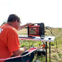
Jason is a hydrologist with the USGS New York Water Science Center, Coram Program Office. Jason graduated from Dowling College in 2010 with a Bachelor’s Degree in Earth Science. During his undergraduate studies, Jason gravitated towards learning more about both hydrology and geology. He also showed interest in Geographic Information Systems (GIS), using the Arc software. A student internship / employment opportunity with the USGS confirmed his passion for learning more about these areas in science. Jason has since then graduated from Stony Brook University with a Master's Degree in Hydrogeology. He is proficient in GIS, and recently developed the skills to write HTML and CSS code. He has contributed towards a number of different projects while using these skills.
Science and Products
Simulation of Contributing Areas to Selected Public Water-Supply Wellfields in the Valley-Fill Aquifers of New York State
Geospatial Dataset of Water-Table and Potentiometric-Surface Altitudes in the Upper Glacial, Magothy, and Lloyd Aquifers of Long Island, New York, March–April 2006
Geospatial Dataset of Water-Table and Potentiometric-Surface Altitudes in the Upper Glacial, Magothy, and Lloyd Aquifers of Long Island, New York, April-May 2010
Horizontal-to-Vertical Spectral Ratio Soundings and Depth-to-Bedrock Data for New York City and Long Island, NY
Geospatial Data for Bedrock Elevation and Overburden Thickness Maps of the Five Boroughs, New York City, New York
Geospatial Datasets of Water Surface Elevation and Water Depth in New York City, NY Associated with the Remnants of Hurricane Ida – September 1, 2021
High-Water Marks in the Five Boroughs of New York City from Flash Flooding Caused by the Remnants of Hurricane Ida, September 1, 2021
Soil-water-balance model archive for Long Island, NY, 1900-2019
Soil-water-balance groundwater recharge model results for Long Island, NY, 1900-2019
Interpolated hydrogeologic framework and digitized datasets for upstate New York study areas
Bed material transport data in the upper Esopus Creek watershed, Ulster and Greene Counties, NY, 2017-2020
Aquifer texture data describing the Long Island aquifer system
Flood inundation map geospatial datasets for Lake Ontario, New York
Water-table and potentiometric-surface altitudes in the upper glacial, Magothy, and Lloyd aquifers of Long Island, New York, April–May 2016
Water-table and potentiometric-surface altitudes in the Upper Glacial, Magothy, and Lloyd aquifers of Long Island, New York, April-May 2013
Bedrock-surface elevation and overburden thickness maps of the five boroughs, New York City, New York
Application of a soil-water-balance model to estimate annual groundwater recharge for Long Island, New York, 1900–2019
Areas contributing recharge to priority wells in valley-fill aquifers in the Neversink River and Rondout Creek drainage basins, New York
Data sources and methods for digital mapping of eight valley-fill aquifer systems in upstate New York
Areas contributing recharge to selected production wells in unconfined and confined glacial valley-fill aquifers in Chenango River Basin, New York
Bed-material transport in the upper Esopus Creek watershed, Ulster and Greene Counties, New York, 2017–20
Trends in precipitation chemistry across the U.S. 1985–2017: Quantifying the benefits from 30 years of Clean Air Act amendment regulation
Simulation of groundwater flow in the regional aquifer system on Long Island, New York, for pumping and recharge conditions in 2005–15
Aquifer transmissivity in Nassau, Queens, and Kings Counties, New York, estimated from specific-capacity tests at production wells
Distribution of selected hydrogeologic characteristics of the upper glacial and Magothy aquifers, Long Island, New York
Hydrologic conditions and simulation of groundwater and surface water in the Great Dismal Swamp of Virginia and North Carolina
Long Island South Shore Estuary Reserve Coordinated Water Resources Monitoring Strategy
Science and Products
- Science
Simulation of Contributing Areas to Selected Public Water-Supply Wellfields in the Valley-Fill Aquifers of New York State
Background For effective wellhead protection, the area where water carrying potential contaminants can enter the groundwater system and flow to the supply well must first be defined, and then best management practices need to be implemented to minimize the opportunity for contamination to occur in areas defined as sources of water to the well. Determination of the sources of water and contributi - Data
Filter Total Items: 14
Geospatial Dataset of Water-Table and Potentiometric-Surface Altitudes in the Upper Glacial, Magothy, and Lloyd Aquifers of Long Island, New York, March–April 2006
This data release contains geospatial data defining estimates of the depth to water and water-table altitude in the upper glacial and Magothy Aquifers, the potentiometric surface of the confined Magothy and Jameco Aquifers, and the potentiometric surface of the Lloyd and North Shore Aquifers on Long Island, New York. Estimates are based on 502 water-level measurements made in wells across Long IslGeospatial Dataset of Water-Table and Potentiometric-Surface Altitudes in the Upper Glacial, Magothy, and Lloyd Aquifers of Long Island, New York, April-May 2010
This data release contains geospatial data defining estimates of the depth to water and water-table altitude in the upper glacial and Magothy Aquifers, the potentiometric surface of the confined Magothy and Jameco Aquifers, and the potentiometric surface of the Lloyd and North Shore Aquifers on Long Island, New York. Estimates are based on 502 water-level measurements made in wells across Long IslHorizontal-to-Vertical Spectral Ratio Soundings and Depth-to-Bedrock Data for New York City and Long Island, NY
From March 2019 to September 2020, the U.S. Geological Survey, in cooperation with the New York City Department of Design and Construction and the New York State Department of Environmental Conservation, collected horizontal-to-vertical seismic (HVSR) surveys at 140 locations in New York, Bronx, Queens, Nassau, and Suffolk counties to estimate the thickness of unconsolidated sediments and the deptGeospatial Data for Bedrock Elevation and Overburden Thickness Maps of the Five Boroughs, New York City, New York
Using a combination of public and proprietary historical construction test borings, recent exploration drilling, USGS observation wells, outcrops, and seismic measurements, a series of geospatial overlays for bedrock elevation and overburden thickness were created for the Five Boroughs of New York City, New York. Rasters were interpolated from a point elevation data set and refined using publishedGeospatial Datasets of Water Surface Elevation and Water Depth in New York City, NY Associated with the Remnants of Hurricane Ida – September 1, 2021
The remnants of Hurricane Ida produced significant rainfall over the five boroughs of New York City (NYC) for several hours on September 1st, 2021. The long-duration, high-intensity rainfall resulted in extensive inundation of streets, buildings, subways, and other public spaces. In response to a Federal Emergency Management Agency (FEMA) mission assignment, the U.S. Geological Survey (USGS) identHigh-Water Marks in the Five Boroughs of New York City from Flash Flooding Caused by the Remnants of Hurricane Ida, September 1, 2021
This data release contains results of a high-water mark survey across the five boroughs of New York City following flash flooding caused by the remnants of Hurricane Ida, September 1, 2021. The survey was conducted between September 7 and November 23, 2021, and is based on observations of mud, debris, and seed lines left by the flooding. Real time and static GNSS surveying as well as available lSoil-water-balance model archive for Long Island, NY, 1900-2019
This model archive makes available the Soil-Water-Balance (SWB) model (Westenbroek and others, 2010) and input data used to estimate the potential amount of annual groundwater recharge to the Long Island aquifer system from 1900 to 2019 as described in U.S. Geological Survey Scientific Investigations Report 2021-5143. Input data for two SWB simulations are included in the archive. The first simulaSoil-water-balance groundwater recharge model results for Long Island, NY, 1900-2019
This data release contains the output from a Soil-Water-Balance (SWB) model (Westenbroek and others, 2010), used to estimate potential recharge to the Long Island regional aquifer system from 1900-2019. Output data for two SWB simulations are included. The first simulation uses available land-use/land-cover datasets to estimate recharge with changing land use from 1900-2019 (referred to as the posInterpolated hydrogeologic framework and digitized datasets for upstate New York study areas
This data release contains digital hydrogeologic datasets compiled for eight valley-fill aquifer systems in upstate New York. The data sets include input data necessary to create and interpolate the hydrogeologic framework of the aquifers and surrounding till-covered uplands. Input data is provided as point feature classes and georeferenced files of previously published reports along with the digiBed material transport data in the upper Esopus Creek watershed, Ulster and Greene Counties, NY, 2017-2020
The U.S. Geological Survey, in cooperation with Ashokan Watershed Stream Management Program, investigated the feasibility of bedload monitoring in the upper Esopus Creek watershed, Ulster and Greene Counties, New York (NY), from 2017 to 2020. Traditional bedload samples were collected at two locations: Birch Creek at Big Indian, NY, and Stony Clove at Jansen Rd at Lanesville, NY. Active and passivAquifer texture data describing the Long Island aquifer system
The data contained in this data release support USGS Scientific Investigations Report 2020-5023, "Distribution of selected hydrogeologic characteristics of the upper glacial and Magothy aquifers, Long Island, New York" (Walter and Finkelstein, 2020). This data release contains estimates of aquifer texture describing the Long Island aquifer system. These estimates in total can be considered a modeFlood inundation map geospatial datasets for Lake Ontario, New York
Static flood inundation boundary extents were created along the entire shoreline of Lake Ontario in Cayuga, Jefferson, Monroe, Niagara, Orleans, Oswego, and Wayne Counties in New York by using recently acquired (2007, 2010, 2014, and 2017) light detection and ranging (lidar) data. The flood inundation maps, accessible through the USGS Flood Inundation Mapping Program website at https://www.usgs.go - Maps
Water-table and potentiometric-surface altitudes in the upper glacial, Magothy, and Lloyd aquifers of Long Island, New York, April–May 2016
The U.S. Geological Survey, in cooperation with State and local agencies, systematically collects groundwater data at varying measurement frequencies to monitor the hydrologic conditions on Long Island, New York. Each year during April and May, the U.S. Geological Survey completes a synoptic survey of water levels to define the spatial distribution of the water table and potentiometric surfaces wiWater-table and potentiometric-surface altitudes in the Upper Glacial, Magothy, and Lloyd aquifers of Long Island, New York, April-May 2013
The U.S. Geological Survey (USGS), in cooperation with State and local agencies, systematically collects groundwater data at varying measurement frequencies to monitor the hydrologic conditions on Long Island, New York. Each year during April and May, the USGS conducts a synoptic survey of water levels to define the spatial distribution of the water table and potentiometric surfaces within the thr - Publications
Filter Total Items: 17
Bedrock-surface elevation and overburden thickness maps of the five boroughs, New York City, New York
Digital maps of bedrock elevation and overburden thickness (depth to bedrock) were constructed for the five boroughs of New York City by the U.S. Geological Survey, in cooperation with the New York City Department of Design and Construction, from a compilation of historical and newly acquired data. Raster surfaces were interpolated from a point database containing data from more than 14,000 locatiAuthorsLaura M. DeMott, Frederick Stumm, Jason S. FinkelsteinApplication of a soil-water-balance model to estimate annual groundwater recharge for Long Island, New York, 1900–2019
A soil-water-balance (SWB) model was developed for Long Island, New York, to estimate the potential amount of annual groundwater recharge to the Long Island aquifer system from 1900 to 2019. The SWB model program is a computer code based on a modified Thornthwaite-Mather SWB approach and uses spatially and temporally distributed meteorological, land-cover, and soil properties as input to compute pAuthorsJason S. Finkelstein, Jack Monti, John P. Masterson, Donald A. WalterAreas contributing recharge to priority wells in valley-fill aquifers in the Neversink River and Rondout Creek drainage basins, New York
In southeastern New York, the villages of Ellenville, Wurtsboro, Woodridge, the hamlet of Mountain Dale, and surrounding communities in the Neversink River and Rondout Creek drainage basins rely on wells that pump groundwater from valley-fill glacial aquifers for public water supply. Glacial aquifers are vulnerable to contamination because they are highly permeable and have a shallow depth to wateAuthorsNicholas Corson-Dosch, Michael N. Fienen, Jason S. Finkelstein, Andrew T. Leaf, Jeremy T. White, Joshua C. Woda, John H. WilliamsData sources and methods for digital mapping of eight valley-fill aquifer systems in upstate New York
Digital hydrogeologic maps were developed in eight study areas in upstate New York by the U.S. Geological Survey in cooperation with the New York State Department of Environmental Conservation. The digital maps define the hydrogeologic framework of the valley-fill aquifers and surrounding till-covered uplands in the vicinity of the villages of Ellenville and Wurtsboro and hamlets of Woodbourne andAuthorsJason S. Finkelstein, Joshua C. Woda, John H. WilliamsAreas contributing recharge to selected production wells in unconfined and confined glacial valley-fill aquifers in Chenango River Basin, New York
In the Chenango River Basin of central New York, unconfined and confined glacial valley-fill aquifers are an important source of drinking-water supplies. The risk of contaminating water withdrawn by wells that tap these aquifers might be reduced if the areas contributing recharge to the wells are delineated and these areas protected from land uses that might affect the water quality. The U.S. GeolAuthorsPaul J. Friesz, John H. Williams, Jason S. Finkelstein, Joshua C. WodaBed-material transport in the upper Esopus Creek watershed, Ulster and Greene Counties, New York, 2017–20
The U.S. Geological Survey, in cooperation with the Ashokan Watershed Stream Management Program, investigated the feasibility of bedload monitoring in the upper Esopus Creek watershed, Ulster and Greene Counties, New York, from 2017 to 2020. Traditional bedload samples were collected at two locations: Birch Creek at Big Indian, New York (station 013621955), and Stony Clove Creek at Jansen Road atAuthorsJason Siemion, Michael R. Antidormi, Donald B. Bonville, Jason S. Finkelstein, Mathieu D. MarineauTrends in precipitation chemistry across the U.S. 1985–2017: Quantifying the benefits from 30 years of Clean Air Act amendment regulation
Acid rain was first recognized in the 1970s in North America and Europe as an atmospheric pollutant that was causing harm to ecosystems. In response, the U.S. Congress enacted Title IV of the Clean Air Act Amendments (CAA) in 1990 to reduce sulfur and nitrogen emissions from fossil fuel burning power plants. This study reports trends in wet-precipitation chemistry in response to emissions reductioAuthorsMichael McHale, Amy Ludtke, Gregory A. Wetherbee, Douglas A. Burns, Mark A. Nilles, Jason S. FinkelsteinSimulation of groundwater flow in the regional aquifer system on Long Island, New York, for pumping and recharge conditions in 2005–15
A three-dimensional groundwater-flow model was developed for the aquifer system of Long Island, New York, to evaluate (1) responses of the hydrologic system to changes in natural and anthropogenic hydraulic stresses, (2) the subsurface distribution of groundwater age, and (3) the regional-scale distribution of groundwater travel times and the source of water to fresh surface waters and coastal recAuthorsDonald A. Walter, John P. Masterson, Jason S. Finkelstein, Jack Monti, Jr., Paul E. Misut, Michael N. FienenAquifer transmissivity in Nassau, Queens, and Kings Counties, New York, estimated from specific-capacity tests at production wells
As part of a cooperative effort between the U.S. Geological Survey and the New York State Department of Environmental Conservation to evaluate the sustainability of Long Island’s sole-source aquifer system, the transmissivities of four aquifers were estimated from specific-capacity tests at 447 production wells in Nassau, Queens, and Kings Counties on Long Island, New York. The specific-capacity tAuthorsJohn H. Williams, Madison Woodley, Jason S. FinkelsteinDistribution of selected hydrogeologic characteristics of the upper glacial and Magothy aquifers, Long Island, New York
The Pleistocene- and Cretaceous-age sediments underlying Long Island, New York, compose an important sole-source aquifer system that is nearly 2,000 feet thick in some areas. Sediment characteristics of importance for water supply include water-transmitting properties—horizontal and vertical hydraulic conductivity—and the distribution of lignite, which provides an important control on oxygen-reducAuthorsDonald A. Walter, Jason S. FinkelsteinHydrologic conditions and simulation of groundwater and surface water in the Great Dismal Swamp of Virginia and North Carolina
The U.S. Geological Survey (USGS), in cooperation with the U.S Fish and Wildlife Service, has investigated the hydrology of the Great Dismal Swamp (Swamp) National Wildlife Refuge (Refuge) in Virginia and North Carolina and developed a three-dimensional numerical model to simulate groundwater and surface-water hydrology. The model was developed with MODFLOW-NWT, a USGS numerical groundwater flow mAuthorsJack R. Eggleston, Jeremy D. Decker, Jason S. Finkelstein, Frederic C. Wurster, Paul E. Misut, Luke P. Sturtevant, Gary K. SpeiranLong Island South Shore Estuary Reserve Coordinated Water Resources Monitoring Strategy
Executive SummaryThe Long Island South Shore Estuary Reserve Coordinated Water Resources Monitoring Strategy (CWRMS) provides an overview of the water-quality and ecological monitoring within the Reserve and presents suggestions from stakeholders for future data collection, data management, and coordination among monitoring programs. The South Shore Estuary Reserve, hereafter referred to as the ReAuthorsShawn C. Fisher, Robert J. Welk, Jason S. Finkelstein