



Landsat and the Southwest
From desert lakes and critical mineral sites to the Colorado River, the Southwest is shaped by fire, water, geology, and change. Landsat's long-term satellite record helps scientists measure those changes over time, giving communities, resource managers, and decision makers trusted information across decades.
Why Landsat Matters to the Southwest
- More than 50 years of observations reveal long-term change across the region.
- Multispectral imagery tracks vegetation health, water, land cover, and mineral and geologic features.
- Thermal measurements estimate water use, detect fire activity, and measure surface temperature.
- Consistent repeat coverage lets land managers track change season to season and year to year.
- Free, open data supports decisions by federal, state, Tribal, and local partners.
Monitoring Wildfires
Wildfires are a regular threat across the Southwest. Landsat's multispectral and thermal sensors track fire behavior, burn severity, and post-fire recovery, building a record that spans decades.
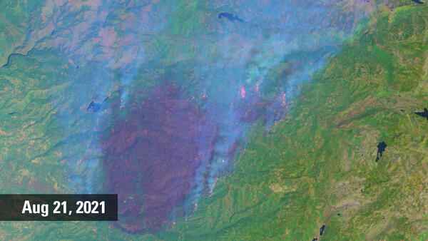
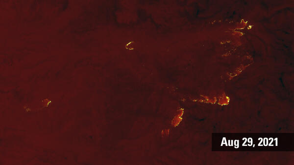
When the Caldor Fire ignited in August 2021, it moved quickly through the Sierra Nevada and toward the Lake Tahoe Basin, threatening communities, forests, and water supplies. Landsat monitored the fire as it spread and has continued tracking the burned area since, helping scientists follow forest regrowth and changes in the watershed.
Measuring Water Use
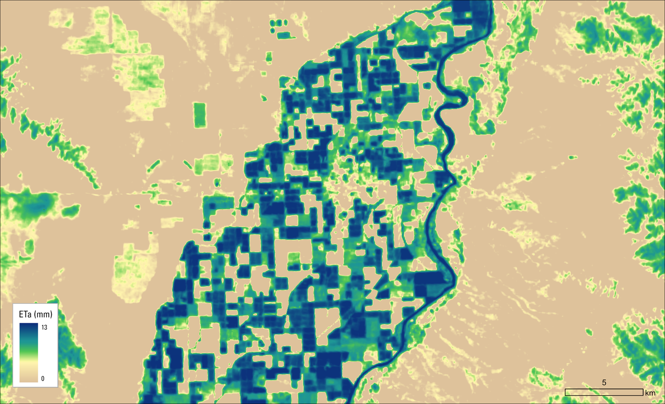
Landsat estimates evapotranspiration — the combined water loss from soils, crops, and natural vegetation — giving water managers a way to see how much water is being used across a landscape, and where.
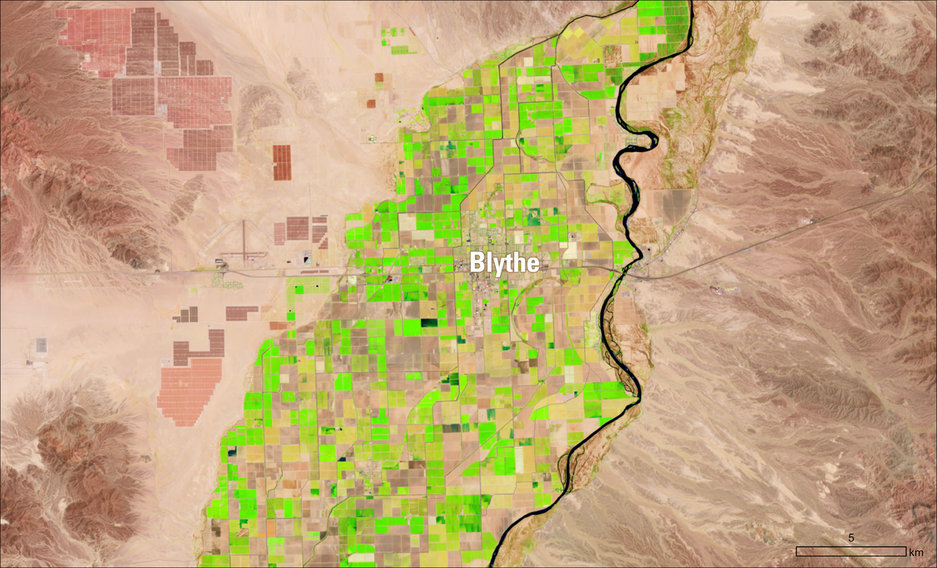
In agricultural areas like Blythe, California, this data supports field-scale estimates of water use, helping irrigation districts, farmers, and state agencies balance crop production with conservation and meet water accounting requirements. Because the Landsat record extends back decades, it can also show how water use shifts as growing seasons change, new crops are introduced, or water availability drives new management strategies.
Tracking Water Quality
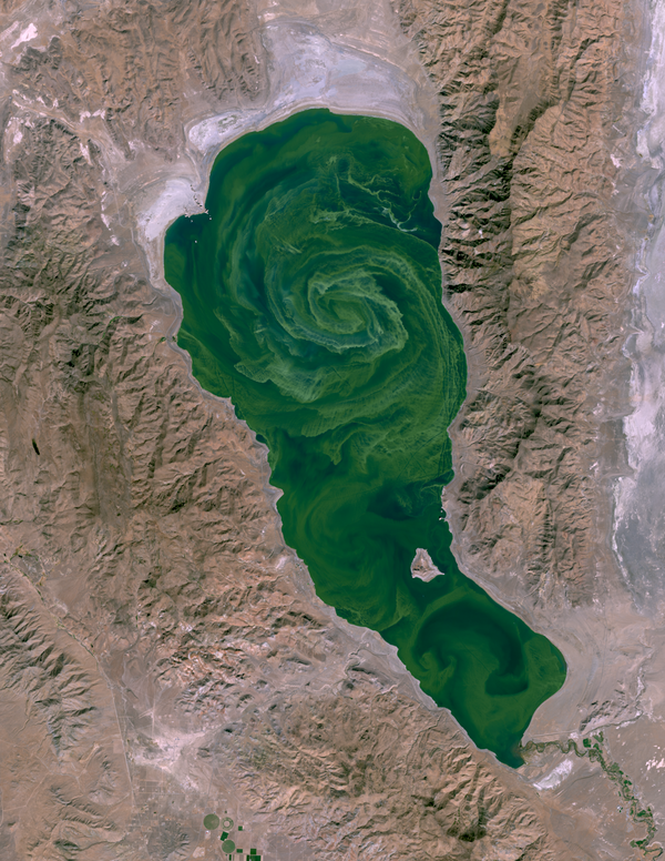
Landsat's thermal and multispectral data track water levels, surface conditions, and ecological health in reservoirs, river corridors, saline lakes, and coastal wetlands across the region — including early signs of harmful algal blooms and long-term changes driven by drought and water diversion.
Pyramid Lake, for instance, experiences algal blooms most years. In October 2024, Landsat 9's OLI-2 sensor captured dense bands of blue-green algae spreading across the lake's surface during an active bloom. Tribal water-quality monitors had already reported increasing bloom activity and more turbid water; Landsat's imagery showed how fast the bloom expanded and discolored the lake, with satellite data indicating it peaked in mid-October. This kind of imagery supports Tribal lake-health monitoring and helps document how drought and water use are reshaping the region's lakes over time.
Documenting Urban Growth
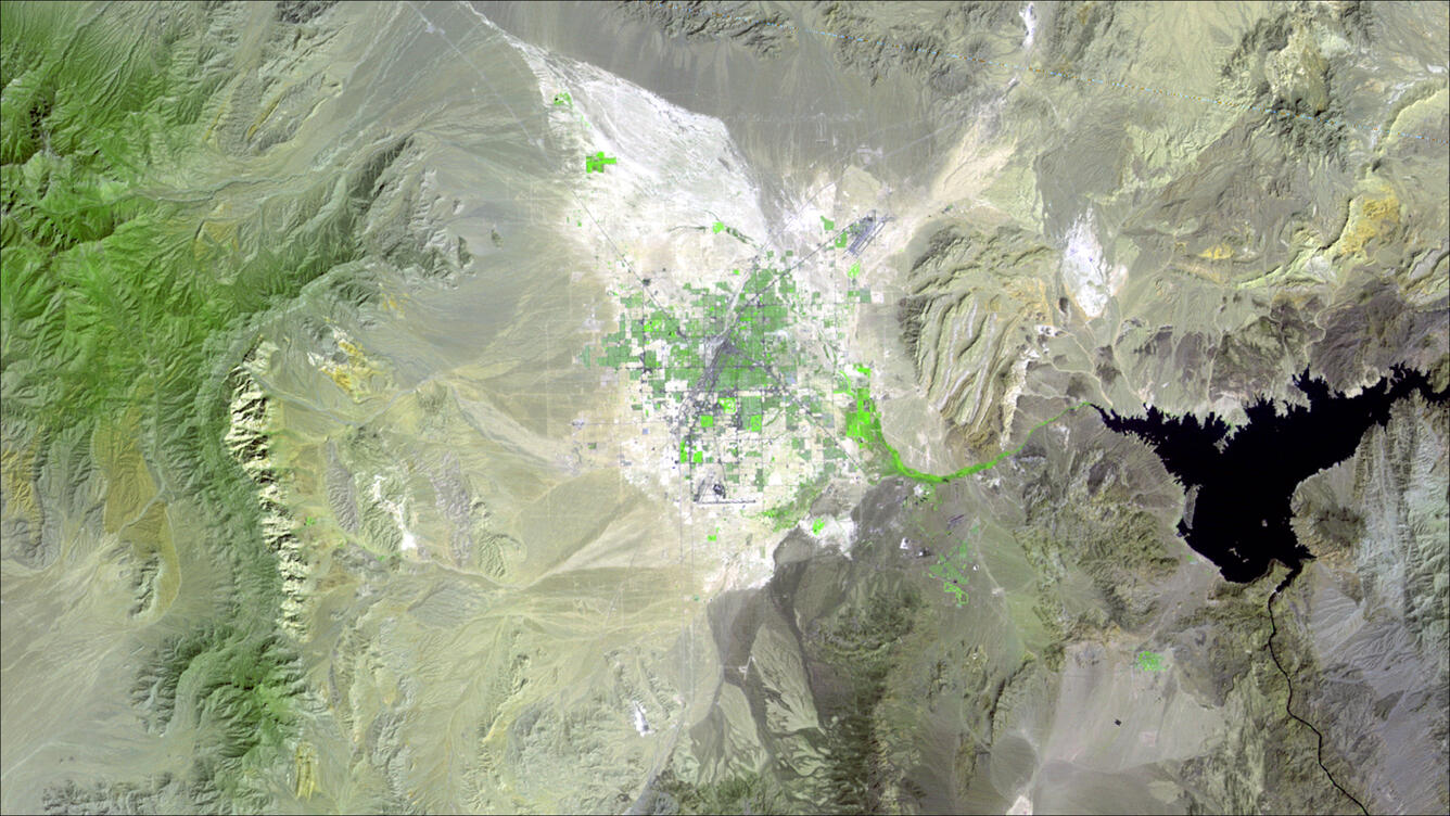
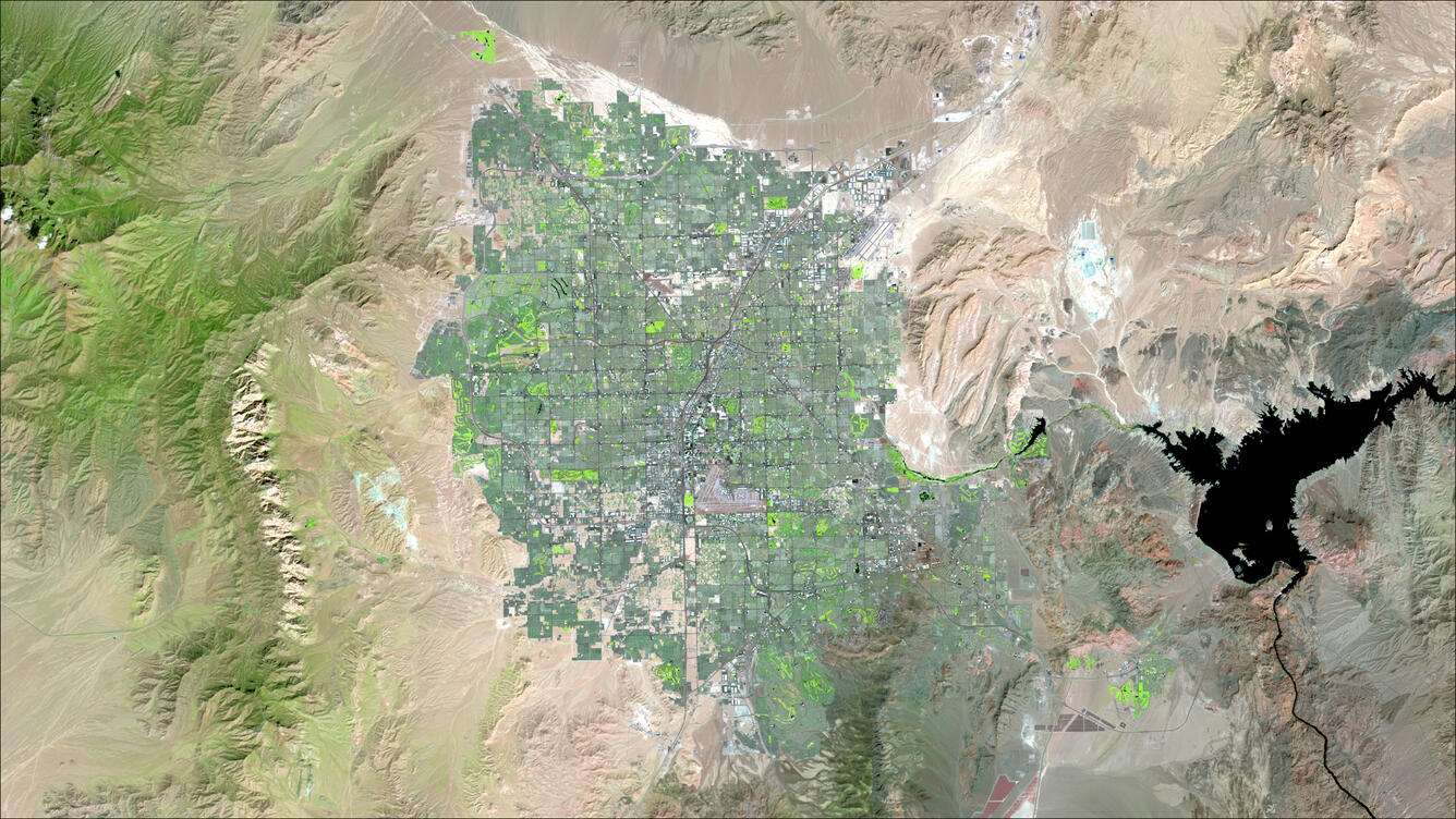
The Southwest is home to some of the nation's fastest-growing cities, and Landsat's continuous record since 1972 lets scientists, planners, and resource managers track urban expansion as it happens.
Las Vegas is one of the clearest examples. Over five decades, Landsat has documented the city's growth from a small urban center into a major metropolitan area, capturing changes in vegetation and impervious surfaces along the way. Comparing these images over time helps communities understand how expanding cities affect water demand and the surrounding desert environment.
Supporting Critical Mineral Development

The Southwest's geology has produced significant deposits of critical minerals, often in remote rangeland areas. Landsat imagery helps land managers, regulators, and developers understand these landscapes before and during mineral development.
At McDermitt Caldera and Thacker Pass, for example, Landsat data have helped identify sage-grouse habitat, assess rangeland conditions, and understand groundwater-linked vegetation. These insights help guide site selection, support environmental assessments and reviews required by state and federal agencies.
Calibrating Landsat
The Southwest plays an important role in keeping Landsat data accurate and consistent. Its clear skies, dry climate, and broad, uniform landscapes provide reliable reference targets for evaluating satellite sensors.
Sites such as Railroad Valley and Ivanpah Playa support radiometric calibration, while instrumented waters at Lake Tahoe and the Salton Sea help validate thermal measurements. The Phoenix metropolitan area is used to assess geometric accuracy, ensuring that Landsat pixels are correctly located on Earth. Together, these sites help maintain Landsat’s standing as a gold standard for Earth observation data.
Railroad Valley Playa
Ivanpah Playa
Lake Tahoe
Phoenix
Landsat Benefits, State by State
At 438 miles (705 km) above the Earth, Landsat satellites capture our planet. From mapping wildfires and permafrost thaw in Alaska to tracking algal blooms and spongy moth invasions in Rhode Island, the U.S. Geological Survey (USGS) Landsat Program offers an expansive list of benefits across all 50 States.
Learn how Landsat benefits your state.
Download your state's mosaic.