An official website of the United States government
Here's how you know
Official websites use .gov
A .gov website belongs to an official government organization in the United States.
Secure .gov websites use HTTPS
A lock () or https:// means you’ve safely connected to the .gov website. Share sensitive information only on official, secure websites.
On this day in 2008, the USGS announced their plan to ‘open’ the USGS EROS Landsat archives, making all Landsat data available to download at no charge, to all users worldwide. Fifteen years later, in the “Year of Open Science”, Landsat continues to lead how Earth Observation data is utilized, and how Landsat data is used to support science and research efforts.
As first described in this USGS Technical Announcement, the effort to open the USGS Landsat archive began with Landsat 7 ETM+ in late 2008 and followed with Landsat TM and Landsat MSS archives in early 2009.
Prior to 2008, the costs of obtaining Landsat scenes were prohibitive to science research and applications. Sales of Landsat 7 ETM+ data peaked in FY 2001 with 19,000 scenes sold; in FY 2008, over 86,000 scenes were downloaded at no cost. In August 2009, downloads reached the one-million mark. (Reference: Landsat’s Enduring Legacy, page 345).
As shown in the graph below, Landsat Level-1 scenes have been downloaded more than 160 million times since the Landsat archive became freely available. While Landsat Collection 1 data were downloaded directly from the USGS EROS Landsat archives, Collection 2 data and products can be accessed using a commercial cloud platform that offers new ways to explore the growing record of Landsat observations.
Example of the Landsat Collection 2 Provisional Evapotranspiration science product for agricultural fields on the Fucino plain near San Benedetto dei Marsi, Italy.
Opening the Landsat archive allowed scientists to utilize the Level-1 data to create higher-level science products and further science studies to better monitor, assess, and project how changes in land use, land cover, and land condition affect people and nature.
These Landsat Science Products are available to download at no charge from the USGS Landsat Archive:
Level-3 Burned Area, Dynamic Surface Water Extent, Fractional Snow Covered Area, Provisional Actual Evapotranspiration
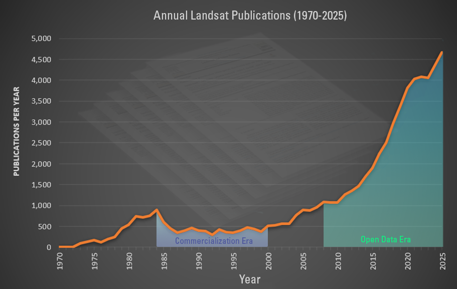
Citations Increase with Open Archive
While published works have always provided insights into the research done using Landsat data, the ability to obtain Landsat data at no charge has greatly helped researchers and scientists increase their publications and advance remote sensing science research.
For more than 20 years, members of the USGS/NASA Landsat Science Teams have been instrumental in creating many published works to support the Landsat mission. Consisting of USGS and NASA scientists and engineers, along with external scientists, engineers, and application specialists representing industry and university research initiatives, the Team provides scientific and technical evaluations to ensure the continued success of the Landsat program.
The graph below displays number of Landsat-related citations (orange line) and the cost per scene (blue line) from 1970 to 2022. As expected, citations increased greatly after the data became freely available starting in December 2008.
The White House has announced 2023 as the Year of Open Science, featuring actions across the federal government to advance national open science policy, provide access to the results of taxpayer-supported research, and advance adoption of open, equitable, and secure science.
To learn more about the history of the Landsat Program, the “Landsat’s Enduring Legacy” book is available for download from https://my.asprs.org/ASPRSMember/ASPRSMember/Publications/Landsat-Digital-Access.aspx. This book was compiled and reviewed by many Landsat experts, and describes in detail how “Landsat missions laid the foundation for modern space-based Earth Observation and blazed the trail in the new field of quantitative remote sensing.”
The Landsat webpages provide information and specifics about the satellite missions, the available data products, and how to obtain and use the Landsat-based data and science products available from the USGS.
Barbara Ryan, Director of GEO talks about the distribution of Landsat data, starting in 1972, and ultimately transitioning to the free and open policy of today.
Eyes on Earth Episode 19 – 100 Million Landsat Downloads
For decades, each Landsat image had a price tag – a hefty one at times, ranging from \$400 to as much as \$4,000. That all changed in 2008 with the enactment of an open data policy that made the entire Landsat archive available for download at no cost to the user.
For decades, each Landsat image had a price tag – a hefty one at times, ranging from \$400 to as much as \$4,000. That all changed in 2008 with the enactment of an open data policy that made the entire Landsat archive available for download at no cost to the user.
This Landsat 8 image from May 24th, 2017 shows an enthralling New Zealand landscape. Snow-capped mountain peaks, forests, farmland, and fog highlight the picturesque view of New Zealand's North Island. The scene was downloaded on March 9th, 2020 one of over 29,000 Landsat scenes downloaded worldwide that day. But this scene is special.
This Landsat 8 image from May 24th, 2017 shows an enthralling New Zealand landscape. Snow-capped mountain peaks, forests, farmland, and fog highlight the picturesque view of New Zealand's North Island. The scene was downloaded on March 9th, 2020 one of over 29,000 Landsat scenes downloaded worldwide that day. But this scene is special.
Since 1972, the Landsat program has been continually monitoring the Earth, to now provide 50 years of digital, multispectral, medium spatial resolution observations. Over this time, Landsat data were crucial for many scientific and technical advances. Prior to the Landsat program, detailed, synoptic depictions of the Earth's surface were rare, and the ability to acquire and work with...
Authors
Michael A. Wulder, David P. Roy, Volker C. Radeloff, Thomas Loveland, Martha C. Anderson, David M. Johnson, Sean Healey, Zhe Zhu, Theodore A. Scambos, Nima Pahlevan, Matthew Hansen, Noel Gorelick, Christopher J. Crawford, Jeffery G. Masek, Txomin Hermosilla, JoAnn C. White, Alan S. Belward, Crystal Schaaf, Curtis E. Woodcock, Justin L. Huntington, Leo Lymburner, Patrick Hostert, Feng Gao, Alexi Lyapustin, Jean-Francois Pekel, Peter Strobl, Eric Vermote, Bruce D. Cook
Data that have been processed to allow analysis with a minimum of additional user effort are often referred to as Analysis Ready Data (ARD). The ability to perform large scale Landsat analysis relies on the ability to access observations that are geometrically and radiometrically consistent, and have had non-target features (clouds) and poor quality observations flagged so that they can...
Authors
John L. Dwyer, David P. Roy, Brian Sauer, Calli B. Jenkerson, Hankui K. Zhang, Leo Lymburner
Groundwater dependent ecosystems (GDEs) rely on near-surface groundwater. These systems are receiving more attention with rising air temperature, prolonged drought, and where groundwater pumping captures natural groundwater discharge for anthropogenic use. Phreatophyte shrublands, meadows, and riparian areas are GDEs that provide critical habitat for many sensitive species, especially in...
Authors
Justin Huntington, Kenneth C. McGwire, Charles Morton, Keirith A. Snyder, Sarah Peterson, Tyler Erickson, Richard G. Niswonger, Rosemary W.H. Carroll, Guy Smith, Richard Allen
New and previously unimaginable Landsat applications have been fostered by a policy change in 2008 that made analysis-ready Landsat data free and open access. Since 1972, Landsat has been collecting images of the Earth, with the early years of the program constrained by onboard satellite and ground systems, as well as limitations across the range of required computing, networking, and...
Authors
Michael A. Wulder, Joanne C. White, Thomas Loveland, Curtis Woodcock, Alan Belward, Warren B. Cohen, Eugene A. Fosnight, Jerad Shaw, Jeffery G. Masek, David P. Roy
The geospatial community is experiencing a shift from having data locally to sharing them over the Web. However, not all the data accessing systems are built in compliance with open geospatial standards and thus are weak in terms of interoperability. The USGS Landsat data are now available through free electronic access though not yet through standard Web service interfaces. This paper...
The USGS Landsat archive holds an unequaled 36-year record of the Earth's surface that is invaluable to climate change studies, forest and resource management activities, and emergency response operations. An aggressive effort is taking place to provide all Landsat imagery [scenes currently held in the USGS Earth Resources Observation and Science (EROS) Center archive, as well as newly...
C. E. Woodcock, R. Allen, M. Anderson, A. Belward, R. Bindschadler, W. Cohen, F. Gao, S.N. Goward, D. Helder, E. Helmer, R. Nemani, L. Oreopoulos, J. Schott, Prasad S. Thenkabail, E. F. Vermote, James E. Vogelmann, M.A. Wulder, R. Wynne
In cooperation with the International Landsat community, and through the Landsat Technical Working Group (LTWG), NOAA is assembling information about the status of the Worldwide Landsat Archive. During LTWG 9, member nations agreed to participate in a survey of International Landsat data holding and of their archive experiences with Landsat data. The goal of the effort was two-fold; one...
Free, Open Landsat Data Unleashed the Power of Remote Sensing a Decade Ago
In the old days, before 2008, a view of planet Earth from space often came at a cost. Want a Multispectral Scanner digital image in 1979 from Landsat...