
New Landsat Collection 2 Science Products Released
Landsat Collection 2 Level-2 Provisional Aquatic Reflectance (AR) and Level-3 Provisional Actual Evapotranspiration (ETa) science products are now available. Landsat 9 is also now available for both products.
Landsat 8-9 Provisional Aquatic Reflectance
Derived from Landsat Collection 2 Level-1 visible to near-infrared (VNIR) spectral bands, Aquatic Reflectance (AR) measures the spectral distribution of solar-reflected radiation upwelling from the upper water column in aquatic ecosystems. Landsat Collection 2 Provisional AR allows users the capability to map optical constituents of inland and coastal water bodies across the globe.

The global provisional Landsat 8-9 AR product allows users to retrieve aquatic properties for inland waters and coastal ocean environments without manual preprocessing. This product expands access to reliable aquatic reflectance over optically complex marine and freshwater ecosystems for remote sensing and application communities.
“High-quality AR products empower scientists to track changes in the composition of water constituents in response to climate variability, extreme weather events, and anthropogenic stressors,” shared Principal Investigator Nima Pahlevan. “Water resource managers will also be able to identify areas of concerns that may correspond to impaired water conditions induced by algal blooms or illegal/accidental discharges.” Dr. Chris Crawford, USGS Landsat Project Scientist, shared that “these Collection 2 Landsat 8/9 Provisional AR products advance Landsat’s science mission capabilities and will usher in a new era of medium resolution aquatic remote sensing science, mapping, and monitoring.”
A number of improvements and changes have been made in Collection 2 Provisional AR, including the addition of Landsat 9. Details about these improvements, along with technical details about Collection 2 Provisional AR can be found on the Landsat Collection 2 Provisional Aquatic Reflectance Science Product webpage.
Landsat 4-9 Provisional Actual Evapotranspiration
Actual Evapotranspiration (ETa) is the quantity of water that is removed from a surface due to the processes of evaporation and plant transpiration and is measured in millimeters (mm). Landsat Collection 2 Provisional ETa is scene-based and derived using the Landsat Collection 2 Level-2 Surface Temperature products, and is available globally. Landsat Surface Temperature is input to a surface energy balance model with external auxiliary data to retrieve the daily total of ETa.
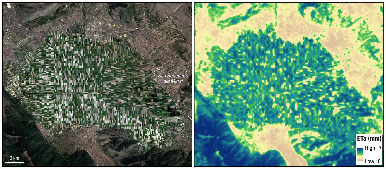
The ETa science product allows for consistent, accurate ETa estimates by leveraging the capabilities of the Landsat archive. Landsat’s quality radiometric and geometric calibration and its coincident thermal infrared imaging with multispectral visible-to-shortwave infrared (VSWIR) enables reflectance enables energy balance evapotranspiration techniques to be deployed to accurately determine how much water is being used where and when around the world.
ETa estimates provide useful information for a range of applications that include calculating a basin’s water budget to assess of water consumption, crop yields and drought impacts. It is also crucial for understanding Earth’s energy and water budgets coupled with the carbon cycle.
“The remote sensing, agricultural, and water management community will have globally consistent ETa data that can be used for multi-scale decision making from localized irrigation scheduling to basin water budget studies,” shared USGS Principal Investigator Gabriel Senay.
Several improvements and changes have been made in Collection 2 ETa, including global availability and the addition of Landsat 9. Details about these improvements, along with technical details about Collection 2 ETa can be found on the Landsat Collection 2 Provisional Actual Evapotranspiration Science Product webpage.
Data Access
Requests for Landsat Collection 2 Provisional AR and ETa products can be submitted using the EROS Science Processing Architecture On-Demand Interface (ESPA).
Please contact USGS EROS Customer Services with any questions about these products.