Latest in Landsat August 2025 - Vol. 4 | Issue 7
The WHERE and WHEN of Landsat Satellite Acquisitions
New USGS Data Release shares details of Landsat acquisition priorities
You may know that the Landsat 8 and Landsat 9 satellites together downlink enough data to the USGS EROS archive that equates to about 1,500 scenes per day. But do you know how we decide where the satellites collect data each day?
These factors are the primary factors used to determine daily Landsat acquisitions:
- Seasonality, when during the year imagery was collected
- Land definition, knowing what is land vs open ocean
- Historical cloud cover, based on past Landsat observations
- Gain settings, knowing how the actual brightness values changes sensor sensitivity
- Sun angle, the position of the sun when imagery is collected
Each factor itself could cause uncertainties when trying to collect Earth imagery; but when each parameter is applied with precision, acquiring Landsat data becomes a very steadfast approach. Below, dive into a new USGS Data Release to learn more about the rationale for success data acquisitions.
-
The Landsat 8/9 Long Term Acquisition Plan for Earth’s continental landmasses and near-shore coastal zones, Version 1.0 The Landsat 8/9 Long Term Acquisition Plan for Earth’s continental landmasses and near-shore coastal zones, Version 1.0
Landsat 8 and Landsat 9 Earth imaging acquisitions are guided by their respective Long Term Acquisition Plan (LTAP), that has been established for each satellite observatory. The LTAP is structured around the Worldwide Reference System-2 (WRS-2) grid, which partitions Landsat swath imaging of the Earth into ~185 × 180 km scenes using a path/row notation. These WRS-2 scenes represent the
Land Cover Reference and Validation Data Now Available
The Annual National Land Cover Database (NLCD) uses an ensemble of classification and change algorithms to map, monitor, and synthesize the complexities of land use, cover, and condition change through time. The Annual NLCD product suite offers data that describe nationwide land cover and land change over nearly four decades.
To help users understand the reliability of NLCD — as well as any limitations it may pose in their particular areas of study — a recently released dataset containing over 8,000 plots provides statistical accuracy assessments of the land use and land cover change data, as well as the source reference data.
Access the entire article below to learn more about the validation that was completed in June 2025.
-
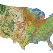
New Reference and Validation Data Available for Annual NLCD New Reference and Validation Data Available for Annual NLCD
The U.S. Geological Survey (USGS) has released the reference and validation data for Annual National Land Cover Database (NLCD) Conterminous U.S. (CU), Collection 1.0, from 1985 to 2023.
July's Highlighted Articles and Celebrations

Celebrating 53 Years Since the Launch of Landsat 1
This article was written by the NASA and USGS Landsat Science Communication teams to mark the 53rd anniversary of Landsat 1.

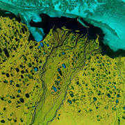
One Million Reasons to Celebrate Landsat 9
The USGS Earth Resources Observation and Science (EROS) Center archive now contains more than one million Landsat 9 Level-1 products (that’s over 1 billion megabytes of Earth observation data)!
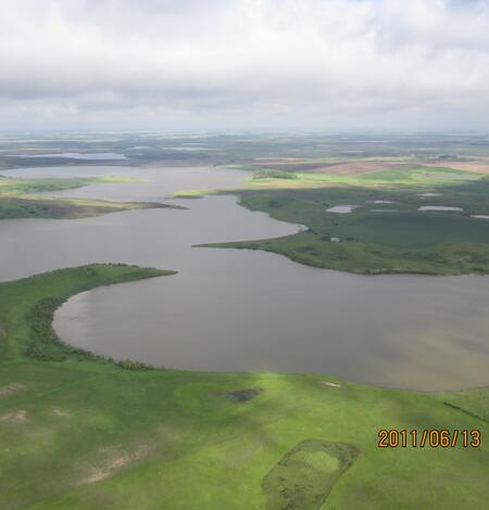
Plenty of Water in Prairie Potholes
The landscape of the Prairie Pothole Region of North and South Dakota formed when glaciers from the last ice age receded. The potholes are shallow depressional wetlands left behind by the glaciers now popular with migratory waterfowl.
Recently Published USGS Products
-
Landsat Collection 2 temporal cloud truth mask validation set Landsat Collection 2 temporal cloud truth mask validation set
The U.S. Geological Survey (USGS) Earth Resources Observation and Science (EROS) Center in Sioux Falls, SD has developed a cloud validation dataset from Collection 2 images throughout the history of Landsat. Two North American locations with high overlap between WRS-1 and WRS-2 were chosen. For each location, 20 images were selected at random from the Landsat archive, with at least one...
-
ECCOE Landsat quarterly Calibration and Validation report—Quarter 4, 2024 ECCOE Landsat quarterly Calibration and Validation report—Quarter 4, 2024
Executive Summary The U.S. Geological Survey Earth Resources Observation and Science Calibration and Validation (Cal/Val) Center of Excellence focuses on improving the accuracy, precision, calibration, and product quality of remote-sensing data, leveraging years of multiscale optical system geometric and radiometric calibration and characterization experience. The Earth Resources...
-
Brief communication: Not as dirty as they look, flawed airborne and satellite snow spectra Brief communication: Not as dirty as they look, flawed airborne and satellite snow spectra
Key to the success of spaceborne missions is understanding snowmelt in our warming climate, as this has implications for nearly 2 billion people. An obstacle is that surface reflectance products over snow show an erroneous hook with decreases in the visible wavelengths, causing per-band and broadband reflectance errors of up to 33 % and 11 %, respectively. This hook is sometimes mistaken...
Want to learn more about Landsat? Check these out!
-

Landsat Frequently Asked Questions Landsat Frequently Asked Questions
This page lists commonly asked questions pertaining to the Landsat satellite missions, the science behind maintaining high quality Landsat data, and what products are available - and how to download them.
-
Landsat Glossary and Acronyms Landsat Glossary and Acronyms
The Landsat project uses many technical terms and acronyms to describe the satellite systems, sensors, and data formats. This information is vital for interpreting satellite imagery and using Landsat data in research and environmental monitoring. Access this information to locate the terms to learn more!
-

Connect Connect
Access the information on this page to learn more about Landsat, access our social media platforms, or contact us with questions you have about the Landsat missions, the available science products, and how to access Landsat data!
Keep up to date with Latest in Landsat!
Direct to your inbox, Landsat's monthly newsletter features current news, uses, tools, and announcements about America's Earth-observing satellite program.
The Landsat Program is a joint effort of the U.S. Geological Survey (USGS) and the National Aeronautics and Space Administration (NASA). This partnership creates the unprecedented, continuous record of changes to the Earth's surface worldwide.