
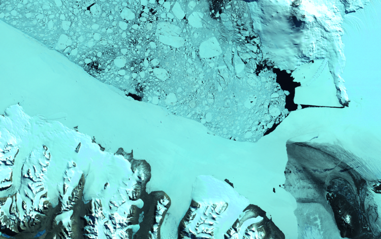
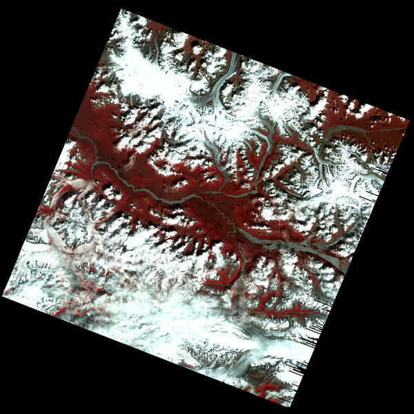
This early Landsat 1 image, acquired on July 31, 1972, captures the Kennicott, Nabesna, and Barnard Glaciers in southeastern Alaska—just a week after the satellite’s launch. Using bands 6, 5, and 4, the image reveals glacial ice, rugged mountain terrain, and braided rivers within the Wrangell–St. Elias region.
Celebrating 53 Years Since the Launch of Landsat 1
By Landsat Missions
July 23, 2025
This article was written by the NASA and USGS Landsat Science Communication teams to mark the 53rd anniversary of Landsat 1.
A New Era in Earth Observation
A New Era in Earth Observation
Media

Sources/Usage: Public Domain. View Media Details
With a swarm of satellites now circling the Earth, it’s easy to take for granted the unique value of monitoring our home planet from space. In the 1970s, however, the idea was still novel. When the Earth Resources Technology Satellite (ERTS-1)—what we now call Landsat 1—launched in 1972, it posed the following question: could we manage our natural resources using remotely-sensed data? The answer, 53 years on, is a resounding “yes.”
Even before the launch of ERTS-1, there were 305 proposed investigations across various disciplines, according to the ERTS-A Press Kit.
Members of the Landsat project office understood the value of the program would depend on the practical and widespread uses of the data collected by the ERTS Multispectral Scanner (MSS) instrument. In June 1970, NASA requested proposals for the use of data from researchers around the world. (Etter Mack). The accepted proposals came from a diverse range of institutions including universities, industry, non-profit organizations, and federal and state government agencies, demonstrating the broad interest in utilizing this new Earth observation capability. These were categorized into different scientific disciplines, covering everything from agriculture and forestry to geology and hydrology.
Early Achievements and Use Cases
By 1975, there were 334 scientific experiments conducted and reported to NASA as part of the ERTS program (Bidwell and Mitchell). A summary of the accomplishments from these studies were described in the ERTS-B (Landsat 2) Press Kit covering six application areas.
Agriculture & Forestry
- Estimated wheat acreage in Kansas with 99% accuracy
- Identified agricultural classes in California's Central Valley faster and with more detail than with conventional methods
- Classified 7 crop types with over 90% accuracy using multitemporal data in Nebraska
- Estimated timber volume in National Forests at 1/10th the cost of traditional surveys
- Estimated timber volume taken through clear-cutting and burned in wildfires
- Identified areas of controlled grazing in the otherwise barren Sahel desert
Land Use & Mapping
- Created up-to-date maps in days, a huge improvement on the months or years with conventional mapmaking methods
- Produced first large-scale land use inventory for Alaska, aiding the selection of 220 million acres of public domain land
- Aided revision of official maps, including adding water bodies on the Virginia state base map
- Uncovered previously unknown Antarctic features including a group of mountains
- Demonstrated that 1:250,000 scale photomap product based on ERTS imagery can meet National Map Accuracy Standards
- Enabled states including Michigan, Minnesota, New York, and Wisconsin to update land use systems
Water Quality and Resources
- Provided first global estimates of inland surface water coverage[
- Enabled rapid flood area assessment during 1973 Mississippi River floods below Memphis, Tennessee
- Tracked glacier edge (terminus) movement and surging glacier advance
- Improved snowmelt runoff prediction for western U.S. water management
- Developed numerical water distribution models for south Florida to strengthen strategic management plans
Minerals & Geology
- Revealed previously unknown structural features, such as faults and fractures, that could present hazards to human communities
- Discovered potential oil-bearing zone in northern Alaska
- Found anomalous features correlated with producing oil and gas fields in Oklahoma
- Successfully guided water well drilling in Arizona sandstone deposits
Marine Resources
- Mapped coastal water circulation patterns using sediment as natural tracer
- Identified ice type, distribution, and movement, facilitating planning of shipping routes
- Developed bathymetry measurement technique for depths up to 9 meters (30 feet)
- Updated locations of reefs and shoals on hydrographic charts
- Located menhaden fish schools using image-density patterns
Environmental Monitoring
- Investigated water quality by tracking turbidity and large-scale water pollution events
- Detected suspended solids in concentrations from 5 to 1000 mg/liter and chlorophyll in water
- Investigated vegetation quality in diverse ecosystems ranging from deserts to mountains
- Classified strip-mined areas for acreage assessment and reclamation monitoring
- Monitored wetlands changes from construction and dredging activities
- Improved maps of wildlife habitats for better management
Sources/Usage: Public Domain. View Media Details

Federal Adoption and Use
Federal Adoption and Use
The United States Geological Survey (USGS), which planned the ERTS program alongside NASA, was the largest operational user of ERTS-1 data. In the first years of ERTS-1 in orbit, the USGS used the data to monitor strip mining, locate oil and mineral deposits, map flooding, and identify land use change. The USGS also played a large role in encouraging the widespread use of remote sensing by developing new techniques, providing training, and encouraging operational use programs throughout the federal government and beyond.
Between the launches of ERTS-1 and ERTS-2 (later renamed Landsat 2), the USGS and three other federal agencies—the Department of Agriculture, the Army Corp of Engineers, and the National Oceanic and Atmospheric Administration (NOAA)—began investigating how they could use ERTS data. The Department of Agriculture identified major applications areas, including inventorying and monitoring agricultural, range, and forested lands; tracking changes in the urban-rural interface; and monitoring wildlife habitat for management. The Army Corps of Engineers used ERTS-1 data for the National Dam Safety Program, to develop large-area environmental impact statements, and to study the Atlantic and Pacific coasts of the U.S. In anticipation of the launch of ERTS-2, the Corps of Engineers planned multiple NASA-funded investigations focused on reservoir management, coastal planning, and environmental impact prediction. NOAA used ERTS-1 data to improve aeronautical charts and identified further operational uses of ERTS data including water quality monitoring, impact assessments of human activity on fisheries, and snow cover analysis.
Lasting Impact and Legacy
Lasting Impact and Legacy
Landsat 1 fundamentally changed Earth observation. Its groundbreaking MSS was the first Earth-observing instrument designed to obtain calibration data in orbit and established standards for satellite-based Earth observation. What began as an experimental satellite, has grown into one of the longest-running and most valuable Earth observation programs in the world. Today, the Landsat archive supports billions in annual economic benefits across sectors like agriculture, forestry, water resources, geology and mineral exploration, and environmental monitoring. Research in each of these key application areas has grown as each new Landsat mission innovated on previous technology. That legacy continues and will expand with the next generation of Landsat satellites.
References
Allaway, H.; Witten, D.; McDavid, J.; Finley, D.; Bottorff, M.; Handy, J.; Thomas, C. ERTS-B Press Kit; NASA: Washington, D.C., 20546, 1975. https://www.google.com/books/edition/Project_ERTS_B/9JjX7fSnhyUC?hl=en&gbpv=1
McRoberts, J.; Lynch, J. ERTS Press Kit; NASA: Washington, D.C., 20546, 1972. https://ntrs.nasa.gov/api/citations/19760066719/downloads/19760066719.p…
Pamela Etter Mack. Viewing the Earth : The Social Construction of the Landsat Satellite System; Mit Press: Cambridge, Mass., 1990.
Timothy C. Bidwell and Cheryl A. Mitchell. Author index to published ERTS-1 Reports. Sioux Falls, SD: Technicolor Graphics under contract to USGS EROS Data Center, 86. 1975. https://pubs.usgs.gov/unnumbered/70159283/report.pdf
Related
")
EROS Data Center Earth Resources Technology Satellite (ERTS)
A 1973 video from the EROS History Project on the value of the Earth Resources Technology Satellite (ERTS), which was later renamed Landsat.
First Glimpse of Alaska’s Glaciers from Landsat
This early Landsat 1 image, acquired on July 31, 1972, captures the Kennicott, Nabesna, and Barnard Glaciers in southeastern Alaska—just a week after the satellite’s launch. Using bands 6, 5, and 4, the image reveals glacial ice, rugged mountain terrain, and braided rivers within the Wrangell–St. Elias region.

Landsat 1 views Alaska Fire
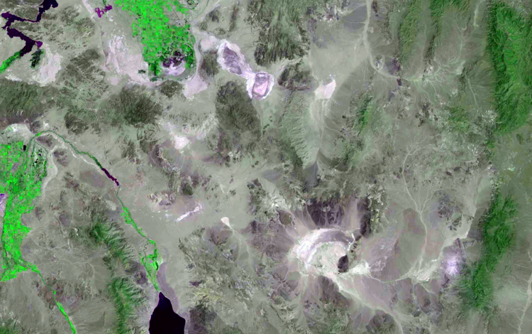
Within days of the launch, Landsat 1 acquired an image of an astounding 81,000-acre (327.8 square kilometers) fire burning in isolated, central Alaska. For the first time ever, scientists and resource management officials were able to see the full extent of damage from a fire in a single image while it was still burning.
Within days of the launch, Landsat 1 acquired an image of an astounding 81,000-acre (327.8 square kilometers) fire burning in isolated, central Alaska. For the first time ever, scientists and resource management officials were able to see the full extent of damage from a fire in a single image while it was still burning.

Landsat 1 First Light Image of Texas
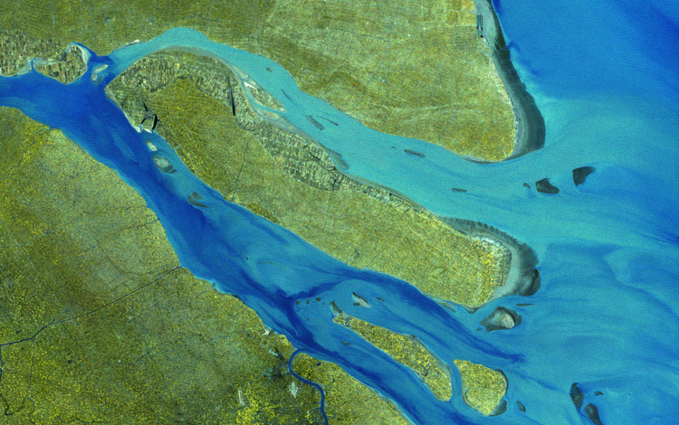
Dallas-Fort Worth, Texas, slid into Landsat 1's view on July 25, 1972. In this false-color image, shades of red indicate vegetated land and grays and whites are urban or rocky surfaces. The composite image is shown using the near-infrared, red and green bands (bands 7, 5, 4) at a 60 meter resolution.
Dallas-Fort Worth, Texas, slid into Landsat 1's view on July 25, 1972. In this false-color image, shades of red indicate vegetated land and grays and whites are urban or rocky surfaces. The composite image is shown using the near-infrared, red and green bands (bands 7, 5, 4) at a 60 meter resolution.
Related
EROS Data Center Earth Resources Technology Satellite (ERTS)
A 1973 video from the EROS History Project on the value of the Earth Resources Technology Satellite (ERTS), which was later renamed Landsat.
First Glimpse of Alaska’s Glaciers from Landsat
This early Landsat 1 image, acquired on July 31, 1972, captures the Kennicott, Nabesna, and Barnard Glaciers in southeastern Alaska—just a week after the satellite’s launch. Using bands 6, 5, and 4, the image reveals glacial ice, rugged mountain terrain, and braided rivers within the Wrangell–St. Elias region.
This early Landsat 1 image, acquired on July 31, 1972, captures the Kennicott, Nabesna, and Barnard Glaciers in southeastern Alaska—just a week after the satellite’s launch. Using bands 6, 5, and 4, the image reveals glacial ice, rugged mountain terrain, and braided rivers within the Wrangell–St. Elias region.
Landsat 1 views Alaska Fire
Within days of the launch, Landsat 1 acquired an image of an astounding 81,000-acre (327.8 square kilometers) fire burning in isolated, central Alaska. For the first time ever, scientists and resource management officials were able to see the full extent of damage from a fire in a single image while it was still burning.
Within days of the launch, Landsat 1 acquired an image of an astounding 81,000-acre (327.8 square kilometers) fire burning in isolated, central Alaska. For the first time ever, scientists and resource management officials were able to see the full extent of damage from a fire in a single image while it was still burning.
Landsat 1 First Light Image of Texas
Dallas-Fort Worth, Texas, slid into Landsat 1's view on July 25, 1972. In this false-color image, shades of red indicate vegetated land and grays and whites are urban or rocky surfaces. The composite image is shown using the near-infrared, red and green bands (bands 7, 5, 4) at a 60 meter resolution.
Dallas-Fort Worth, Texas, slid into Landsat 1's view on July 25, 1972. In this false-color image, shades of red indicate vegetated land and grays and whites are urban or rocky surfaces. The composite image is shown using the near-infrared, red and green bands (bands 7, 5, 4) at a 60 meter resolution.