In late March of 2021, just four miles from the edge of South Dakota's second-largest city, two wildfires sparked by human activity burned through a section of the Black Hills.
South Dakota and Landsat
See South Dakota from Space
Use the links below to explore more Landsat resources highlighting South Dakota.
Detailed Description
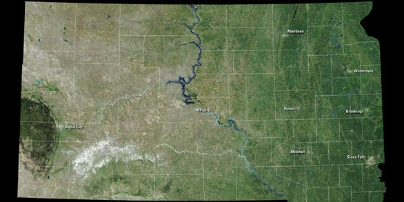
Few States derive as much of their social and economic well-being from the land as South Dakota. Agriculture is the State’s primary industry, likely because the fertile soil of eastern South Dakota consistently produces some of the largest corn and soybean yields in the United States. The State is also a top producer of spring wheat, flaxseed, hay, oats, rye, and sunflower seeds.
South Dakota is also famed for its hunting and fishing. Tens of thousands of visitors each year descend upon its rolling fields and grasslands to hunt the State bird, the Phasianus colchicus (Linnaeus, 1758) (ring-necked pheasant), or the waterfowl of northeastern South Dakota’s prairie pothole region. Visitors to western South Dakota marvel at the beauty of the Black Hills, Mount Rushmore, and Badlands National Park.
Mining and energy are also important to South Dakota. Much of the corn not used in food production or fed to livestock is used to make ethanol at one of several plants in the State, and hydroelectric power from the Missouri River provides the bulk of the energy used by its 800,000 residents. All but one of South Dakota’s gold mines have ceased operations, but mining continues for mica, construction sand and gravel, crushed stone, and more. Data from the USGS Landsat program, archived at the USGS EROS Center just outside Sioux Falls, South Dakota, has long been a boon to the monitoring, mapping, and management of the State’s land resources.
Visit Landsat Benefits, State By State to learn more about how Landsat brings science to your state.
Sources/Usage
Public Domain.
Related Content
Explore related podcasts, images and videos!
Image of the Week - Wildfires Burn in the Shadow of Mount Rushmore
In late March of 2021, just four miles from the edge of South Dakota's second-largest city, two wildfires sparked by human activity burned through a section of the Black Hills.
Scientists at EROS have spent years refining their approach to mapping burn severity using remotely-sensed data from satellites like Landsat, but Landsat comes with limitations. Landsat data cannot see the vegetation below a thick tree canopy, for example.
Abnormally high spring rainfall and subsequent flooding in the Midwest had a season-long impact on cropland production. In these Landsat images of South Dakota growing vegetation is shown as green and unplanted areas appear pink. The difference between 2018 and 2019 is striking.
A Landsat satellite image captured the flooding in Dell Rapids, SD in the Spring of 2019. It's remarkably similar to an aerial photograph of flooding 50 years earlier.
The high-water marks set by the Big Sioux River in cities across southeastern South Dakota have threatened to overtake records set 50 years ago, when the Army Corps of Engineers led missions to document the damage through hundreds of aerial photographs.
October 16, 2018, marks the two-year anniversary of the Cottonwood Fire in western South Dakota. The fire consumed a large swath of grassland near the community of Wall and just north of Badlands National Park.
Ponderosa pine forests in the Black Hills of South Dakota are the focus of this week’s USGS Image of the Week.
Many lakes in South Dakota’s Prairie Pothole Region are expanding.
Lake Thompson in eastern South Dakota is one that has displayed remarkable change in recent decades.
Many lakes in South Dakota’s Prairie Pothole Region are expanding.
Lake Thompson in eastern South Dakota is one that has displayed remarkable change in recent decades.
South Dakota and Landsat
With EROS Earthshots, travel the world at your own pace and see changes to the Earth's surface in these satellite images of environmental transformation. Start in South Dakota with a Black Hills infestation, enlarging Lake Thompson and a hailstorm at EROS.
Black Hills Infestation
Lake Thompson
EROS Hailstorm
Earthshots
The surface of the Earth is always changing. Some changes like earthquakes, volcanoes, floods, and landslides happen quickly, and other changes, such as most erosional processes, happen slowly over time. It’s often hard to see these changes from ground level. Earthshots shows you how satellite data are used to track these changes over time.