
Virginia Coastal Plain Aquifer systems

Detailed Description
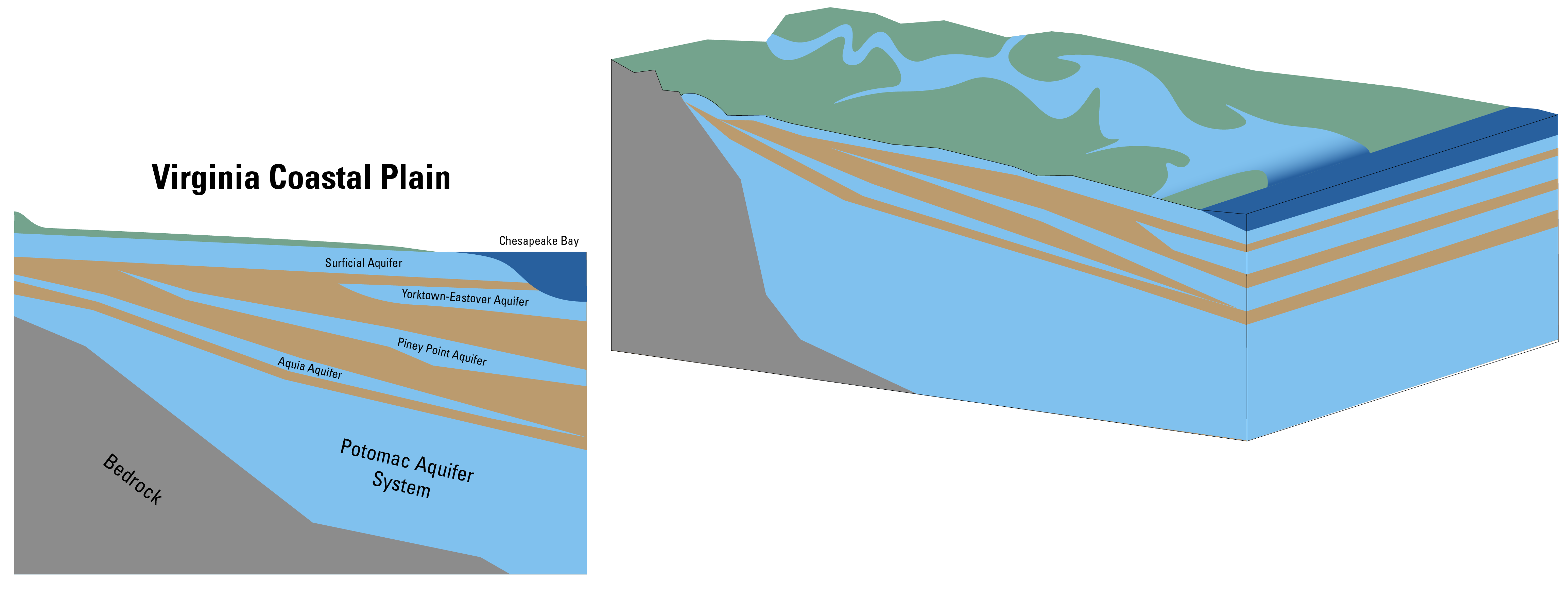
The Virginia Coastal Plain is the relatively flat region east of the fall line characterized by a wedge of coarse permeable sediments with interbedded layers of less-permeable silts and clays that thickens towards the east. The region has multiple layered aquifers, including the Potomac aquifer system.
In the Virginia Coastal Plain, about 75% of groundwater withdrawn from aquifers comes from the Potomac aquifer system, the deepest of Eastern Virginia's aquifers. The Potomac aquifer system is composed of loose sediments, with less permeable clay layers distributed throughout, and is relied upon for residential, commercial, and industrial water use.
Modified from McFarland and Bruce (2006) and Matterson et al. (2013b).
Sources/Usage
Public Domain.
Modified from:
- McFarland, R.E., & Scott, B.T., 2006, The Virginia Coastal Plain Hydrogeologic Framework: U.S. Geological Survey Professional Paper 1731, https://doi.org/10.3133/pp1731
- Masterson, J.P., Pope, J.P., Monti, Jack, Jr., Nardi, M.R., Finkelstein, J.S., and McCoy, K.J., 2015, Hydrogeology and hydrologic conditions of the Northern Atlantic Coastal Plain aquifer system from Long Island, New York, to North Carolina (ver. 1.1, September 2015): U.S. Geological Survey Scientific Investigations Report 2013–5133, 76 p., https://doi.org/10.3133/sir20135133.
Related

Land Subsidence on the Virginia Coastal Plain

Virginia Eastern Shore Groundwater Resources
Virginia Coastal Plain Infographics


Related
Land Subsidence on the Virginia Coastal Plain